
GIS (Geographic Information System) platform based spatial massive multivariate data unified index method

A multi-data and platform technology, applied in the direction of structured data retrieval, digital data processing, geographic information database, etc., can solve the problem of increasing the number of disk accesses, achieve fast and efficient query, and facilitate dynamic expansion and change.

Active Publication Date: 2015-01-07
SHANDONG LUNENG SOFTWARE TECH
View PDF3 Cites 9 Cited by
  • Summary
  • Abstract
  • Description
  • Claims
  • Application Information

AI Technical Summary

Problems solved by technology

For example, due to the large amount of multivariate data, the number of disk accesses of the traditional in-memory index structure is greatly increased

Method used


Image

  • GIS (Geographic Information System) platform based spatial massive multivariate data unified index method
  • GIS (Geographic Information System) platform based spatial massive multivariate data unified index method

Examples


Embodiment Construction

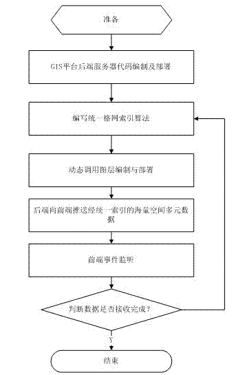
[0022] Accompanying drawing is a kind of specific embodiment of the present invention. A kind of unified indexing method of spatial massive multivariate data based on the GIS platform of this embodiment comprises the following steps:

[0023] (1), GIS platform back-end server code compilation and deployment, real-time reception of geographic coordinate data of related equipment resources;

[0024] (2) According to the geographical coordinate information of the received related equipment resources, write the grid space index method, divide the received data according to the fixed grid, the form of the grid is 8*8, to fall into each grid In the indexing of the objects in the grid, the objects that fall into each grid are correctly placed in the grid. During the retrieval process, the grid where the object is located is accurately judged, and the object is accurately selected to obtain its space. data and corresponding attribute data;

[0025] (3) Call its layer data according ...


PUM


Abstract

The invention belongs to the technical field of GIS (Geographic Information System) engineering and intelligent decision making and particularly relates to a GIS platform based spatial massive multivariate data unified index method. The GIS platform based spatial massive multivariate data unified index method comprises the following steps of compiling and deploying codes of a back-end server of a GIS platform; compiling a grid spatial index method according to received geographical coordinate information of associated equipment sources; calling layer data according to the received massive multivariate data; performing dynamic calling on layer compiling and deployment and dynamically calling on the layer data according to logical processing of the received massive multivariate data; monitoring GIS platform events; display data at the front end of an GIS platform. The GIS platform based spatial massive multivariate data unified index method can greatly quicken the data searching degree, obviously reducing inquire grouping and the sorting time and effectively improve the GIS platform analysis display efficiency and provides a brand new solution scheme for power grid equipment resource management and GIS platform analysis.

Description

(1) Technical field [0001] The invention belongs to the technical field of geographic information system engineering and intelligent decision-making, and in particular relates to a unified indexing method for massive spatial multivariate data based on a GIS platform. (2) Background technology [0002] With the wide application of mobile Internet and Internet of Things technology, the data volume of spatial multivariate information is increasing rapidly, and the massive data makes the traditional spatial multivariate data index face new challenges. For example, due to the massive multivariate data, the number of disk accesses of the traditional in-memory index structure is greatly increased. The main purpose of establishing a spatial index mechanism is to facilitate the positioning of spatial objects and various retrieval operations. It is very necessary to establish the index structure of point, line and space-oriented data (basic grid filling data of surface elements),...

Claims


Application Information

Patent Timeline
Patent Type & Authority Applications(China)
IPC IPC(8): G06F17/30
CPCG06F16/29
Inventor 田兵石鑫磊王茜张伟吴光洲周强贾楠
Owner SHANDONG LUNENG SOFTWARE TECH
Learn More