Bus GPS track data road network matching method

A trajectory data and road network matching technology, applied in the field of transportation, can solve problems such as the complexity of the search process

Inactive Publication Date: 2015-01-28
BEIJING UNIV OF CIVIL ENG & ARCHITECTURE
View PDF3 Cites 118 Cited by
  • Summary
  • Abstract
  • Description
  • Claims
  • Application Information

AI Technical Summary

Problems solved by technology

[0006] (2) The search process of the grid where the candidate matching road segment is located is relatively complicated
However, because the number of neighborhood grids varies with position, there are 3, 5, and 8, and with directions, there are multiple situations of up, down, left, right, upper left, lower left, upper right, and lower right, so the search process is more complicated and easy. The road sections that do not meet the conditions themselves are also considered as candidates, and further judgment is required to exclude them

Method used


Image

  • Bus GPS track data road network matching method
  • Bus GPS track data road network matching method
  • Bus GPS track data road network matching method

Examples


Embodiment Construction

[0056] The present invention will be further described in detail below in conjunction with the accompanying drawings, so that those skilled in the art can implement it with reference to the description.

[0057] The invention provides a road network matching method for bus GPS track data, comprising:

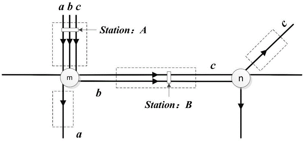
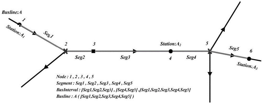
[0058] Step 1, collect all GPS track data of a bus in a time period, each group of GPS track data includes time value and longitude and latitude coordinates, utilizes longitude and latitude coordinates to determine a track point, and all track points are sorted according to time sequence;

[0059] Step 2. Perform the following calculations for all track points in turn: in the public transport road network data structure, determine at least one candidate matching road segment for a track point and form a set of candidate matching road segments, and calculate the position of the track point on each candidate matching road segment The projected points of and take the projected poin...


PUM


Abstract

The invention discloses a bus GPS track data road network matching method which includes 1 collecting all GPS track data of a bus in a period; 2 determining at least one candidate matching road section for one track point to form a candidate matching road section set in the bus road network data structure; 3 judging the candidate matching road section set of surplus track points of the first track point one by one and determining at least one matching point for each track point; 4 connecting matching points of all the track points to form multiple candidate running tracks and judging the candidate running track with the most matching points as the running track; 5 determining that each road section is matched with k track points due to the fact that the running track passes through a plurality of road sections. By means of the matching method, the GPS track points are classified into the bus road network data structure as real as possible to accurately judge the actual running position of one bus at certain time to accurately obtain the road condition information.

Description

technical field [0001] The invention relates to the traffic field, in particular to a road network matching method for bus GPS trajectory data. Background technique [0002] At present, the judgment of road condition information needs to rely on the GPS trajectory data of the bus. In the judgment process, the GPS trajectory data needs to be matched to the road network first. Floating car data is reflected on the map as discrete point elements with spatial coordinates, but it is affected by various factors in the process of GPS positioning and information transmission, map vectorization process, selection of different spatial coordinate reference systems and mutual conversion process. Most of them are dissociated from the elements of the road network line, and cannot directly analyze and process the spatial relationship with the road. Therefore, the main content of the road network matching algorithm is to assign the GPS positioning point of the floating car to a certain roa...

Claims


Application Information

Patent Timeline
Patent Type & Authority Applications(China)
IPC IPC(8): G08G1/01G08G1/123
CPCG08G1/0112G08G1/127G08G1/202
Inventor 张健钦李明轩杜明义徐志洁
Owner BEIJING UNIV OF CIVIL ENG & ARCHITECTURE
Why Eureka
Try Eureka