System and method for measuring cloud base height through combination of radiation brightness temperature and photogrammetry

A technology of cloud base height and photogrammetry, which is applied in measuring devices, height/horizontal measurement, surveying and navigation, etc. It can solve problems such as inability to calculate cloud base height, inability to accurately obtain points with the same name, poor data capture rate, etc.

Active Publication Date: 2015-03-11
CMA METEOROLOGICAL OBSERVATION CENT
View PDF2 Cites 2 Cited by
  • Summary
  • Abstract
  • Description
  • Claims
  • Application Information

AI Technical Summary

Problems solved by technology

Infrared binocular imaging surveying and mapping technology uses direct photogrammetry technology, which has high measurement accuracy, and uses infrared cameras, which are less affected by fog and haze. However, because photogrammetry technology needs to obtain the same-named points through image matching, it cannot be accurately measured when the cloud map is evenly distributed. Obtain the point with the same name, so the cloud base height cannot be calculated, and the data capture rate is poor

Method used


Image

  • System and method for measuring cloud base height through combination of radiation brightness temperature and photogrammetry
  • System and method for measuring cloud base height through combination of radiation brightness temperature and photogrammetry
  • System and method for measuring cloud base height through combination of radiation brightness temperature and photogrammetry

Examples


Embodiment Construction

[0048] The implementation of the present invention is described below through specific examples and in conjunction with the accompanying drawings, and those skilled in the art can easily understand other advantages and effects of the present invention from the content disclosed in this specification. The present invention can also be implemented or applied through other different specific examples, and various modifications and changes can be made to the details in this specification based on different viewpoints and applications without departing from the spirit of the present invention.

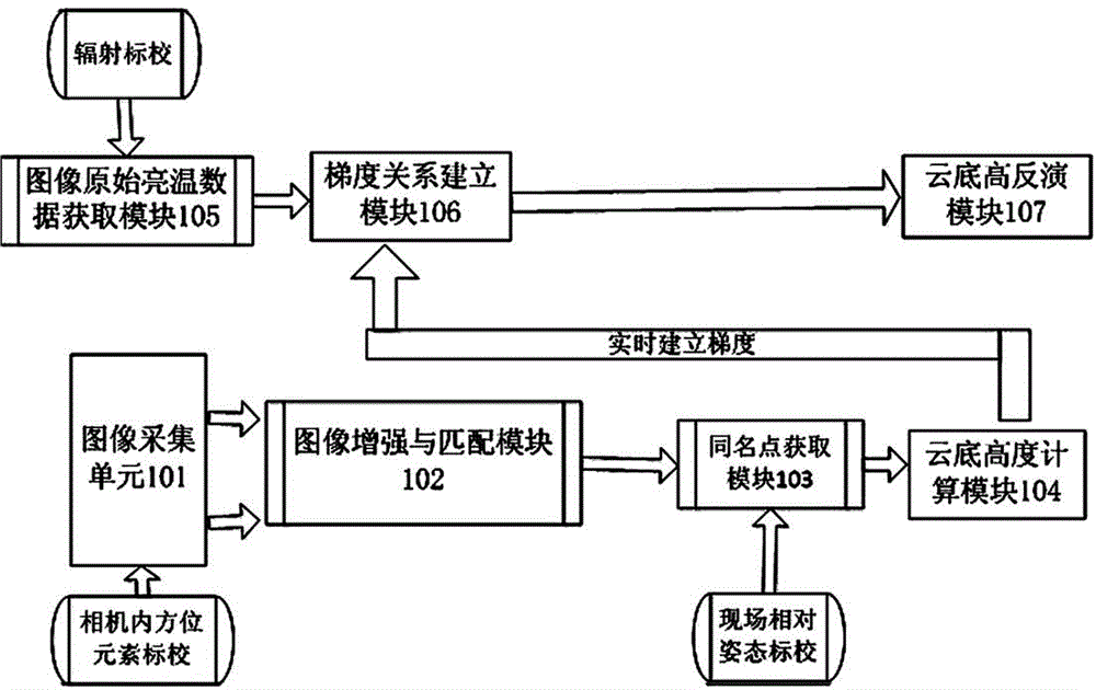
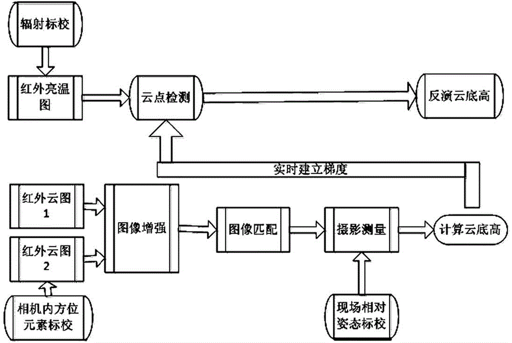
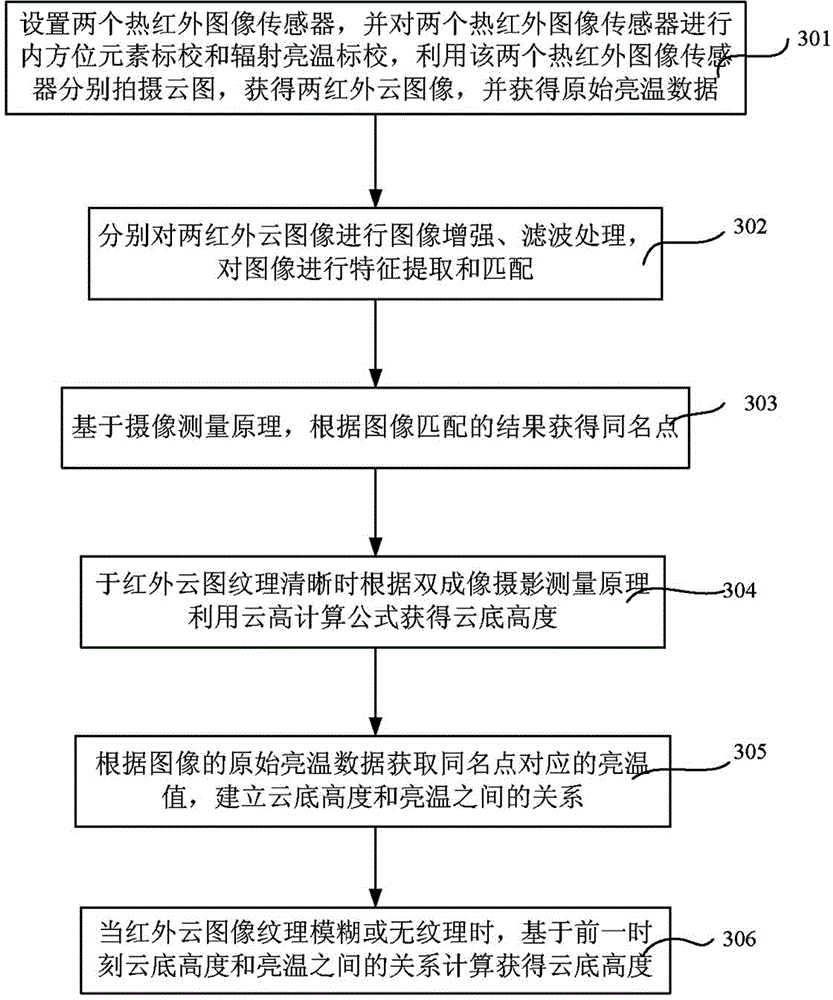
[0049] figure 1 It is a system architecture diagram of a cloud base height measurement system combining radiation brightness temperature and photogrammetry according to the present invention. Such as figure 1 As shown, a cloud base height measurement system combining radiation brightness temperature and photogrammetry in the present invention includes: image acquisition unit 101, image enh...


PUM


Abstract

The invention discloses a system and a method for measuring a cloud base height through combination of radiation brightness temperature and photogrammetry. The method comprises the following steps: calibrating interior orientation elements and radiation brightness temperatures of two thermal infrared image sensors, shooting cloud images by using the two thermal infrared image sensors respectively, and acquiring original brightness temperature data; enhancing and filtering the two infrared cloud images respectively, and extracting and matching features of the images; according to an image matching result, acquiring a homonymy point; when the infrared cloud images have clear textures, according to a double imaging photogrammetric principle, calculating to acquire the cloud base height; according to the original brightness temperature data of the images, acquiring a brightness temperature value corresponding to the homonymy point, and establishing a relationship between the cloud base height and the brightness temperature; when the infrared cloud images have fuzzy textures or no textures, based on the relationship between the cloud base height and the brightness temperature at a previous time, calculating the cloud base height. Through the system and the method, the cloud height measuring precision is ensured on the premise of reducing the fog influence and improving the data acquisition rate.

Description

technical field [0001] The invention relates to a cloud base height measurement system and method, in particular to a cloud base height measurement system and method combining radiation brightness temperature and photogrammetry. Background technique [0002] Clouds play a very important role in physical processes such as the development of weather systems, precipitation formation, and atmospheric radiation transfer. Accurate and timely acquisition of cloud information (cloud base height, cloud amount, cloud shape) is of great importance to many fields such as meteorology and civil aviation. are of great significance. However, at present, the observation of clouds in meteorological stations is still dominated by manual visual observation, and human subjective factors are large. How to accurately and effectively carry out automatic cloud observation is an important task in the field of cloud detection. [0003] At present, cloud height measurement at home and abroad is mainly...

Claims


Application Information

Patent Timeline
Patent Type & Authority Applications(China)
IPC IPC(8): G01C5/00
CPCG01C5/00
Inventor 陶法马舒庆秦勇
Owner CMA METEOROLOGICAL OBSERVATION CENT
Why Eureka
Try Eureka