InSAR (interferometric synthetic aperture radar) imaging and altitude estimation method by iterative curved surface prediction

A technology of height estimation and imaging, which is applied in the direction of measuring devices, radio wave measurement systems, radio wave reflection/reradiation, etc., and can solve problems such as terrain geometric distortion

Active Publication Date: 2015-06-10
UNIV OF ELECTRONICS SCI & TECH OF CHINA
View PDF3 Cites 22 Cited by
  • Summary
  • Abstract
  • Description
  • Claims
  • Application Information

AI Technical Summary

Problems solved by technology

However, the current back-projection algorithm is to project InSAR data onto the ground plane or radar range-azimuth plane for imaging. If the terrain

Method used


Image

  • InSAR (interferometric synthetic aperture radar) imaging and altitude estimation method by iterative curved surface prediction
  • InSAR (interferometric synthetic aperture radar) imaging and altitude estimation method by iterative curved surface prediction

Examples


Embodiment Construction

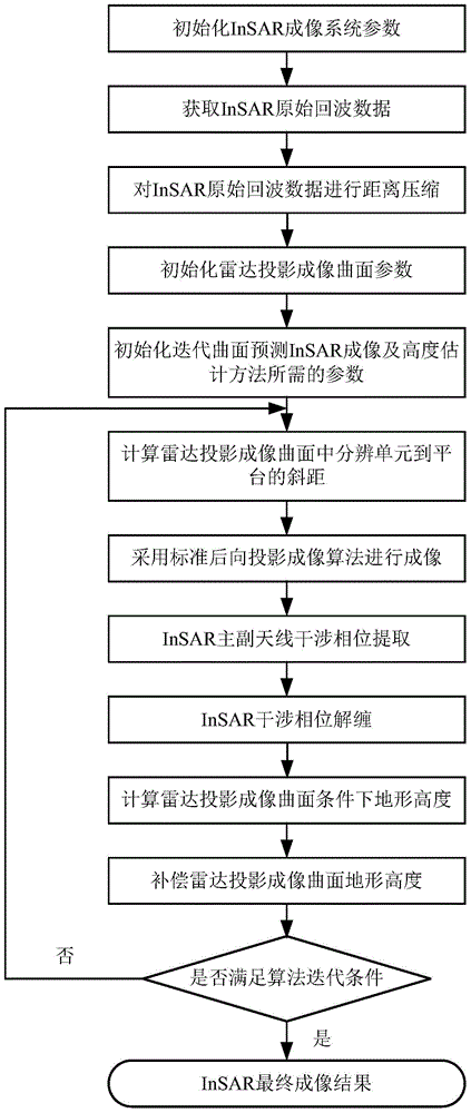
[0060] The present invention mainly adopts the method of simulation experiment to verify, and all steps and conclusions are verified correctly on MATLABR2008b software.

[0061] The specific implementation steps are as follows:

[0062] Step 1. Initialize InSAR imaging system parameters:

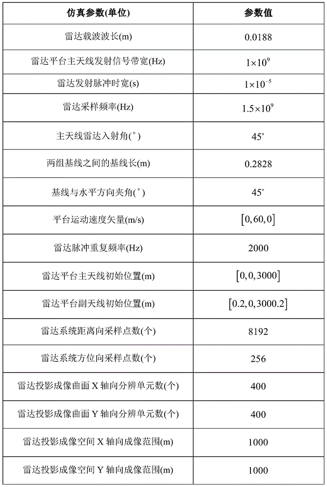
[0063] Initialize InSAR imaging system parameters, including: radar carrier wavelength λ=0.0188m, radar platform main antenna transmission signal bandwidth B=1×10 9 Hz, radar transmit pulse width T r =1×10 -5 s, radar sampling frequency F s =1.5×10 9 Hz, main antenna radar incident angle θ=45°, baseline length B between two groups of antennas l = 0.2828m, the angle between the baseline and the horizontal direction α = 45°, the radar pulse repetition frequency PRF = 2000Hz, the platform movement speed V r =[0,60,0]m / s, the number of sampling points N in the range direction of the radar system r =8192, the number of radar system azimuth sampling points N a = 256, the initial position o...


PUM


Abstract

The invention discloses an InSAR (interferometric synthetic aperture radar) imaging and altitude estimation method by iterative curved surface prediction. According to the InSAR imaging and altitude estimation method, raw echoed data of an InSAR are projected to a terrain altitude curved surface obtained from each iterative estimation to perform projection imaging by the aid of a back projection imaging algorithm so as to obtain an interferometric phase under the terrain altitude curved surface, high-altitude terrain inversion is performed by the aid of the interferometric phase, the terrain altitude curved surface is subjected to altitude compensation and multi-time iteration approximation, and the obtained terrain altitude curved surface is subjected to projection imaging and successive iteration approximation to estimate an actual terrain altitude, so that InSAR data imaging and altitude estimation integration is achieved, InSAR imaging and altitude estimation precision is improved, geometric distortion caused by terrain altitude variation is corrected, in other words, terrain geometric distortion is reduced, and a final InSAR imaging result and a final terrain altitude are obtained.

Description

technical field [0001] The invention belongs to the field of radar technology, in particular to the field of synthetic aperture radar (SAR) imaging technology. Background technique [0002] Interferometric Synthetic Aperture Radar (InSAR) is an extension of Synthetic Aperture Radar (SAR) imaging technology. It mainly uses more than two SAR images obtained by observing the same observation scene at different angles or at different time periods by more than two antennas or multiple voyages. SAR image interferometric phase information, combined with the imaging geometric relationship to invert the terrain elevation information, thus realizing the remote sensing technology of high-precision terrain three-dimensional surveying and mapping. InSAR has the advantages of large imaging area, high imaging accuracy, and all-weather and all-weather imaging. It has become an important remote sensing technology for extracting large-area surface three-dimensional images and terrain elevatio...

Claims


Application Information

Patent Timeline
IPC IPC(8): G01S13/90
CPCG01S13/9023G01S13/9017
Inventor 韦顺军张晓玲邹光浩熊海进
Owner UNIV OF ELECTRONICS SCI & TECH OF CHINA
Why Eureka
Try Eureka