Gross-error detection method of elevation anomaly data of GPS (Global Positioning System)
What is AI technical title?
AI technical title is built by PatSnap AI team. It summarizes the technical point description of the patent document.
A technology for detection of elevation anomalies and gross errors, applied in the field of geodesy, can solve problems such as multi-dimensional gross error detection and positioning difficulties, difficult realization, and misjudgment
Active Publication Date: 2015-07-15
SOUTHEAST UNIV
View PDF5 Cites 7 Cited by
Summary
Abstract
Description
Claims
Application Information
AI Technical Summary
This helps you quickly interpret patents by identifying the three key elements:
Problems solved by technology
Method used
Benefits of technology
Problems solved by technology
On the whole, it is difficult to detect and locate multi-dimensional outliers, mainly because it is difficult to determine the dimension of outliers
If multiple outliers are determined at the same time by the heuristic method, the number of combinations of the heuristics may be quite large, and it is also difficult to realize; although the one-dimensional outlier detection method is simple and feasible, it fails to consider the correlation of the influence of the outliers on the residual error, and uses it successively Judging the existence of multiple gross errors, and may also make misjudgments
Method used
Image
Click on the blue label to locate the original text in one second.
Reading with bidirectional positioning of images and text.
Examples
Embodiment 1
[0049] When describing the specific implementation process, the method of the present invention is described in detail in conjunction with a specific engineering example.
[0050] (1) Background introduction of engineering examples
[0051] To establish an area similar to the geoid, survey control points need to be laid out. In order to obtain relevant data, two surveys are required for survey control points, GPS survey and leveling survey.
[0052] ①GPS measurement: In accordance with the requirements of the national measurement specification, carry out corresponding level of GPS measurement on all control points, the purpose is to obtain the Gaussian plane coordinates and geodetic height of each control point.
[0053] ②Leveling survey: According to the requirements of national surveying regulations, conduct leveling surveys of corresponding levels on all control points, the purpose is to obtain the normal height of each control point, and calculate the elevation anomaly of...
specific Embodiment
[0066] In a specific embodiment, the 36 sets of GPS elevation anomaly data in Table 2 are substituted into the formula (15) one by one, and the matrix form of the formula (1) can be obtained. Then calculate according to formula (3), (4), (5), (6), (7) V, H, Q VV and
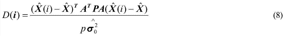
[0067] (3) According to formula (8), the Cook distance is calculated in Table 3, and D 平均 = 0.0319. Calculated D(i)-D of points 1, 4, 5, 8, 10, 15, 16, 20, 25, 30 and 35 平均 >0, so it is a strong influence point.
[0068] (4) Calculate the Welsch-Kuh distance using formula (9), see Table 3, and determine the strong influence point number according to the quantile value. It is known from Table 3 that the Welsch-Kuh distances of points 25 and 35 (those marked with *) are greater than their sub-positions (α=0.05), so points 25 and 35 are strong influence points.
[0069] Table 3 Cook distance and Welsch-Kuh distance (wk) table
[0070]
[0071] (5) The abnormal point sets obtained from the union of steps...
PUM
Abstract
The invention discloses a gross-error detection method of elevation anomaly data of GPS (Global Positioning System) and is a multi-dimensional gross-error positioning method based on anomalous points. The gross-error detection method comprises the following specific steps: (1) acquiring the data; (2) modeling by utilizing the data; (3) calculating Cook distance, and determining strong-influence-point numbers according to the average difference between the Cook distance D (i) and an average value D of all observed values; (4) calculating the wk distance and determining the strong-influence-point number according to a fractile value; (5) enabling the strong-influence-point numbers determined by the Cook distance and the Welsch-Kuh distance to form a union set, thus obtaining an anomalous point set and enabling the quantity m of the non-repeated strong-influence-point numbers as the dimension of the gross error; and (6) positioning the gross error. The gross-error detection method disclosed by the invention has the advantages that by analysis on the application results of extensive examples, when the dimension of the gross error reaches 19% of that of the total sample, the gross error can be still positioned accurately; and the gross-error detection method has important significance for improving the application quality of measurement data and has obvious social and economic values.
Description
technical field [0001] The invention relates to a gross error detection method of GPS elevation anomaly data, which belongs to the technical field of "geodesy" in the subject of "surveying and mapping science and technology". Background technique [0002] Data is the basis of scientific research, for which people use various means to obtain measurement or experimental data. Due to various reasons, the measured data is not completely consistent with the true value of the tested prototype, including measurement errors such as gross error, systematic error and accidental error. In the application of measured data, it is required that the data contain only accidental errors. Systematic errors can be discovered and corrected using certain methods. The so-called gross error detection is to detect whether the data contains gross errors, and to locate which data is the gross error. If the gross error cannot be tested and identified effectively, it will have a serious impact on th...
Claims
Application Information
Patent Timeline
Application Date:The date an application was filed.
Publication Date:The date a patent or application was officially published.
First Publication Date:The earliest publication date of a patent with the same application number.
Issue Date:Publication date of the patent grant document.
PCT Entry Date:The Entry date of PCT National Phase.
Estimated Expiry Date:The statutory expiry date of a patent right according to the Patent Law, and it is the longest term of protection that the patent right can achieve without the termination of the patent right due to other reasons(Term extension factor has been taken into account ).
Invalid Date:Actual expiry date is based on effective date or publication date of legal transaction data of invalid patent.

