An Expression Parsing Method for Constraint Checking of Attribute Values ​​in Geospatial Databases

A geospatial and analytical method technology, applied in the field of geospatial database attribute value constraint relationship inspection, can solve problems such as database analysis obstacles, inability to express attribute value constraint relationship standards, and failure to provide analytical implication logic expressions, etc., to achieve calculation time The effects of shortened time, improved internal processing capabilities, and high-efficiency technical support

Active Publication Date: 2019-06-14
SICHUAN SURVEYING & MAPPING PROD QUALITY SUPERVISION & INSPECTION STATION OF THE MINIST OF NATURAL RESOURCES SICHUAN SURVEYING & MAPPING PROD QUALITY SUPERVISION & INSPECTION STATION
View PDF6 Cites 0 Cited by
  • Summary
  • Abstract
  • Description
  • Claims
  • Application Information

AI Technical Summary

Problems solved by technology

[0004] (1) It is difficult to express a unified standard for the attribute value constraint relationship
The attribute value constraint relationship is an implied logical expression, and its form is generally "if , then ", and the SQL statement does not provide the function of parsing the implied logical expression, so it cannot be used in SQL The statement expresses the attribute value constraint relationship in a unified standard
[0005] (2) Unable to satisfy complex attribute constraint relationship checks
The SQL statement does not include arithmetic operations and complex function operations for attribute values, so it is impossible to implement constraints similar to "attribute 1+Sin(attribute 2) / attribute 3>Cos(attribute 4) and attribute 3+attribute 5 / attribute 7 >Attribute 1” also includes mathematical calculations, logic operations, relational operations, and function operations for attribute value constraint checks
[0006] In view of the problems existing in checking the constraint relationship of geospatial database attribute values ​​by relying on SQL statements, it is difficult to comprehensively, accurately and effectively check out the attribute values ​​of geospatial database that do not satisfy the constraint relationship in the process of inspection and acceptance of geospatial database. The acceptance work brings great inconvenience, and also lays serious potential obstacles for the subsequent analysis of the database

Method used


Image

  • An Expression Parsing Method for Constraint Checking of Attribute Values ​​in Geospatial Databases
  • An Expression Parsing Method for Constraint Checking of Attribute Values ​​in Geospatial Databases
  • An Expression Parsing Method for Constraint Checking of Attribute Values ​​in Geospatial Databases

Examples


Embodiment Construction

[0063] The present invention will be described in detail below in conjunction with specific embodiments. The following examples will help those skilled in the art to further understand the present invention, but do not limit the present invention in any form. It should be noted that those skilled in the art can make several changes and improvements without departing from the concept of the present invention. These all belong to the protection scope of the present invention.

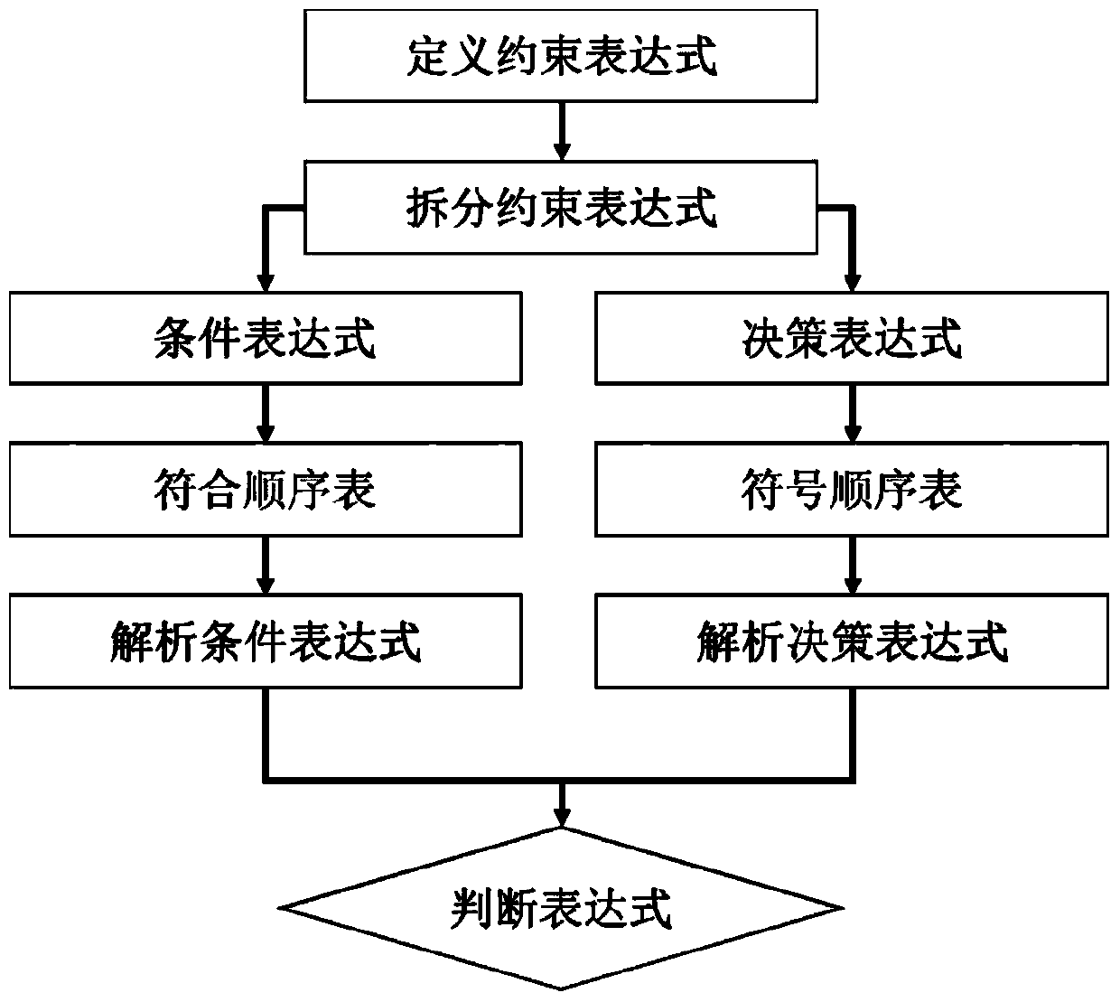
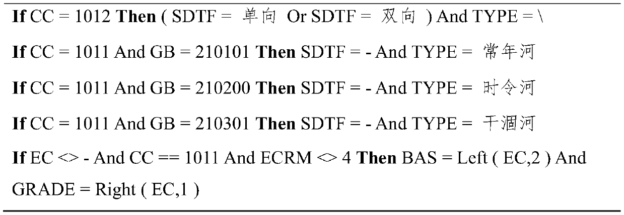
[0064] In order to solve the problems existing in checking the attribute value constraint relationship of geographic space databases relying on SQL statements, the present invention provides an expression analysis method for checking attribute value constraints of geographic space databases. The method aims at checking the constraint relationship of attribute values ​​in geospatial databases, and provides a standardized definition, analysis, calculation and judgment method for the constraint relation...


PUM


Abstract

The invention provides a method for analyzing an expression for checking an attribute value constraint relationship of a geographic space database. The method comprises the steps that 1, an attribute value constraint relationship expression is defined; 2, the attribute value constraint relationship expression is decomposed and converted; 3, the expression is analyzed; 4, the attribute value constraint relationship is judged. The method aims to check the attribute value constraint relationship of the geographic space database, defines, analyzes, calculates and judges the attribute value constraint relationship of the geographic space database in a standard mode through a logical implication expression, and therefore the attribute value constraint relationship of the geographic space database is expressed, analyzed and judged in the standard mode.

Description

technical field [0001] The present invention relates to a geospatial database attribute value constraint relationship inspection technology, in particular, an expression analysis method for geospatial database attribute value constraint inspection, especially a method for defining and analyzing geospatial data attribute value constraint relationships using expressions , Calculation and judgment techniques. Background technique [0002] Geospatial database is a major form of organizing and managing surveying and mapping geographic information products. A data table in a geospatial database is a collection of geospatial features, called a feature set. A record in the data table represents a geospatial feature, and a data column represents an attribute of the geospatial feature. There is a constraint relationship between the values ​​of each attribute of geospatial elements, that is, the value of one attribute is constrained by the value of other attributes. If the attribute...

Claims


Application Information

Patent Timeline
Patent Type & Authority Patents(China)
IPC IPC(8): G06F16/29
Inventor 李冲阳建逸邓智文黄瑞金谭理
Owner SICHUAN SURVEYING & MAPPING PROD QUALITY SUPERVISION & INSPECTION STATION OF THE MINIST OF NATURAL RESOURCES SICHUAN SURVEYING & MAPPING PROD QUALITY SUPERVISION & INSPECTION STATION
Why Eureka
Try Eureka