Radiation Simulation Method for Geostationary Satellite Ultraviolet Imaging Sensor

A geostationary satellite, ultraviolet imaging technology, applied in the field of remote sensing imaging simulation, can solve the problem of inability to provide data support for ultraviolet sensor hardware design and application processing, and achieve the effect of ensuring smooth implementation

Active Publication Date: 2018-04-27
NANJING UNIV
View PDF5 Cites 0 Cited by
  • Summary
  • Abstract
  • Description
  • Claims
  • Application Information

AI Technical Summary

Problems solved by technology

It can be seen from the above that the research and development of ultraviolet sensors in my country is still in the development period of gradual exploration. However, none of the above studies and methods can form a simulated image of the "bright ring at the edge of the earth's ultraviolet edge" of a geostationary satellite, which cannot be used for the hardware design and application of ultraviolet sensors. Processing provides data support

Method used


Image

  • Radiation Simulation Method for Geostationary Satellite Ultraviolet Imaging Sensor
  • Radiation Simulation Method for Geostationary Satellite Ultraviolet Imaging Sensor
  • Radiation Simulation Method for Geostationary Satellite Ultraviolet Imaging Sensor

Examples


Embodiment Construction

[0030] The present invention will be described in detail below according to the accompanying drawings, so as to make the technical route and operation steps of the present invention clearer.

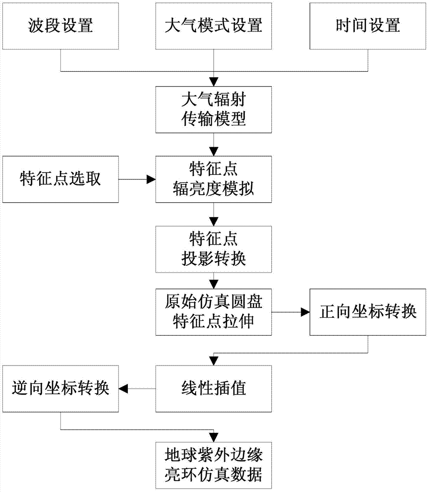
[0031] like figure 1 As shown, it is a flowchart of a radiation simulation method for a geostationary satellite ultraviolet imaging sensor in an embodiment of the present invention, including the following steps:

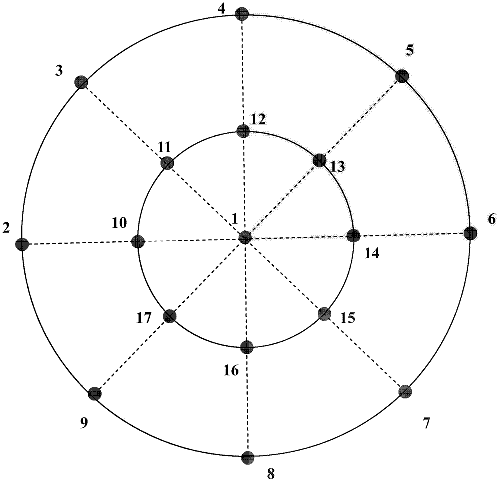
[0032] The first step, the acquisition of the ultraviolet radiance value of the feature point - such as figure 2 As shown in Fig. 1, using the geosynchronous satellite as a platform, select four positions relative to the sub-satellite point, up, down, left, and right, and the limb point, the sub-satellite point, and the middle point between the limb point and the sub-satellite point where the straight line with an inclination angle of ±45º intersects the earth As the surface feature points (there are 17 surface feature points), the vertically upward points of each edge point...


PUM


Abstract

The invention relates to a radiation simulation method for a geostationary satellite ultraviolet imaging sensor, which is based on the preliminary analysis of the existence and characteristics of the "Earth's Ultraviolet Edge Bright Ring", setting the waveband range to 330-360nm, for the "Earth's Ultraviolet Edge Bright Ring" "Bright Ring" to perform radiance simulation and batch generate UV simulation images at any point in time. The main steps include: the acquisition of the ultraviolet radiation brightness value of the feature point; the projection conversion of the feature point on the imaging plane; the generation of complete simulation data. The radiation simulation method of the geostationary satellite ultraviolet imaging sensor of the present invention can batch and quickly generate simulation data of "bright rings at the edge of the earth's ultraviolet light" in different observation modes within a specified time range (time point or time period), so as to ensure sensitive The smooth implementation of device development.

Description

technical field [0001] The invention relates to remote sensing imaging simulation, in particular to a radiation simulation method for an ultraviolet imaging sensor of a geostationary satellite. Background technique [0002] The spacecraft autonomous navigation system can determine the position and speed of the spacecraft in real time on-orbit with little or no support from the ground system, realize autonomous operation, and greatly improve the survivability and safety performance of the satellite system. As a more reasonable and optimal choice for autonomous navigation of spacecraft, ultraviolet imaging sensors have received keen attention at home and abroad. The development of the ultraviolet imaging sensor needs to analyze and summarize the ultraviolet characteristics of the earth, that is, the distribution law of the "bright ring of the earth's ultraviolet edge", so as to provide data input for the hardware design of the camera and the system development of application p...

Claims


Application Information

Patent Timeline
Patent Type & Authority Patents(China)
IPC IPC(8): G06F17/50
Inventor 田庆久林英豪吕春光
Owner NANJING UNIV
Why Eureka
Try Eureka