Method based on satellite communication for identifying deception jamming acting on navigation data of unmanned plane

A technology of navigation data and identification method, applied in satellite radio beacon positioning system, navigation, navigation and other directions through speed/acceleration measurement, which can solve the problems of inability to know the exact position of the aircraft, inability to distinguish position changes, position deviation, etc.

Active Publication Date: 2016-01-13
BEIHANG UNIV
View PDF5 Cites 20 Cited by
  • Summary
  • Abstract
  • Description
  • Claims
  • Application Information

AI Technical Summary

Problems solved by technology

If the airborne navigation data is subject to deceptive interference, such as interference with the airborne satellite navigation data, when the interference adopts progressive interference, even the inertial navigation with integrated navigation cannot distinguish the position caused by the flight of the UAV. change, or positional deviation due to spoofing interference
After the

Method used


Image

  • Method based on satellite communication for identifying deception jamming acting on navigation data of unmanned plane
  • Method based on satellite communication for identifying deception jamming acting on navigation data of unmanned plane
  • Method based on satellite communication for identifying deception jamming acting on navigation data of unmanned plane

Examples


Embodiment Construction

[0021] The present invention will be further described in detail below with reference to the drawings and embodiments.

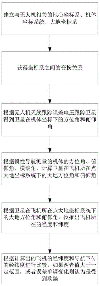
[0022] The present invention is a method for identifying deception of UAV navigation data based on satellite communication, such as figure 1 As shown, including the following steps:

[0023] Step 1: Establish the geocentric coordinate system, airframe coordinate system, and geodetic coordinate system related to the UAV;

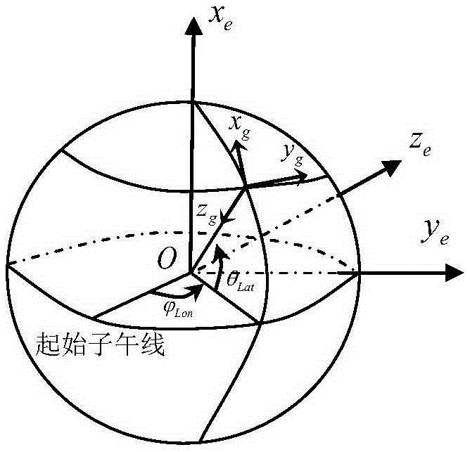
[0024] Let the longitude and latitude of the aircraft be θ LatJ , The longitude of the satellite Earth radius R e , The height from the aircraft to the ground is h, the height from the satellite to the ground is H, and the distance from the satellite to the aircraft is D.

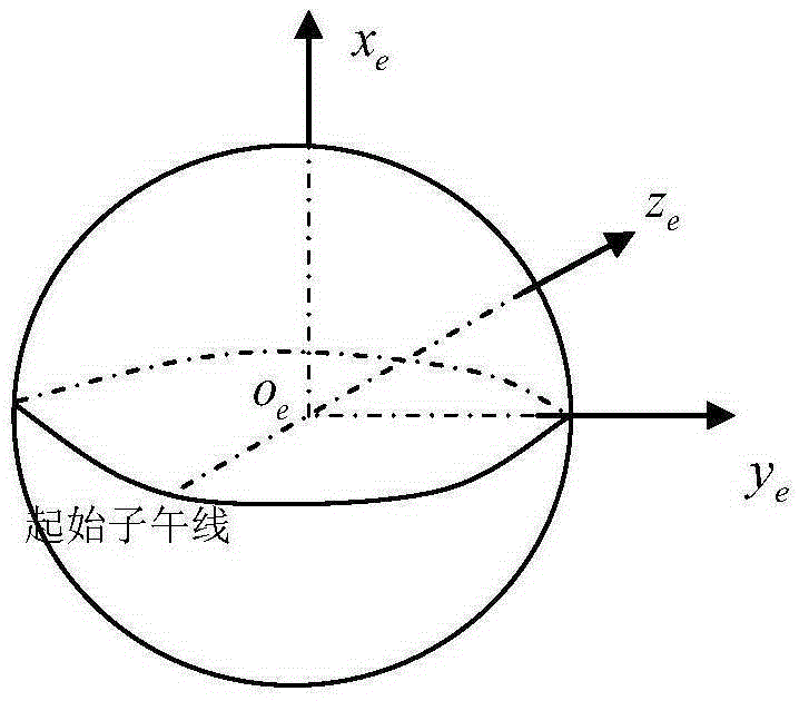
[0025] Let the geocentric coordinate system be O(x e ,y e ,z e ),Such as figure 2 Shown, where O e The origin is the center of the earth, x e The axis passes through the center of the earth and points to true north, y e The axis passes through the center of the earth and poi...


PUM


Abstract

The invention discloses a method based on satellite communication for identifying deception jamming acting on navigation data of an unmanned plane. The method comprises the steps: firstly, establishing a geocentric coordinate system, a plane body coordinate system and a geodetic coordinate system associated with an unmanned plane; secondly, obtaining transformation relations among the coordinate systems; thirdly, obtaining the azimuth and the pitch angle of a satellite in the plane body coordinate system in a way that an unmanned plane antenna tracks the satellite according to error voltages generated during tracking of the antenna; fourthly, calculating the geodetic azimuth and the pitch angle of the satellite in a point where the geodetic coordinate system of the plane is located according to the azimuth, the pitch angle and the roll angle of the plane measured through inertial navigation; and deducing a longitude [phi]Lon and a latitude [theta]Lat of the plane according to the geodetic azimuth and the pitch angle of the satellite in the point where the geodetic coordinate system of the plane is located. The method can identify whether navigation data is deceptive by means of an existing satellite communication system with no need of other auxiliary devices.

Description

Technical field [0001] The invention relates to a method for identifying deception of UAV navigation data based on satellite communication, and belongs to the technical field of UAV navigation anti-deception technology. Background technique [0002] UAVs are smart devices. Since no one is on the UAV, the ground depends entirely on the navigation data carried by the receiver to determine the specific location of the UAV. Commonly used UAVs use a combination of inertial navigation and satellite navigation for navigation. . The inertial navigation is not susceptible to interference and the high precision of satellite navigation can be used to provide high precision and stable position navigation data. If the airborne navigation data is deceptively interfered, such as jamming the airborne satellite navigation data, when the interference uses progressive interference, even the inertial navigation system using integrated navigation cannot distinguish the position caused by the flight ...

Claims


Application Information

Patent Timeline
IPC IPC(8): G01S19/21G01S19/47G01C21/16G01C21/20
CPCG01C21/165G01C21/20G01S19/21G01S19/47
Inventor 曾国奇向锦武赵民强
Owner BEIHANG UNIV
Why Eureka
Try Eureka