
A method and device for monitoring the collapse of farm buildings in earthquake-stricken areas

A technology for rural houses and disaster areas, applied in special data processing applications, instruments, electrical digital data processing, etc., can solve problems such as the difficulty in the number of farm house collapses and the difficulty in obtaining high-resolution remote sensing data

Inactive Publication Date: 2018-08-31
MIN OF CIVIL AFFAIRS NAT DISASTER REDUCTION CENT +1
View PDF2 Cites 0 Cited by
  • Summary
  • Abstract
  • Description
  • Claims
  • Application Information

AI Technical Summary

Problems solved by technology

However, when a major earthquake occurs, it is difficult to obtain high-resolution remote sensing data covering the entire earthquake-stricken area at the first time, which makes it very difficult to determine the number of farm buildings in the entire disaster area.

Method used


Image

  • A method and device for monitoring the collapse of farm buildings in earthquake-stricken areas
  • A method and device for monitoring the collapse of farm buildings in earthquake-stricken areas
  • A method and device for monitoring the collapse of farm buildings in earthquake-stricken areas

Examples


Embodiment Construction

[0013] Specific embodiments of the present invention will be described in detail below in conjunction with the accompanying drawings. It should be understood that the specific embodiments described here are only used to illustrate and explain the present invention, and are not intended to limit the present invention.

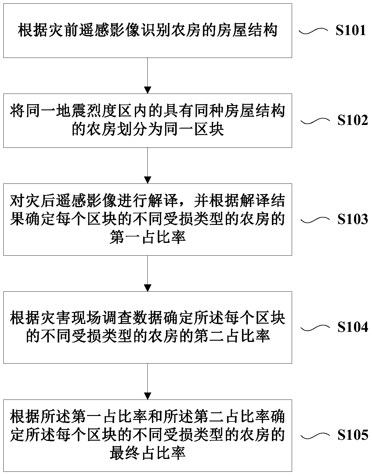
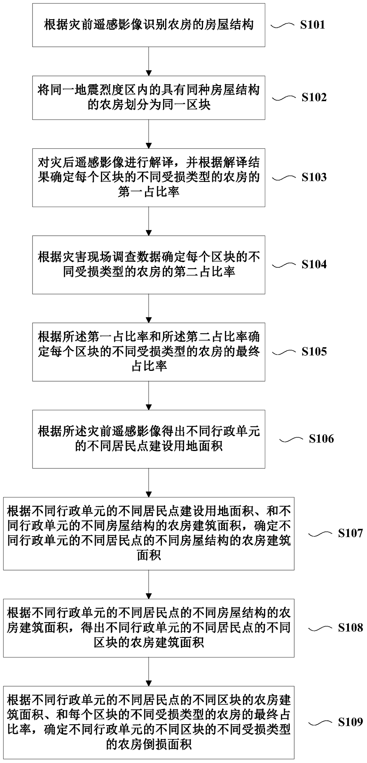
[0014] figure 1 A flow chart of a method for monitoring collapse of farm buildings in earthquake-stricken areas according to an embodiment of the present invention is shown. Such as figure 1 As shown, the method may include: Step S101, identifying the structure of the farmhouse according to the pre-disaster remote sensing images; Step S102, dividing the farmhouses with the same house structure in the same seismic intensity area into the same block; Step S103, Interpret the post-disaster remote sensing images, and determine the first proportion of different damaged types of farm houses in each block according to the interpretation results; step S104, determine ...


PUM


Abstract

The invention discloses a method and equipment for monitoring fall damage of farm houses in an earthquake stricken area. The method comprises the following steps of identifying house structures of the farm houses according to remote-sensing images before the disaster; dividing the farm houses with the same house structure in the same seismic intensity area into the same block; interpreting remote-sensing images after the disaster and determining a first ratio of the farm houses of different damage types in each block according to an interpreted result; determining a second ratio of the farm houses of different damage types in each block according to survey data of a disaster scene; and determining a final ratio of the farm houses of different damage types in each block according to the first ratio and the second ratio. According to the method and the equipment, the damage condition of the farm houses in the disaster area can be more objectively and accurately mastered, and the damage condition of the farm houses in the whole disaster area can be mastered by utilizing the incomplete remote-sensing data especially under the condition that the remote-sensing data cannot cover the whole disaster area.

Description

technical field [0001] The invention relates to the field of earthquake disaster loss assessment, in particular to a method and equipment for monitoring collapse of farm buildings in earthquake-stricken areas. Background technique [0002] The frequent occurrence of earthquakes in our country has caused a large number of farm houses to collapse, causing huge loss of life and property in rural areas, and seriously affecting the sustainable development of society. The number of farm house collapses is an important part of the comprehensive earthquake loss assessment and an important basis for national disaster relief and reconstruction. [0003] At present, local reported data and field survey data are usually used to determine the number of farm house collapses. However, this method that only relies on human investigation often has the problem of being unable to obtain real data at the first time due to the interruption of traffic and communication in the disaster area. [...

Claims


Application Information

Patent Timeline
Patent Type & Authority Patents(China)
IPC IPC(8): G06F17/30
Inventor 杨思全范一大和海霞刘明黄河聂娟王平李仪刘亮
Owner MIN OF CIVIL AFFAIRS NAT DISASTER REDUCTION CENT
Learn More