Geographic information based three-dimensional application system

A geographic information and application system technology, applied in the field of 3D application systems based on geographic information

Active Publication Date: 2016-06-22
星际空间(天津)科技发展有限公司
View PDF3 Cites 26 Cited by
  • Summary
  • Abstract
  • Description
  • Claims
  • Application Information

AI Technical Summary

Problems solved by technology

However, in the rendering process, there will be technical problems such as geographic information data processing, spatial data retrieval and analysis, massive data scheduling, and model texture sharing that need to be resolved and processed.
[0008] At present, there is no perfe

Method used


Image

  • Geographic information based three-dimensional application system
  • Geographic information based three-dimensional application system
  • Geographic information based three-dimensional application system

Examples


Embodiment 1

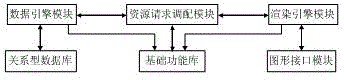
[0052] figure 1 A schematic structural diagram of a three-dimensional application system based on geographic information provided in this embodiment. As shown in the figure, a three-dimensional application system based on geographic information is composed of a data engine module, a resource request allocation module, and a rendering engine module as the main body, and is assisted by a relational database, a basic function library, and a graphical interface module. a complete system. Among them: the data engine module is used to manage spatial data containing geographic information, supports multiple users to access and operate database data concurrently, and provides spatial data organization, retrieval and analysis; resource request allocation module allocates request resources for different threads, and Query and obtain data from the data engine module, the data engine module returns the queried index data and entity object data to the resource request allocation module, ...


PUM


Abstract

The invention discloses a geographic information based three-dimensional application system and relates to the technical field of geographic information processing and display. The system is characterized by being composed of a data engine module, a resource request allocation module and a rendering engine module which serve as a main body; and the system is a complete system assistantly composed of a relational database, a basic function library and a graphic interface module. The problems in geographic information data based management, spatial data organization, retrieval and analysis, three-dimensional scene organization and management, efficient massive data dispatching, model and texture sharing, quick three-dimensional simulation display of geographic information data and the like can be effectively solved. Meanwhile, the system can be expanded to various different application fields for more professional and effective applications.

Description

technical field [0001] The present invention relates to the technical field of geographic information, in particular to management based on geographic information data, spatial data organization, retrieval and analysis, organization and management of three-dimensional entity objects, efficient scheduling of massive data and sharing of models and textures, and geographic information data A 3D application system based on geographical information for 3D simulation application. Background technique [0002] Geographic Information System (Geographic Information System or Geo-Information system, GIS) is sometimes called "geographic information system" or "resource and environmental information system". It is a specific and very important spatial information system. It is a technical system that collects, stores, manages, calculates, analyzes, displays and describes the relevant geographical distribution data in the space of the entire or part of the earth's surface (including the...

Claims


Application Information

Patent Timeline
IPC IPC(8): G06F17/30
Inventor 江贻芳沈迎志高健蔡红沈美岑周新鹤辛全波王梦
Owner 星际空间(天津)科技发展有限公司
Why Eureka
Try Eureka