
Satellite borne SAR digital beam forming formation method based on sparse spatial spectrum estimation

A sparse space, digital beam technology, applied in the field of radar, can solve the problems of SNR loss of SAR images, the performance degradation of direction of arrival estimation, etc., and achieve the effect of ensuring the receiving gain

Inactive Publication Date: 2016-07-20
UNIV OF ELECTRONIC SCI & TECH OF CHINA
View PDF6 Cites 11 Cited by
  • Summary
  • Abstract
  • Description
  • Claims
  • Application Information

AI Technical Summary

Problems solved by technology

These methods all use the subspace direction finding method to improve the influence of terrain fluctuations, but the subspace direction finding method is affected by the number of samples
When the number of samples is small, the estimation performance of the direction of arrival will be greatly reduced, resulting in the loss of the SNR of the SAR image

Method used


Image

  • Satellite borne SAR digital beam forming formation method based on sparse spatial spectrum estimation
  • Satellite borne SAR digital beam forming formation method based on sparse spatial spectrum estimation
  • Satellite borne SAR digital beam forming formation method based on sparse spatial spectrum estimation

Examples


Embodiment Construction

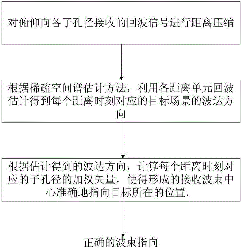
[0016] Refer to attached figure 1 , the specific implementation steps of the present invention are as follows:

[0017] Step 1, performing distance compression on the echo signals received from the elevation to each sub-aperture.

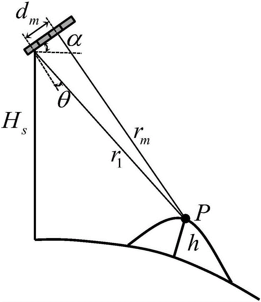
[0018] Assuming that the SAR system is divided into M uniformly distributed sub-apertures along the elevation direction, as shown in the attached figure 2 shown, where H s is the height of the satellite platform, d m Indicates the distance from the mth sub-aperture to the first sub-aperture, α is the horizontal inclination angle of the antenna, r 1 and r m respectively represent the slant distances from the ground target P to the first and m sub-apertures, h is the altitude of the target P, θ is the angle between the line connecting the slant distances from the target to the first sub-aperture and the normal line of the antenna panel, and its value Upwards away from the antenna normal is positive, and downwards is negative, which can be calcul...


PUM


Abstract

The present invention discloses a satellite borne SAR digital beam forming formation method based on sparse spatial spectrum estimation. The problem is mainly solved that the receiving gain is lost caused by the influence of small sample constraint in the prior art. The method comprises: (1) performing distance compression of echo signals received by each subaperture in the pitching direction; (2) obtaining the echo direction of an object scene corresponding to each distance moment through estimation of the echo of each distance unit according to the sparse spatial spectrum estimation method; and (3) calculating the weighted vector of the subaperture corresponding to each distance moment according to the echo direction obtained through estimation to allow a formed received wave beam center to accurately point to the position where the object scene is located. The satellite borne SAR digital beam forming formation method based on sparse spatial spectrum estimation is configured to convert an object scene elevation estimation problem to a sparse spatial spectrum estimation problem to realize the correct beam pointing and ensure the received gain of the echo signals.

Description

technical field [0001] The invention belongs to the field of radar technology, and further relates to a spaceborne synthetic aperture radar (Synthetic Aperture Radar, SAR) digital beamforming (Digital Beamforming, DBF) method in the field of radar imaging technology. Background technique [0002] Synthetic aperture radar has been widely used in military and civilian fields such as strategic defense and terrain surveying and mapping because of its all-day, all-weather, and long-range imaging capabilities. Among them, combining with Digital Beamforming (DBF) and using elevation beam scanning (SCan-On-REceive, SCORE) technology to improve the system Signal to Noise Ratio (SNR) has become one of the research hotspots of modern radar. [0003] SCORE technology sets multiple sub-apertures at the receiving end in the elevation direction, and performs time-varying weighting processing on them to form an equivalent high-gain narrow beam to track the received echo. Under the assumpti...

Claims


Application Information

Patent Timeline
IPC IPC(8): G01S13/90
CPCG01S13/90G01S13/904
Inventor 杨桃丽淦小健王勇
Owner UNIV OF ELECTRONIC SCI & TECH OF CHINA
Learn More