Land automatic classification method based on multisource and multi-temporal satellite image data

A technology of satellite imagery and automatic classification, applied to instruments, character and pattern recognition, computer components, etc., can solve problems such as time limitation, incomplete vertical time, and impact on land evolution analysis, so as to speed up classification and reduce land area Effect

Inactive Publication Date: 2016-08-03
王伟 +4
View PDF5 Cites 4 Cited by
  • Summary
  • Abstract
  • Description
  • Claims
  • Application Information

AI Technical Summary

Problems solved by technology

However, the data in it are only three years of land ecological classification data in 2000, 2005 and 2010, and the longitudinal time is not complete
The complete data of land classification is of great significance for the analysis of land evolution. Due to the limited time of the existing land classification results data, it is impossible to obtain co

Method used


Image

  • Land automatic classification method based on multisource and multi-temporal satellite image data
  • Land automatic classification method based on multisource and multi-temporal satellite image data
  • Land automatic classification method based on multisource and multi-temporal satellite image data

Examples


Embodiment Construction

[0036] In order to make the object, technical solution and advantages of the present invention clearer, various embodiments of the present invention will be described in detail below in conjunction with the accompanying drawings. However, those of ordinary skill in the art can understand that, in each implementation manner of the present invention, many technical details are provided for readers to better understand the present application. However, even without these technical details and various changes and modifications based on the following implementation modes, the technical solution claimed in each claim of the present application can be realized.

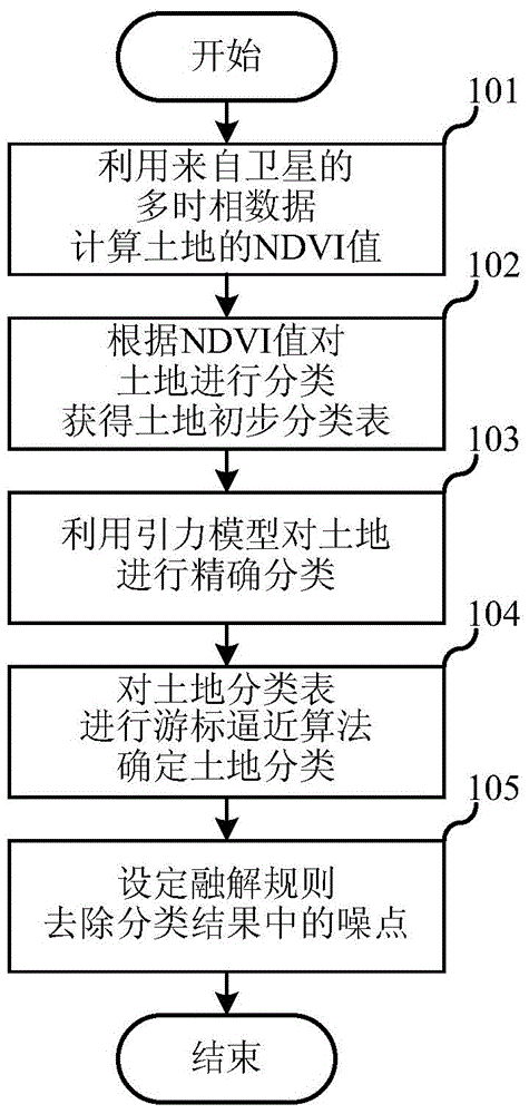
[0037] The first embodiment of the present invention relates to a land automatic classification method based on multi-source multi-temporal satellite image data, the process of which is as follows figure 1 As shown, the details are as follows:

[0038] Step 101, using multi-temporal data from satellites to calculate the NDV...


PUM


Abstract

The invention relates to the field of ecological environment, and discloses a land automatic classification method based on multisource and multi-temporal satellite image data. The method comprises the following steps: A, multi-temporal data from the satellite are used for calculating a normalized differential vegetation index (NDVI) value of the land; B, according to the NDVI value, land classification baseline data are predicted to divide and classify the land, and a land initial classification table is acquired; and C, a gravity model and the land initial classification table are used for precisely classifying the land, and a land classification result is acquired. As the multi-temporal data serving as a data source has an exact time point, when the land automatic classification method in the embodiment of the invention is used, land automatic classification complete data in a specific temporal scale are acquired through processing the multi-temporal data at different time points, and evolution analysis of the land is facilitated.

Description

technical field [0001] The invention relates to the field of ecological environment, in particular to an automatic land classification method based on multi-source multi-temporal satellite image data. Background technique [0002] Land use and land cover are not only the way humans use natural space in a certain region, but also involve changes in the natural ecological environment on a global scale. Changes in land use patterns have profound impacts on climate, air, biodiversity, soil and other environmental factors. In the change of land use and land cover, human activities are one of the main influencing factors, especially in today's rapid development of social civilization, human social and economic activities play a leading role around towns and even remote suburbs far away from towns. [0003] The current land use and land cover research mainly includes three aspects: the driving factors of land use and land cover change, the dynamic analysis of land use and land cov...

Claims


Application Information

Patent Timeline
IPC IPC(8): G06K9/62
Inventor 王伟金陶陶赵越凌焕然鲁逸
Owner 王伟
Why Eureka
Try Eureka