Method for constructing multidimensional attribute visual generalized model considering spatial position

A technology of multi-dimensional attributes and spatial location, applied in the field of building generalized models of multi-dimensional attribute visualization, can solve problems such as few studies, and achieve the effect of strong generality

Inactive Publication Date: 2016-09-28
NINGBO INST OF TECH ZHEJIANG UNIV ZHEJIANG
View PDF4 Cites 7 Cited by
  • Summary
  • Abstract
  • Description
  • Claims
  • Application Information

AI Technical Summary

Problems solved by technology

In fact, the "Jordan Curve Theorem" is also an important theorem in traditional topology, and traditional topology has always recognized that the study of embedded spaces is very valuable, which can be learned from manifolds (such as one-dimensional manifolds 1-manifold, two-dimensional Manifold 2-manifold, three-dimensional man...

Method used


Image

  • Method for constructing multidimensional attribute visual generalized model considering spatial position
  • Method for constructing multidimensional attribute visual generalized model considering spatial position
  • Method for constructing multidimensional attribute visual generalized model considering spatial position

Examples


Embodiment Construction

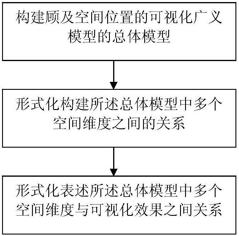
[0046] In the present invention, it is considered that it is very important to consider three kinds of spatial forms or spatial environments, i.e., the object's own spatial form, the embedded spatial environment, and the spatial perspective of the observation mode, when the multi-dimensional information (carrying the spatial position) is visualized. . Therefore, in the present invention, a multi-dimensional information visualization generalized model construction method considering the spatial position is proposed, which specifically includes the following three major steps as follows: figure 1 Shown: Step 1 builds the overall model of the visualized generalized model taking into account the spatial position, Step 2 formalizes the relationship between multiple spatial dimensions in the overall model, and Step 3 formally expresses the relationship between multiple spatial dimensions in the overall model and the visualization effect relation. Among them, the focus is on the fo...


PUM


Abstract

The invention relates to the field of geographic information modeling and visualization, and discloses a method for constructing a multidimensional attribute visual generalized model considering a spatial position. The method comprises the following specific steps of constructing an overall model of the visual generalized model considering the spatial position; establishing a relationship among a plurality of spatial dimensions in the overall model in a formalized manner; and expressing relationships between the spatial dimensions in the overall model and a visual effect in a formalized manner. The method has the advantages that the universality of an object and a really-existent constraint are considered in the constructed overall model, then an impossibly and really existent situation is eliminated in the establishment of the relationship among the spatial dimensions, and finally the spatial dimensions and the visual effect are expressed in the formalized manner to obtain the multidimensional attribute visual generalized model with very high universality.

Description

technical field [0001] The invention relates to the field of geographic information modeling and visualization, in particular to a method for constructing a multi-dimensional attribute visualization generalized model taking into account spatial positions. technical background [0002] Visualization research originated from Visualization in Scientific Computing (ViSC, Visualization in Scientific Computing), which was proposed by the National Natural Science Foundation of America in 1987. In the visualization research of data and information, the visualization of high-dimensional and multi-dimensional data and information has always been the research focus (Kraark, M.J. (2003). Geovisualization Illustrated. ISPRS Journal of Photogrammetry & Remote Sensing, 57:390-399). It is involved in many disciplines and fields, including visualization of biological data, visualization of social media data, visualization of multimedia information, visualization of socioeconomic data, etc. ...

Claims


Application Information

Patent Timeline
IPC IPC(8): G06F17/30
CPCG06F16/26G06F16/283
Inventor 虞昌彬郭仁忠杜清运李霖杨建刚庞超逸贺彪赵志刚
Owner NINGBO INST OF TECH ZHEJIANG UNIV ZHEJIANG
Why Eureka
Try Eureka