Reference elliptical projection plane coordinate system converting method based on identical central project longitude

A technology of projection plane and coordinate system, applied in the field of coordinate system conversion of different reference ellipsoid projection planes, can solve the problem of poor accuracy of four-parameter conversion model, and achieve the effect of reducing difficulty and improving calculation accuracy and speed

Inactive Publication Date: 2016-09-28
福州市勘测院有限公司
View PDF2 Cites 2 Cited by
  • Summary
  • Abstract
  • Description
  • Claims
  • Application Information

AI Technical Summary

Problems solved by technology

[0003] In view of this, the purpose of the present invention is to propose a method for converting coordinate systems of different reference ellipsoid projection planes that takes into account the same central projection meridian, which facilitates the conversion of geographic spatial data coordinate systems, reduces the difficulty of conversion techniques, and solves the problems of ordinary two-dimensional planes. The problem of poor accuracy of the similarity transformation four-parameter transformation model

Method used


Image

  • Reference elliptical projection plane coordinate system converting method based on identical central project longitude
  • Reference elliptical projection plane coordinate system converting method based on identical central project longitude
  • Reference elliptical projection plane coordinate system converting method based on identical central project longitude

Examples


Embodiment Construction

[0020] The present invention will be further described below in conjunction with the accompanying drawings and embodiments.

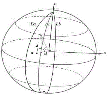
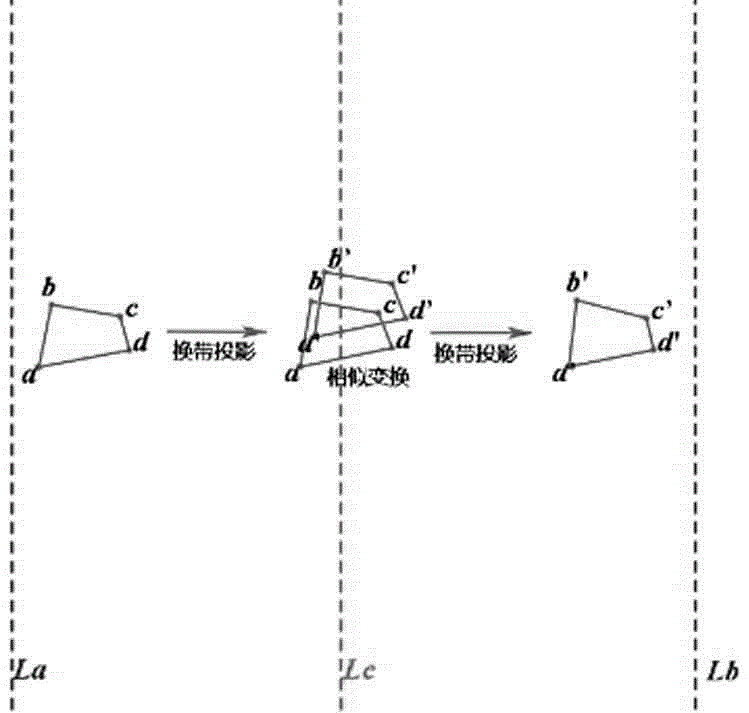
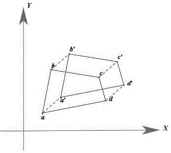
[0021] This embodiment provides a conversion method for different reference ellipsoid projection plane coordinate systems taking into account the same central projection meridian, and specifically provides two reference ellipsoid projection plane coordinate systems: A reference ellipsoid projection plane coordinate system, B reference ellipsoid projection Plane coordinate system, wherein, the Gaussian projection central meridian of A reference ellipsoid projection plane coordinate system is L a , B refers to the central meridian of the Gaussian projection plane coordinate system of the ellipsoidal projection as L b ; also includes the following steps:

[0022] Step S1: Select the central meridian of the geographic range of the data area, and set the unified meridian value L c , calculated based on the uniform meridian value L c The similarity transfo...


PUM


Abstract

The invention relates to a reference elliptical projection plane coordinate system converting method based on identical central project longitude. First, an A reference elliptical projection plane coordinate system is converted to a B system based on the identical central project longitude through similarity transformation. Then, calculation to convert projection zone is made on the elliptical parameters in the B system for obtaining a required longitude plane coordinate system. According to the invention, geographic space data coordinate system conversion is facilitated, conversion technical difficulty is reduced and a problem of poor precision of a similarity transformation four parameter conversion model in a common two-dimensional plane is solved.

Description

technical field [0001] The invention relates to the data processing field of surveying and mapping geographic space coordinate system conversion, in particular to a conversion method of different reference ellipsoid projection plane coordinate systems considering the same central projection meridian. Background technique [0002] At present, with the popularization and use of the CGCS2000 coordinate system, most of the existing urban coordinate systems are established based on the 1954 Beijing coordinate system and the 1980 Xi’an coordinate system. Frequent conversion between them is required, and the GPS measurement and navigation system needs to carry out WGS1984 to the data results and other needs. coordinate system for conversion. The calculation model generally used for the conversion between different ellipsoids is the seven-parameter similarity transformation model, which is based on the conversion of the geodetic coordinates into a three-dimensional space Cartesian c...

Claims


Application Information

Patent Timeline
Patent Type & Authority Applications(China)
IPC IPC(8): G06T3/20
CPCG06T3/20
Inventor 高昭良包忠聪
Owner 福州市勘测院有限公司
Why Eureka
Try Eureka