Landslide hazard monitoring system and method

A monitoring system and disaster technology, applied in signal transmission systems, forecasting, measurement devices, etc., can solve problems such as inability to guarantee accuracy, complex and diverse disaster-causing factors for loess landslides, and unknown disaster-pregnancy mechanisms and developmental laws, so as to reduce disaster losses. Effect

Inactive Publication Date: 2016-09-28
CHANGAN UNIV
View PDF6 Cites 16 Cited by
  • Summary
  • Abstract
  • Description
  • Claims
  • Application Information

AI Technical Summary

Problems solved by technology

[0002] my country's loess area is about 630,000 km 2 , accounting for about 6.6% of the country's land area, and loess landslides are the most common geological disasters in loess, with hundreds of landslides occurring every year. Statistics show that there have been 1,131 loess landslides in Shaanxi Province and more than 1,300 in Lanzhou. , 4,576 places in eastern Gansu Province, due to the special structure of loess and its sensitivity to water, how to reduce the losses caused by it has become a national problem. With the development of economy, the number of large-scale projects in the west has increased, and loess landslides The monitoring and early warning has attracted the attention of government departments and relevant scientific researchers, and its monitoring and early warning work is in the exploratory stage. Many scientific researchers are also committed to the research of monitoring and forecasting loess landslides. Some scholars have realized loess landslide monitoring based on GPRS wireless transmission. on this basis, some scholars have used GIS, GPS, 3S and other advanced technologies to realize the analysis, prediction and management of geological disasters. Early warning and forecasting is very difficult, and it is still in the exploration stage. It is difficult to achieve stable long-distance and long-term monitoring, and the accuracy cannot be guaranteed

Method used


Image

  • Landslide hazard monitoring system and method
  • Landslide hazard monitoring system and method
  • Landslide hazard monitoring system and method

Examples


Embodiment Construction

[0030] Below in conjunction with accompanying drawing, the present invention is described in further detail:

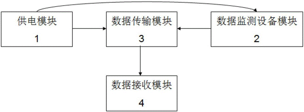
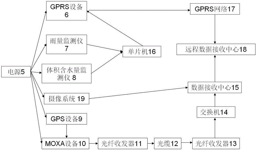
[0031] Such as Figure 1 to Figure 4 As shown, the present invention provides a landslide disaster monitoring system, comprising a data monitoring equipment module 2, the data monitoring equipment module 2 is connected with a data transmission module 3, and the data transmission module 3 and the data monitoring equipment module 2 are all connected with the power supply module 1 , the data transmission module 3 is connected with a data receiving module 4, wherein: the data monitoring equipment module 2 includes a rainfall monitor 7, a volumetric moisture monitor 8, a GPS device 9, and a camera system 19. The power supply module 1 includes a power supply 5 . Data transmission module 3 comprises single-chip microcomputer 16, GPRS equipment 6, MOXA equipment 10, single-chip microcomputer 16 links to each other with GPRS equipment 6, GPRS equipment 6 links to each other w...


PUM


Abstract

The invention discloses a landslide hazard monitoring system and method. The system comprises a data monitoring equipment module. The data monitoring equipment module is connected with a data transmission module; the data transmission module is connected with a data reception module; and the data transmission module and the data monitoring equipment module are connected with a power supply module for supplying power therefor. The data monitoring equipment module comprises a rainfall monitor for monitoring rainfall, a volumetric water content monitor for monitoring landslide soil body volumetric water content, and a GPS device for monitoring landslide surface displacement. The landslide hazard monitoring system and method can judge possible spatial form and development tendency of a side slope, capture feature information of slope disaster in time and predict slope instability damage time and range in time by monitoring the landslide surface displacement, the rainfall intensity and the soil body volumetric water content in real time, and summarizing response of the soil body volumetric water content to the rainfall and deformation features of the side slope.

Description

technical field [0001] The invention relates to the field of slope disaster monitoring, in particular to a landslide disaster monitoring system and method. Background technique [0002] my country's loess area is about 630,000 km 2 , accounting for about 6.6% of the country's land area, and loess landslides are the most common geological disasters in loess, with hundreds of landslides occurring every year. Statistics show that there have been 1,131 loess landslides in Shaanxi Province and more than 1,300 in Lanzhou. , 4,576 places in eastern Gansu Province, due to the special structure of loess and its sensitivity to water, how to reduce the losses caused by it has become a national problem. With the development of economy, the number of large-scale projects in the west has increased, and loess landslides The monitoring and early warning has attracted the attention of government departments and relevant scientific researchers, and its monitoring and early warning work is in...

Claims


Application Information

Patent Timeline
Patent Type & Authority Applications(China)
IPC IPC(8): G08B21/10G01D21/02G08C17/02G06Q10/04
CPCG06Q10/04G08B21/10G08C17/02G01D21/02
Inventor 马鹏辉彭建兵庄建琦张利勇李亚哲
Owner CHANGAN UNIV
Why Eureka
Try Eureka