Method for identifying Dosidicus gigas spatial distribution and marine environment influence

A technology of marine environment and spatial distribution, applied in instrumentation, data processing applications, forecasting, etc.

Pending Publication Date: 2016-10-26
SHANGHAI OCEAN UNIV
View PDF0 Cites 9 Cited by
  • Summary
  • Abstract
  • Description
  • Claims
  • Application Information

AI Technical Summary

Problems solved by technology

When studying the spatial-temporal distribution of fishery resources and environmental impact, although GAM can easily explain the relationship between dependent variables and independent variables by using graphics, it is an effective data exploration and analysis tool, but any form of inference process (hypothesis test, confidence interval, etc.) ...

Method used


Image

  • Method for identifying Dosidicus gigas spatial distribution and marine environment influence
  • Method for identifying Dosidicus gigas spatial distribution and marine environment influence
  • Method for identifying Dosidicus gigas spatial distribution and marine environment influence

Examples


Embodiment Construction

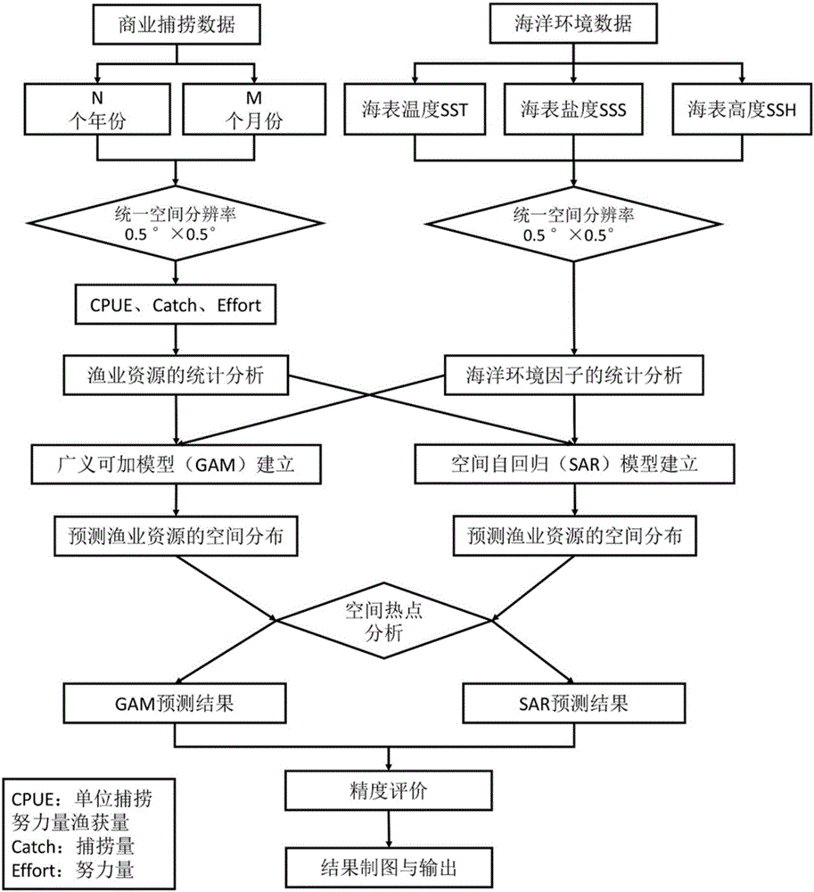
[0051] The following will clearly and completely describe the technical solutions in the embodiments of the present invention with reference to the drawings in the embodiments of the present invention. Obviously, the described embodiments are part of the embodiments of the present invention, not all of them. Based on the embodiments of the present invention, all other embodiments obtained by persons of ordinary skill in the art without making creative efforts shall fall within the protection scope of the present invention.

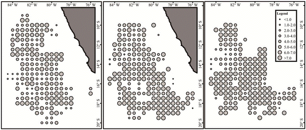
[0052] 1) Based on the fishery data of Peruvian squid from October, November and December of 2009 to 2013, from the recorded fishing data, the date, latitude and longitude, catch and catch amount were obtained, and the squid fish Yield data is converted to catch per unit fishing effort, and the CPUE distribution map is drawn, such as figure 2 ; Access to commercial fishery data and marine environmental data (SST, SSS and SSH);

[0053] 2) Analyze the spati...


PUM


Abstract

The invention relates to a method for identifying Dosidicus gigas spatial distribution and a marine environment influence. The method comprises the following steps: 1) obtaining commercial fishing data of Dosidicus gigas and marine environment remote sensing data, and converting catch into catch per unit effort (CPUE); 2) monthly performing spatial distribution analysis for CPUE drawings of the Dosidicus gigas; 3) drawing a box plot for the marine environment data, and analyzing changes of marine environment factors in various months; 4) according to existing data, performing conjoint analysis for the CPUE, SST, SSS and SSH adopting an SAR model, and obtaining a relationship between the CPUE and the marine environment factors; and 6) predicting spatial distribution of a Dosidicus gigas resource by utilizing an established GAM model and the established SAR model, and evaluating an obtained result by utilizing a precision index. Compared with the prior art, the method has the advantages of significantly improved prediction accuracy and the like.

Description

technical field [0001] The invention relates to a method for identifying the spatial distribution and environmental impact of fishery resources, in particular to a method for identifying the spatial distribution of squid squid and the impact on the marine environment based on spatial autoregressive SAR. Background technique [0002] Pelagic fishery activities are carried out in a certain space-time range, so for the serial correlation problem that is common in time series data, and these data have significant spatial characteristics. The work on fishery resources in our country continues to deepen and gradually mature, and researchers can find relevant data on fishery operations relatively easily. These data are generally combined by temporal data and spatial data. With the improvement of statistical methods of fishery resources in our country, remote sensing and GIS technology have been incorporated into marine fishery, which provides support for the study of spatial distr...

Claims


Application Information

Patent Timeline
IPC IPC(8): G06Q10/04G06Q50/02
CPCG06Q10/04G06Q50/02
Inventor 冯永玖崔丽陈新军
Owner SHANGHAI OCEAN UNIV
Why Eureka
Try Eureka