
Traffic label identification method of vehicle-mounted laser scanning point cloud data

A vehicle-mounted laser scanning and traffic signage technology, applied in character recognition, character and pattern recognition, instruments, etc., to reduce the probability of traffic accidents, assist navigation and decision-making, and enhance the effect of differentiation

Active Publication Date: 2016-11-16
NANJING FORESTRY UNIV
View PDF5 Cites 57 Cited by
  • Summary
  • Abstract
  • Description
  • Claims
  • Application Information

AI Technical Summary

Problems solved by technology

[0009] The present invention proposes a traffic sign recognition method based on vehicle-mounted laser scanning point cloud data. Drawbacks of the signage method

Method used


Image

  • Traffic label identification method of vehicle-mounted laser scanning point cloud data
  • Traffic label identification method of vehicle-mounted laser scanning point cloud data

Examples


Embodiment Construction

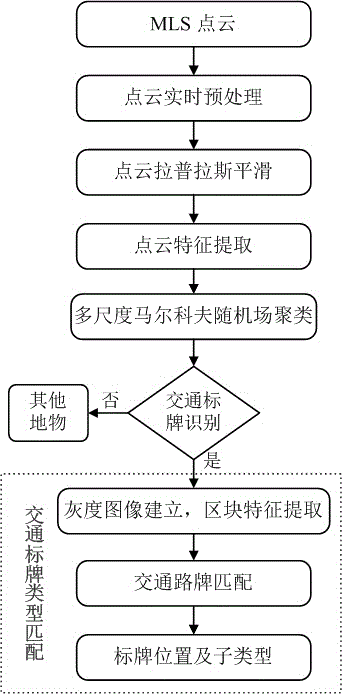
[0023] With reference to the accompanying drawings, the traffic sign recognition method of vehicle-mounted laser scanning point cloud data, the method comprises the following steps:

[0024] (1) Real-time preprocessing of point cloud;

[0025] (2) Acquisition of point cloud structure features;

[0026] (3) Multi-scale Markov random field point cloud clustering;

[0027] (4) Identification of traffic signs.

[0028] The main functions of the real-time preprocessing of the point cloud are: limiting the field of view and reducing the number of point clouds processed in real time; Preprocessing can greatly reduce the scale of processed data so that the system can detect traffic signs online in real time. The specific preprocessing steps are as follows:

[0029] ① Eliminate points outside the field of view: through a simple threshold method, the current vehicle front, left, right, up and down distance thresholds d (100 m) point cloud removal;

[0030] ② Ground point eliminati...


PUM


Abstract

The invention brings forward a traffic label identification method of vehicle-mounted laser scanning point cloud data. The method comprises the following steps: 1, point cloud real-time preprocessing; 2, point cloud structure feature obtaining; 3, multi-scale Markov random field point cloud clustering; and 4, traffic label identification. The method has the following advantages: "surface-shaped", "linear-shaped" and "scattered" features of point clouds are reinforced, differences between points are enhanced, and while under-segmentation is avoided, reasonable segmentation of the scale of a traffic label component can be rapidly realized; classification and identification of a traffic label can be conveniently realized from point cloud data of deficiency of a part of the traffic label, caused by ground object shielding or ground object self-occlusion; the method can effectively satisfy the requirements for rapid extracting, monitoring and identifying city components at present, can be conveniently promoted to the industry of manned or unmanned navigation and barrier avoiding based on computer vision, helps a driver to perform navigation and decision-making under complex road conditions, and effectively reduces the traffic accident probability.

Description

technical field [0001] The invention proposes a traffic sign recognition method based on vehicle-mounted laser scanning point cloud data, which belongs to the field of remote sensing science and technology. Background technique [0002] At the "China Road Traffic Safety Forum" held in Beijing on August 29, 2013, Huang Ming, vice minister of the Ministry of Public Security, pointed out that by the end of 2012, China had 240 million motor vehicles and 200 million motor vehicle drivers. National Highway Network Planning (2013-2030), the total mileage of my country's highways will reach about 5.8 million kilometers by the end of 2030. The increase in vehicles and complex road conditions will lead to an increasing frequency of traffic accidents, which will pose a huge threat to the safety of our citizens' lives and property. It is urgently needed To establish and improve the traffic safety management system, the intelligent transportation system (Intelligent Transportation System, ...

Claims


Application Information

Patent Timeline
Patent Type & Authority Applications(China)
IPC IPC(8): G06K9/00G06K9/62
CPCG06V20/52G06V30/10G06F18/23
Inventor 陈动杜建丽史玉峰郑加柱史晓云杨强王增利
Owner NANJING FORESTRY UNIV
Learn More