Positioning method and system based on deceptive jamming of satellite navigation signals

A satellite navigation signal and deceptive jamming technology, applied in the field of satellite navigation, can solve the problems of difficult to achieve vehicle positioning, large positioning error of inertial navigation, etc.

Inactive Publication Date: 2019-02-12
武汉大地线科技有限公司
View PDF10 Cites 0 Cited by
  • Summary
  • Abstract
  • Description
  • Claims
  • Application Information

AI Technical Summary

Problems solved by technology

[0004] In urban positioning, when the vehicle is driving in a long tunnel or underground passage, because the satellite navigation signal is completely blocked, and the inertial navigation will also occur random walk within a certain period of time, resulting in a large positioning error, so in this It is difficult to achieve the localization of the vehicle

Method used


Image

  • Positioning method and system based on deceptive jamming of satellite navigation signals
  • Positioning method and system based on deceptive jamming of satellite navigation signals
  • Positioning method and system based on deceptive jamming of satellite navigation signals

Examples


Embodiment Construction

[0053] The specific implementation method and the accompanying drawings of the description will be further described in detail below.

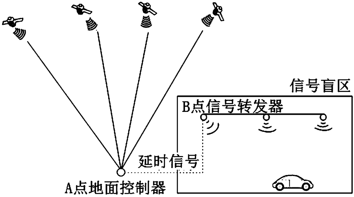
[0054] refer to figure 1 , is the application scene diagram of the positioning method based on the forwarding deception jamming technology of the present invention, including a ground controller, several signal transponders, and a user receiver installed on a vehicle driving in a signal blind zone. The ground controller receives the satellite navigation signal, and modulates the time delay of the satellite navigation signal through the numerical control delay technology to obtain the delayed signal, and transmits the delayed signal to each signal transponder, and the signal transponder transmits the delayed signal in mountain tunnels, underground passages, etc. The signal is broadcast in the signal blind area where the signal is easily blocked, and the user receiver in the effective interference area receives the broadcasted delayed signal and...


PUM


Abstract

The invention discloses a positioning method and system based on satellite-navigation-signal deception jamming. Time delay of received satellite navigation signals is modulated with the transmitting-type deception jamming technology, satellite navigation signals after being time delay are broadcasted in a signal dead zone, and moving carriers driven in the signal dead zone are positioned. Meanwhile, according to the positioning method and system, satellite navigation signals are autonomously generated with the autonomous deception jamming technology, the autonomously-generated satellite navigation signals are sent in the signal dead zone, and finally, the moving carriers driven in the signal dead zone are positioned. By means of the positioning method and system, the problem that the moving carriers in the signal dead zone cannot be positioned is solved, and the accurate positioning result can also be obtained in the signal dead zone.

Description

technical field [0001] The invention belongs to the technical field of satellite navigation, in particular to a method and a system for realizing positioning based on the technical principle of deceptive interference of satellite navigation signals when satellite navigation signals are blocked. Background technique [0002] The GNSS system adopts the principle of three-sphere positioning. After the GNSS signal propagation time is obtained through time difference measurement, the distance between the satellite and the user can be calculated. As long as the coordinates of the satellite are obtained, the coordinates of the positioning point can be calculated through simultaneous equations. In fact, there is always a clock difference between the receiver and the GNSS standard clock, so the pseudo-ranges of at least four stars are needed in the actual positioning, and the timing error is calculated. It can be seen from the above that as long as the receiver can obtain measurement...

Claims


Application Information

Patent Timeline
Patent Type & Authority Patents(China)
IPC IPC(8): G01S19/42G01S19/48
CPCG01S19/42G01S19/48
Inventor 张同
Owner 武汉大地线科技有限公司
Why Eureka
Try Eureka