Sea level rise-based land risk assessment method and device

A risk assessment and sea level technology, applied in data processing applications, instruments, calculations, etc., can solve problems such as low practicability and difficult to deal with coastal city development planning and engineering design

Inactive Publication Date: 2017-05-24
NAT MARINE DATA & INFORMATION SERVICE
View PDF3 Cites 0 Cited by
  • Summary
  • Abstract
  • Description
  • Claims
  • Application Information

AI Technical Summary

Problems solved by technology

[0005] In view of this, the purpose of the present invention is to provide a land risk assessment method and device based on sea level rise to solve the problem tha...

Method used


Image

  • Sea level rise-based land risk assessment method and device
  • Sea level rise-based land risk assessment method and device
  • Sea level rise-based land risk assessment method and device

Examples


Embodiment 1

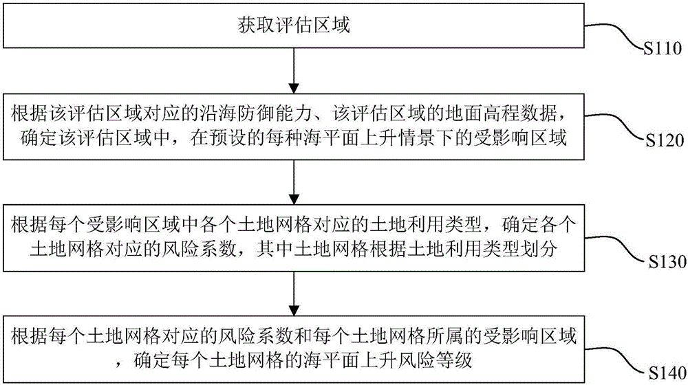
[0030] figure 1 The first schematic flow chart of the land risk assessment method based on sea level rise provided by the first embodiment of the present invention, such as figure 1 As shown, the method includes the following steps:

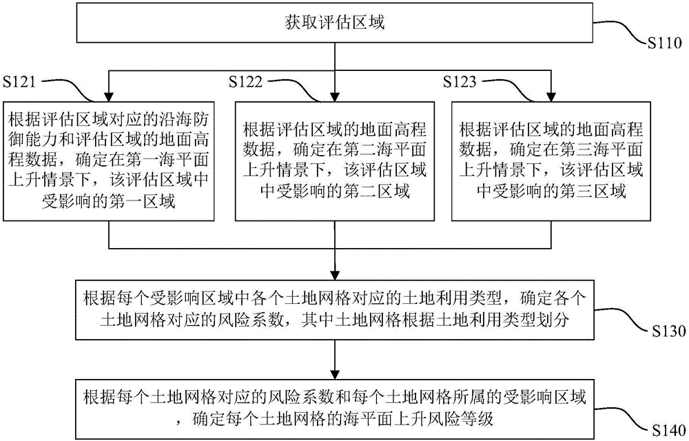
[0031] Step S110, obtaining an evaluation area.

[0032] Obtain the assessment area that requires risk assessment, and the assessment area is generally a coastal area that is vulnerable to sea level rise disasters.

[0033] Step S120, according to the coastal defense capability corresponding to the assessment area and the ground elevation data of the assessment area, determine the affected area in each preset sea level rise scenario in the assessment area.

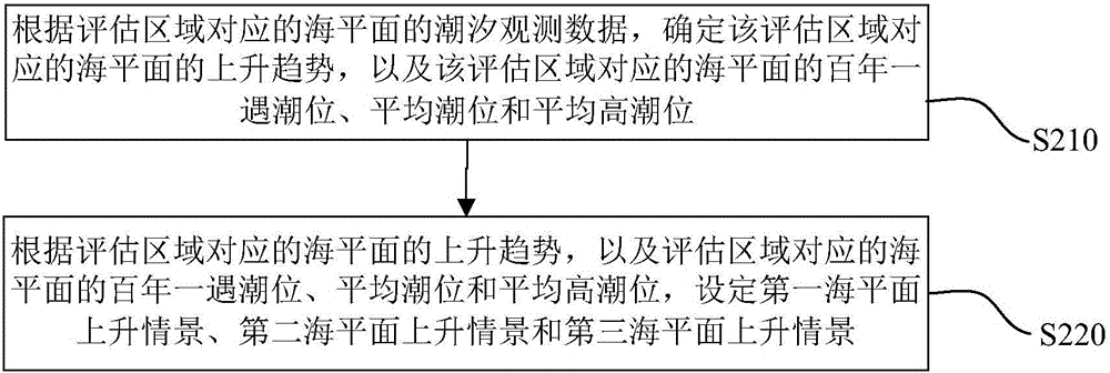
[0034] Considering that under different sea level rise scenarios, the affected areas and degrees in the assessment area are not the same, the method provided by the embodiment of the present invention also includes: setting a variety of sea level rise scenarios, for example, according to th...

Embodiment 2

[0071] Figure 4 A schematic diagram of the module composition of the land risk assessment device based on sea level rise provided by the second embodiment of the present invention, such as Figure 4 As shown, the land risk assessment device based on sea level rise provided by the embodiment of the present invention includes: an assessment area acquisition module 10, which is used to acquire the assessment area; an affected area determination module 20, which is used to determine the coastal defense capability, The ground elevation data of the evaluation area is used to determine the affected area under each preset sea level rise scenario in the evaluation area; the risk factor determination module 30 is used to determine the corresponding land grid in each affected area The land use type is used to determine the risk coefficient corresponding to each land grid, wherein the land grid is divided according to the land use type; the risk level determination module 40 is used to d...


PUM


Abstract

The invention provides a sea level rise-based land risk assessment method and a device and relates to the technical field of the marine environment forecasting technology. The sea level rise-based land risk assessment method comprises the steps of obtaining an evaluation region; according to the coastal defense capability corresponding to the evaluation region and the ground elevation data of the evaluation region, determining the involved area in the evaluation region in each preset sea level rising situation; according to a land-use type corresponding to each land grid in the involved area, determining a corresponding risk coefficient for each land grid; according to the risk coefficient corresponding to each land grid and the involved area of the land grid, determining the sea level rising risk level for each land grid. According to the technical scheme of the sea level rise-based land risk assessment method and the device, the technical problems in the prior art that, existing assessment methods are not high in practicality and difficult to meet the requirements of development programs and engineering designs in coastal cities, can be solved.

Description

technical field [0001] The invention relates to the technical field of marine environment forecasting, in particular to a land risk assessment method and device based on sea level rise. Background technique [0002] Sea level rise is a slow-onset disaster and has become one of the major threats to human beings. The continuous rise of sea level will lead to land inundation in coastal areas, aggravate storm surge and flood disasters, and aggravate soil salinization, thus threatening the safety of buildings and ecological resources in coastal areas, and directly affecting social and economic development and people's production and life. [0003] At present, relevant sea level rise risk assessment methods are mainly combined with socio-economic data vulnerability assessment methods. This method divides assessment units according to the administrative divisions of the assessment area, constructs a sea level rise vulnerability assessment system, and builds a sea level rise vulnera...

Claims


Application Information

Patent Timeline
IPC IPC(8): G06Q10/06
CPCG06Q10/0635
Inventor 李响高志刚高通张建立王慧刘克修
Owner NAT MARINE DATA & INFORMATION SERVICE
Why Eureka
Try Eureka