Geographic Ontology Modeling and Semantic Reasoning Based on Object-Oriented Image Features

A geographic ontology and object-oriented technology, applied in 3D modeling, image data processing, image analysis, etc., can solve the problems of insufficient multi-scale expression, inability to interoperate with concept-based reasoning theory and semantics, and reduce heavy investment pressure. The effect of eliminating the island effect

Active Publication Date: 2020-04-21
浙江时空智子大数据有限公司
View PDF3 Cites 0 Cited by
  • Summary
  • Abstract
  • Description
  • Claims
  • Application Information

AI Technical Summary

Problems solved by technology

[0007] The technical problem to be solved by the present invention is to provide a geographic ontology modeling and semantic reasoning method based on object-oriented image features in view of the lack of multi-scale expression in the prior art and the inability to perform semantic interoperability through concept-based reasoning theory

Method used


Image

  • Geographic Ontology Modeling and Semantic Reasoning Based on Object-Oriented Image Features
  • Geographic Ontology Modeling and Semantic Reasoning Based on Object-Oriented Image Features
  • Geographic Ontology Modeling and Semantic Reasoning Based on Object-Oriented Image Features

Examples


Embodiment Construction

[0043] In order to make the object, technical solution and advantages of the present invention clearer, the present invention will be further described in detail below in conjunction with the accompanying drawings and embodiments. It should be understood that the specific embodiments described here are only used to explain the present invention, not to limit the present invention.

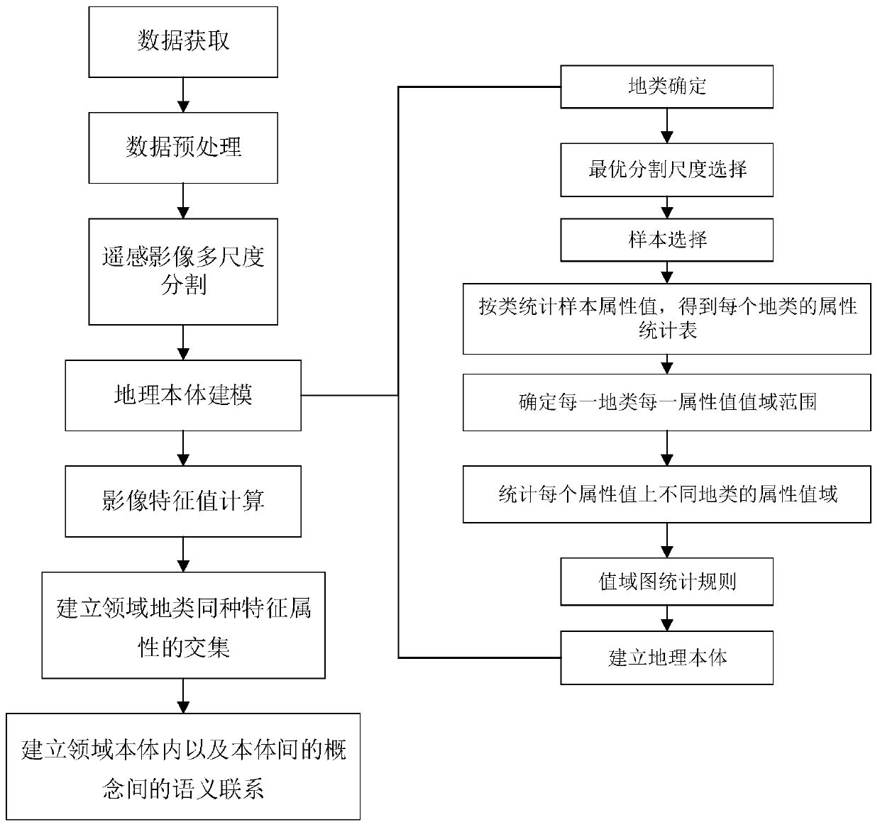
[0044] Such as figure 1 As shown, the geographic ontology modeling and semantic reasoning method based on object-oriented image features in the embodiment of the present invention includes the following steps:

[0045] S1. Acquire high-resolution remote sensing images of the research area, perform preprocessing and multi-scale segmentation on the high-resolution remote sensing images, and establish image object hierarchy; preprocessing methods include: geometric correction, atmospheric correction, cropping and stitching, etc.

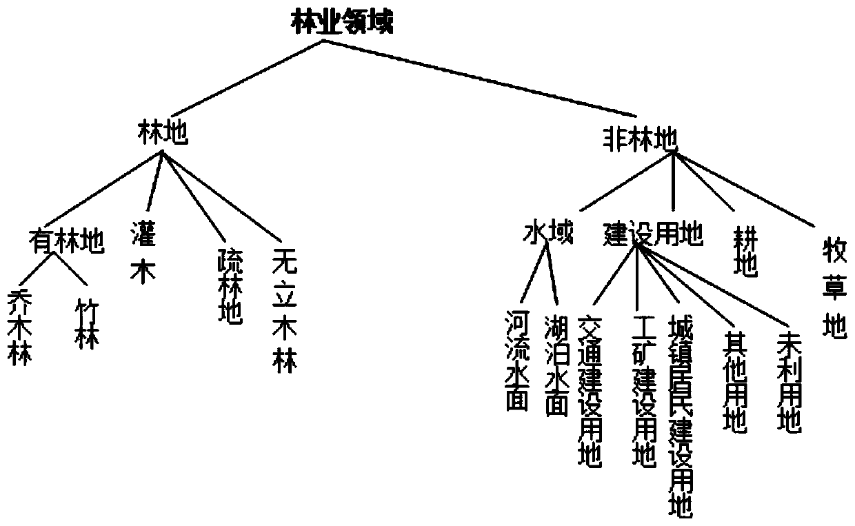
[0046] S2. Carry out domain division according to the hierarchical str...


PUM


Abstract

The invention discloses an object-oriented image characteristic-based geographic ontology modeling and semantic reasoning method. The method comprises the following steps of: S1, carrying out preprocessing and multi-scale segmentation on a high-resolution remote sensing image of a researched district so as to obtain an object hierarchical structure; S2, carrying out territory division and carrying out land type division on each territory; carrying out geographic ontology modeling on different land types of each territory according to remote sensing characteristic values of the high-resolution remote sensing image; S3, for geographic ontologies of different territories, calculating a value domain of each remote sensing characteristic value of each land type, and calculating intersected sets and union sets of value domains of different land types; and S4, establishing semantic association of the land types in the territories and the land types between different territories. According to the method, the semantic integration and interoperation between different geographic ontology systems can be realized, so as to push the process of space information socialization, decrease the heavy investment pressure caused by repeated acquisition of basic space data to the greatest extent, and eliminate the islanding effect of space information systems in different territories.

Description

technical field [0001] The invention relates to the field of spatial information sharing, in particular to a geographic ontology modeling and semantic reasoning method based on object-oriented image features. Background technique [0002] The spatial information system has rapidly developed from a stand-alone version to a spatial information grid. With the improvement of spatial information integration and the increasing demand for spatial information sharing and interoperability in different fields, several problems need to be solved urgently. Among them, the most difficult problem is the inconsistency of spatial information semantic expression, and the core problem of spatial information semantic grid is how to solve the semantic reasoning problem between geographic ontology systems in different fields. [0003] At present, in the field of spatial information, geographic ontology modeling is often discussed with the help of research methods in the field of information syst...

Claims


Application Information

Patent Timeline
Patent Type & Authority Patents(China)
IPC IPC(8): G06T17/05G06T7/10
CPCG06T17/05G06T2207/10032
Inventor 崔巍周琪郑振东
Owner 浙江时空智子大数据有限公司
Why Eureka
Try Eureka