Whole space information expression method and whole space information system

An information expression, full-space technology, applied in the field of spatial expression of surveying and mapping geographic information, can solve the problems of difficult data fusion, lack of geographic reference system, inconsistency of multi-source spatial data, etc., to achieve the effect of increasing the time attribute

Active Publication Date: 2017-06-13
CHINESE ACAD OF SURVEYING & MAPPING
View PDF3 Cites 19 Cited by
  • Summary
  • Abstract
  • Description
  • Claims
  • Application Information

AI Technical Summary

Problems solved by technology

Second, from the perspective of space, the accuracy of spatial data is getting higher and higher, which greatly improves the accuracy of urban management. The application of big data has improved the efficiency and accuracy of data utilization. etc.) have established un

Method used


Image

  • Whole space information expression method and whole space information system
  • Whole space information expression method and whole space information system
  • Whole space information expression method and whole space information system

Examples


Embodiment 1

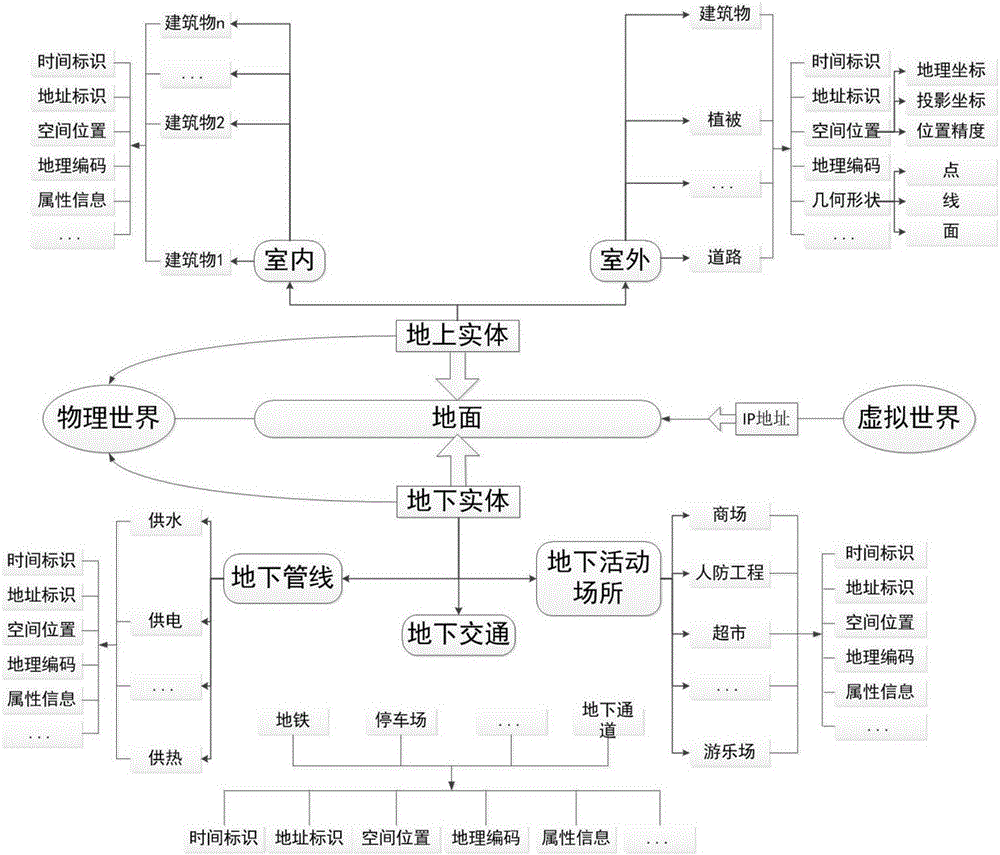
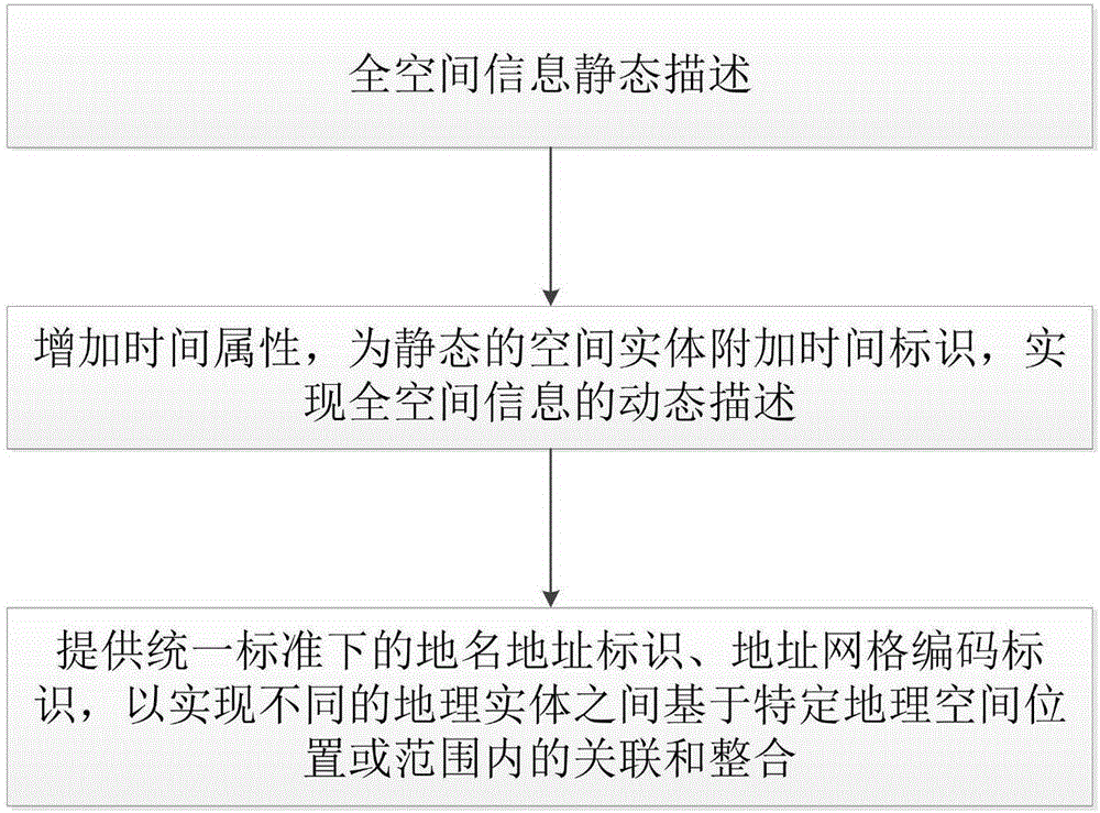
[0034] Such as figure 1 As shown, in the embodiment of the present invention, a method for expressing full spatial information includes the following content:

[0035] Full space information includes the following two meanings: (1) "Full space" refers to the three-dimensional space based on the earth's surface, including traditional open space, such as the space of cultivated land, rivers, vegetation, buildings and other ground entities, as well as The space of underground entities such as underground transportation, underground pipelines, and underground civil air defense that meets the needs of urban development; includes both outdoor space and indoor space, and realizes the integration of indoor and outdoor, above-ground and underground; (2) "full information" includes both spatial entities The three-dimensional information of space, time, and attributes, as well as other thematic information fused through place names and addresses with location as a link, mainly expressed ...


PUM


Abstract

The invention discloses a whole space information expression method and a whole space information system. The method includes following steps: statically describing whole space information which includes position coordinates (x, y, z) and natural attributed information of a space entity in physical world and network virtual world; adding time attribute, and adding a time identity for the space entity in a static state to realize dynamic description of the whole space information; providing place name address identity and address grid coding identity under uniform time-space standards to realize correlation and integration of different space entities based on geographic space position or range. The system comprises a space entity description module, a time identity module and a place name address description module. The whole space information expression method is used for realizing dynamic description and combining communication of all space entities having position information in the virtual world and realizing whole space information expression of geographic position, natural attribute and time-space attribute of the space entities and thematic data under the uniform time-space standards.

Description

technical field [0001] The invention relates to the technical field of spatial expression of surveying and mapping geographic information, in particular to a full-spatial information expression method and a full-spatial information system. Background technique [0002] In recent years, with the development and popularization of information and communication technology, many achievements have been made in the construction of digital cities in China, and the construction of smart cities is the current upsurge. The development and construction of smart cities has brought unprecedented opportunities and challenges to my country's urban planning and management. In the field of surveying and mapping geographic information, the basic space-time concept of traditional urban planning and management objects has developed to a new stage. [0003] There are two challenges in the new stage: First, in terms of time, the current time interval is greatly shortened, and the demand for real-t...

Claims


Application Information

Patent Timeline
IPC IPC(8): G06F17/30G06T19/00
CPCG06F16/29G06T19/006
Inventor 李成名印洁刘晓丽武鹏达马照亭吴政刘坡刘振东路文娟
Owner CHINESE ACAD OF SURVEYING & MAPPING
Why Eureka
Try Eureka