Device for synchronously acquiring external data of aerial surveying camera

A technology of external orientation data and aerial survey camera, which is applied in the direction of surveying device, surveying and navigation, radio wave measurement system, etc. It can solve the problems of image processing error and inaccurate external orientation data, so as to avoid interference, improve aerial survey accuracy, The effect of ensuring flight quality

Inactive Publication Date: 2017-06-20
广西翼界科技有限公司
View PDF5 Cites 0 Cited by
  • Summary
  • Abstract
  • Description
  • Claims
  • Application Information

AI Technical Summary

Problems solved by technology

However, due to the inconsistency between the installation position and angle of the sensor and the camera, the external orientation data given by the flight controller when taking pictures of the camera is not very accurate, resulting in post-image processing errors

Method used


Image

  • Device for synchronously acquiring external data of aerial surveying camera
  • Device for synchronously acquiring external data of aerial surveying camera

Examples


Embodiment Construction

[0014] Below in conjunction with accompanying drawing and specific examples the present invention will be further described:

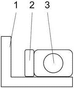
[0015] as attached figure 1 As shown in , the aerial survey camera external orientation data synchronous acquisition device (2) is fixedly connected with the aerial survey camera (3) on the gimbal (1).

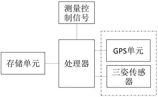
[0016] as attached figure 2 As shown in , the device (2) includes a processor, and the front end of the processor is connected to receive the measurement control signal input consistent with the aerial survey camera; and the processor is also used to identify the GPS unit of the aerial survey camera position coordinates, and to obtain the aerial survey camera pitch , three attitude sensors for rolling and heading angles, and a storage unit for storing data.

[0017] The three-position sensor and the aerial survey camera are placed horizontally, in the same direction as the CCD photosensitive surface in the aerial survey camera. When the aerial surv...


PUM


Abstract

The invention discloses a device for synchronously acquiring external data of an aerial surveying camera and belongs to the technical field of aerial surveying equipment. The device comprises a processor which is connected with and is used for receiving a measuring control signal input; the processor is respectively connected with a sensor unit and a storage unit; the sensor unit is used for recognizing the position coordinate and posture of the aerial surveying camera; the storage unit is used for storing data; the device is wholly fixed with the aerial surveying camera or the sensor unit is fixedly arranged in the aerial surveying camera. The sensor unit and the aerial surveying camera keep the same physical state, so that the device can practically acquire the external data of the camera and the aerial surveying precision is increased.

Description

technical field [0001] The invention discloses a device for synchronously acquiring external orientation data of an aerial survey camera, which belongs to the technical field of aerial survey equipment. Background technique [0002] The aerial survey technology that uses unmanned aerial vehicles to carry cameras on the flying platform for remote measurement continues to develop. Its outstanding advantages are low risk, high efficiency, flexible maneuvering, no high-intensity field operations, simple operation and maintenance, and wide application. [0003] To obtain high-precision aerial survey results, it is necessary to simultaneously obtain various external orientation data during aerial survey imaging, including three-axis attitude, position coordinates, etc., to provide basic data for later image correction, fusion, and splicing. In the prior art, the outer orientation data is indirectly provided by the airborne flight control system. However, due to the inconsistency ...

Claims


Application Information

Patent Timeline
Patent Type & Authority Applications(China)
IPC IPC(8): G01C11/00G01S19/42
CPCG01C11/00G01S19/42
Inventor 吴东乔尹宝新
Owner 广西翼界科技有限公司
Why Eureka
Try Eureka