Combined navigation method for GNSS+INS+odo
A combined navigation and module technology, applied in the field of combined navigation, can solve problems such as GNSS signals are susceptible to interference, INS device prices are high, and calculations are affected by gravity fields, etc., to achieve easy vehicle-mounted industrialization development, excellent effects, and improved stability sexual effect
- Summary
- Abstract
- Description
- Claims
- Application Information
AI Technical Summary
Problems solved by technology
Method used
Image

Examples
Embodiment Construction
[0032] The solution of the present invention will be described in detail below in combination with the preferred embodiments thereof.
[0033] The present invention proposes a combined navigation system of GNSS+INS+odo, which uses the positioning and speed information output by GNSS, the precision factor of GNSS positioning and speed information, and the gyroscope and accelerometer information output by INS devices during fusion calculation. , and the speed information output by the odometer to complete continuous high-precision positioning speed and attitude information.
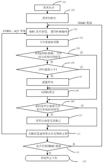
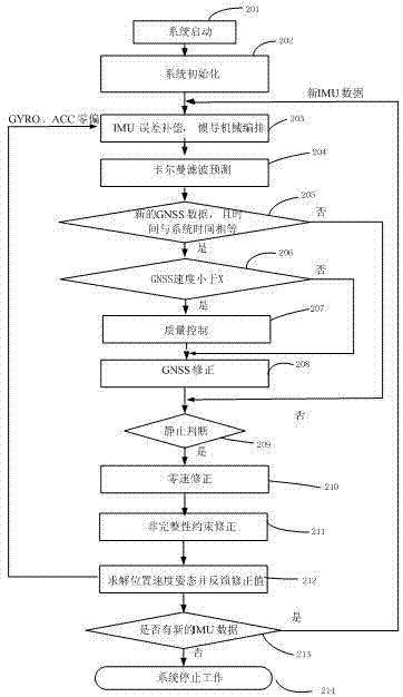
[0034] Its specific process is as figure 1 Shown:
[0035] 1) System start 101;
[0036] 2) The system is initialized 102, including noise matrix, weight matrix, state vector, initial state of navigation, etc.;
[0037] 3) Perform error compensation on the IMU data output by the INS device, and perform INS mechanical arrangement 103;
[0038] 4) Calculate the state transition matrix and perform Kalman f...
PUM
 Abstract
Description
Claims
Application Information
 - R&D Engineer
- R&D Manager
- IP Professional
- Industry Leading Data Capabilities
- Powerful AI technology
- Patent DNA Extraction
Browse by: Latest US Patents, China's latest patents, Technical Efficacy Thesaurus, Application Domain, Technology Topic.
© 2024 PatSnap. All rights reserved.Legal|Privacy policy|Modern Slavery Act Transparency Statement|Sitemap