Seismic data-based buried hill oil and gas field underground geological map compiling method

A technology for seismic data and geological maps, used in seismology, seismic signal processing, geophysical measurement, etc.

Active Publication Date: 2017-08-18
CHINA UNIV OF PETROLEUM (EAST CHINA)
View PDF9 Cites 10 Cited by
  • Summary
  • Abstract
  • Description
  • Claims
  • Application Information

AI Technical Summary

Problems solved by technology

The existing topographic and geological map compilation methods cannot be directly copied for the compilation of subsurface geological maps for buried hill oil and gas fields

Method used


Image

  • Seismic data-based buried hill oil and gas field underground geological map compiling method
  • Seismic data-based buried hill oil and gas field underground geological map compiling method
  • Seismic data-based buried hill oil and gas field underground geological map compiling method

Examples


Embodiment Construction

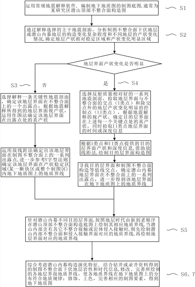
[0036] combined with Figure 1-8 , the present invention is further described: a kind of utilization deep seismic reflection data, confirms the preparation method of underground geological map of buried hill oil and gas field, and specific implementation scheme comprises the following steps ( figure 1 ):

[0037] (1) Use conventional seismic interpretation software such as Discover, Landmark, and Geoframe to draw the corresponding unconformity surface T at the top of the buried hill through seismic section interpretation 0 Or depth structure map, the base map for compiling the subsurface geological map of buried hill oil and gas fields.

[0038] (2) According to the deep seismic reflection data, analyze the complexity of structural changes in the inner buried hill and the occurrence changes of different strata, and determine the relatively stable area and the obvious change area of ​​the stratum interface. When the mapping area is large and covered by a large When the baseme...


PUM


Abstract

The invention discloses a seismic reflection data-based buried hill oil and gas field underground geological map compiling method. The method is characterized by comprising the following steps: S1, a base drawing map of the buried hill oil and gas field underground geological map is compiled; S2, a stratum attitude stable area and an attitude change obvious area in the drawing area are determined; S3, an inner buried hill stratum attitude relative stable area and a stratum boundary on the underground geological map are compiled; S4, a stratum boundary in the inner buried hill stratum attitude change obvious area is compiled; S5, according to a sequence of stratum ages from new to old, geological boundaries for different target stratum interfaces of the inner buried hill are drawn respectively; and S6-7, each geological boundary is changed and perfected to obtain the underground geological map. On one hand, the workload of seismic profile interpretation is greatly reduced, the drawing time is saved, the drawing efficiency is improved, and on the other hand, the restriction of the overall poor quality of deep seismic reflection data to compilation of the underground (ancient) geological map can be overcome effectively.

Description

technical field [0001] The invention relates to the technical field of seismic data interpretation, in particular to a method for systematically proposing underground geological maps of buried hill oil and gas fields based on deep seismic reflection data combined with actual underground geological characteristics. Background technique [0002] With the continuous deepening of exploration and development of shallow oil and gas reservoirs in eastern my country, shallow oil and gas exploration is becoming more and more difficult. In recent years, more and more attention has been paid to deep ancient buried hill oil and gas reservoirs. As a kind of paleogeomorphic uplift, the buried hill is formed by the long-term weathering and denudation of the stratum after the crustal movement, and then subsides again and is covered by the overlying strata. Therefore, the buried hill is bounded by the unconformity surface and the overlying strata. Specifically, in the Bohai Bay Basin in east...

Claims


Application Information

Patent Timeline
Patent Type & Authority Applications(China)
IPC IPC(8): G01V1/30
CPCG01V1/306G01V2210/624
Inventor 陆诗阔管国健李冬冬刘会见贾祥明宋星琨
Owner CHINA UNIV OF PETROLEUM (EAST CHINA)
Why Eureka
Try Eureka