On-map distance rapid-interpretation method and map for achieving method

A map and distance technology, applied in the directions of maps/plans/charts, educational tools, instruments, etc., can solve the problems of difficulty in implementation, different map scales, complicated conversion process, etc., to achieve accurate results and eliminate reading and calculation errors.

Active Publication Date: 2017-08-18
中国人民解放军69080部队
View PDF6 Cites 0 Cited by
  • Summary
  • Abstract
  • Description
  • Claims
  • Application Information

AI Technical Summary

Problems solved by technology

Due to the large denominator of the scale and the different map scales, the conversion process is cumbersome, and non-professionals are especially prone to errors. Sometimes it is difficult to implement in the field and at night due to the lack of corresponding tools.

Method used


Image

  • On-map distance rapid-interpretation method and map for achieving method

Examples


example 1

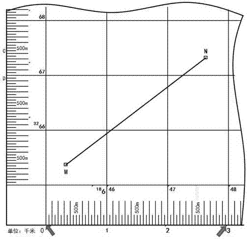
[0024] As shown in the attached figure, it is intended to interpret the horizontal distance between points M and N.

[0025] The first way: with the way before the present invention. The method of measuring distance generally includes three steps: point selection, measurement, and conversion. The first step is to select two points M and N. As a rule of thumb, connect M and N with a straight line; Often can not find, especially night work is more difficult. In this stage, it is necessary to try to avoid the situation that the map is damaged or scrapped due to the color of the delineated target point being too dark or the connection line being too wide or too dark. The second step is to measure. Measure the length between two points. After actual measurement on the 1:5 map, the length of the MN line segment is 59 mm. The third step is conversion. First of all, the unit of length must be meter, that is, the length on the map between MN is 0.059 meters. Substitute the follow...


PUM


Abstract

The invention relates to an on-map distance rapid-interpretation method and a map for achieving the method. The method comprises the following steps: a length between two points is clamped by a compass, and then a tension degree of the compass is obtained; and a distance is directly read by utilizing a linear scale on the map. The total length of the linear scale of the map is as close to a length of external graph profile of the map as possible, and parts between marked kilometer numbers are scored by meters and are marked. A people's bias against the linear scale is overcome, the problem desiring to be solve for a long term is solved, and an unexpected result is got; a length on the map does not need to be accurately read out but is accurately clamped in the measurement process; measurement is changed to clamp the tension degree of the compass, so corresponding measurement tools such as a straight ruler, a scale and a command ruler are omitted; an equation does not need to be set up and solved, so paper, a pen or a calculator are omitted; a result is accurate, so reading and calculation errors are eliminated; and the method is convenient and efficient, and is convenient to use in the wild and at night.

Description

technical field [0001] The invention relates to a method for quickly interpreting distance on a map and a map for realizing the method, including point selection, measurement and conversion. Background technique [0002] With the wide application of vehicles, airplanes and other large and rapid means of transportation, people's demand for maps continues to expand. The existing method for measuring distance generally includes the following steps: selecting a point, measuring, and converting. Select points and sometimes connect lines; measure is to read the length between two points; conversion is to solve according to the scale equation, paying special attention to the unity of units. Due to the large denominator of the scale and the different map scales, the conversion process is cumbersome, and non-professionals are especially prone to make mistakes. Sometimes it is difficult to implement in the field and at night due to the lack of corresponding tools. Contents of the...

Claims


Application Information

Patent Timeline
Patent Type & Authority Applications(China)
IPC IPC(8): G09B29/10G09B29/00
CPCG09B29/00G09B29/10
Inventor 徐云林文禄朱剑徐卫东
Owner 中国人民解放军69080部队
Why Eureka
Try Eureka