Geographic information data processing method and device

A technology for geographic information data and processing methods, which is applied in the field of geographic information data processing methods and devices, and can solve problems such as inability to efficiently and accurately obtain geographic information data, result data, etc.

Inactive Publication Date: 2017-09-12
北京旋极伏羲大数据技术有限公司
View PDF3 Cites 21 Cited by
  • Summary
  • Abstract
  • Description
  • Claims
  • Application Information

AI Technical Summary

Problems solved by technology

[0004] In view of this, one of the technical problems solved by the embodiments of the present invention is to provide a geographic information data processing method and device to solve the problem of inability

Method used


Image

  • Geographic information data processing method and device
  • Geographic information data processing method and device

Examples


Example Embodiment

[0011] Of course, implementing any technical solution of the embodiments of the present invention does not necessarily need to achieve all the above advantages at the same time.

[0012] In order to enable those skilled in the art to better understand the technical solutions in the embodiments of the present invention, the following will clearly and completely describe the technical solutions in the embodiments of the present invention in conjunction with the accompanying drawings in the embodiments of the present invention. Obviously, the described The embodiments are only some of the embodiments of the present invention, but not all of them. All other embodiments obtained by persons of ordinary skill in the art based on the embodiments in the embodiments of the present invention shall fall within the protection scope of the embodiments of the present invention.

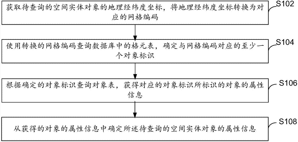
[0013] refer to figure 1 , shows a flowchart of steps of a geographic information data processing method accordi...


PUM


Abstract

The embodiment of the invention provides a geographic information data processing method and device. The geographic information data processing method comprises the following steps: acquiring geographic latitude and longitude coordinates of a spatial entity object to be inquired, and converting the geographic latitude and longitude coordinates into corresponding grid codes; inquiring grid elements in a database by use of the converted grid codes, and determining at least one object identifier corresponding to the grid codes, wherein corresponding relationships between the grid codes and the corresponding object identifiers are stored in the grid elements; inquiring an object table according to the determined object identifiers to obtain attribute information of objects identified by the corresponding object identifiers, wherein the object identifiers and the attribute information of the corresponding objects are stored in the object table; and determining attribute information of the spatial entity object to be inquired from the obtained attribute information of the objects. According to the embodiment of the invention, spatial inquiry conditions are converted into numerical matching of the grid codes, so that the effect of efficiently and accurately acquiring result data of geographic information data operation is achieved.

Description

technical field [0001] Embodiments of the present invention relate to the technical field of geographic information, and in particular, to a geographic information data processing method and device. Background technique [0002] GIS (Geographic Information System, geographic information system) technology is a technology that combines geography, cartography, remote sensing and computer science, and is widely used in different fields, such as navigation, space research and so on. [0003] In GIS, the geographic latitude and longitude coordinate layer is generally used as the basis of geographic information data organization, and based on this, corresponding operations such as query and statistics are performed based on the latitude and longitude coordinates of physical space objects. However, the longitude and latitude coordinates cannot uniquely identify the location of the entity space object, and the assignment of the identification ID of the space entity object is random....

Claims


Application Information

Patent Timeline
IPC IPC(8): G06F17/30
CPCG06F16/29
Inventor 李长王春泉刘隆关亚娟许蒙党荣凯
Owner 北京旋极伏羲大数据技术有限公司
Why Eureka
Try Eureka