Three-dimensional coordinate transformation method and device based on coordinate projection

A technology of three-dimensional coordinates and conversion methods, which is applied in the directions of measuring devices, instruments, surveying and navigation, etc., can solve the problems of limited scope of application and low conversion precision, and achieve the effects of improving computing speed, simple processing methods, and ensuring accuracy

Active Publication Date: 2017-11-24
CENT SOUTH UNIV
View PDF3 Cites 20 Cited by
  • Summary
  • Abstract
  • Description
  • Claims
  • Application Information

AI Technical Summary

Problems solved by technology

[0004] The present invention provides a three-dimensional coordinate conversion method and device based on coordinate projection for solving the problems existing in the prior art such as the limited scope of application of the coordinate rotation method or low conversion precision.

Method used


Image

  • Three-dimensional coordinate transformation method and device based on coordinate projection
  • Three-dimensional coordinate transformation method and device based on coordinate projection
  • Three-dimensional coordinate transformation method and device based on coordinate projection

Examples


Embodiment 1

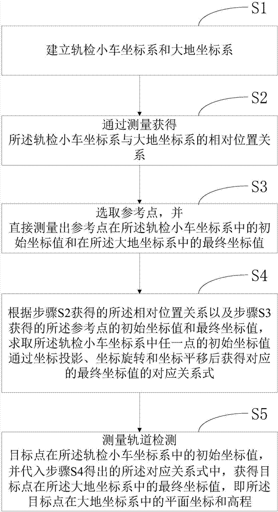
[0057] figure 1 It shows a three-dimensional coordinate conversion method based on coordinate projection provided by this embodiment, including:

[0058] Step S1: Establish the track inspection trolley coordinate system and the earth coordinate system.

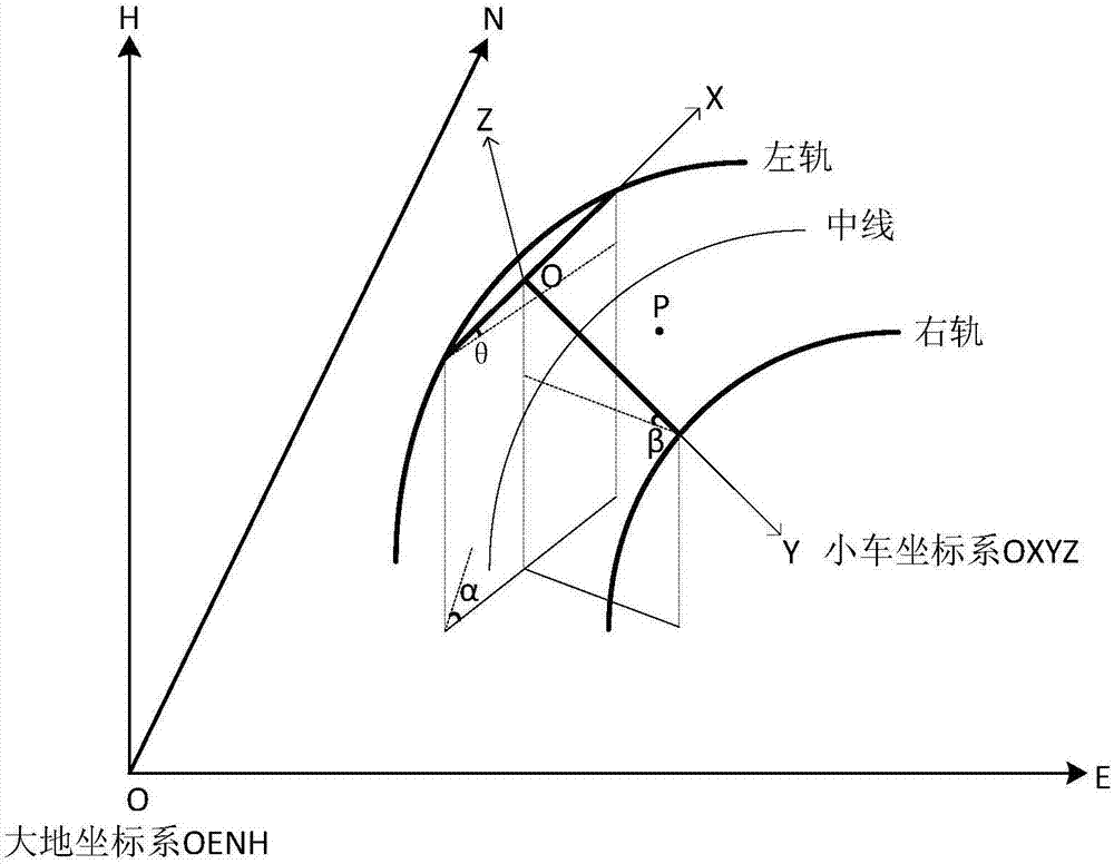
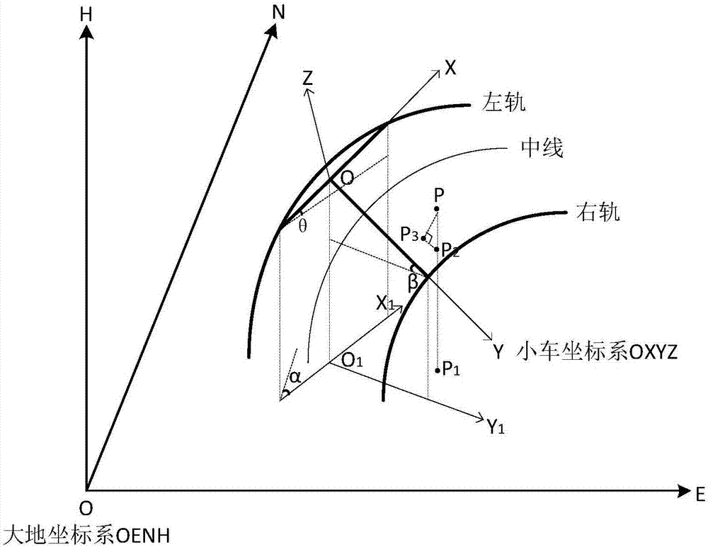
[0059] Such as figure 2 As shown, the track inspection car coordinate system OXYZ and the earth coordinate system OENH are established. The specific establishment method of the coordinate system OXYZ of the track inspection trolley is: take the intersection point of the double-wheel beam and the single-wheel beam of the track inspection trolley as the coordinate origin O, take the straight line where the double-wheel beam is located as the X-axis, and take the straight line where the single-wheel beam is located as the Y-axis , establish the track inspection trolley coordinate system OXYZ with the Z axis perpendicular to the XOY plane, wherein the direction of the track mileage increase is the positive axis direction of the...

Embodiment 2

[0110] Such as Image 6 As shown, the present invention also provides a three-dimensional coordinate conversion device based on coordinate projection, including: a coordinate system establishment module 10, a relative position acquisition module 20, a reference point acquisition module 30, a correspondence derivation module 40 and an application module 50, wherein , the corresponding relationship derivation module 40 further includes a plane coordinate relationship submodule 41 , an elevation coordinate relationship submodule 42 and a merging submodule 43 .

[0111] The coordinate system establishing module 10 is used to establish the track inspection trolley coordinate system and the earth coordinate system.

[0112] Specifically, the coordinate system establishing module 10 takes the intersection point of the double-wheel beam and the single-wheel beam of the track inspection trolley as the coordinate origin O, the straight line where the double-wheel beam is located as the ...


PUM


Abstract

The invention provides a three-dimensional coordinate transformation method and device based on coordinate projection. The method comprises the following steps: establishing a track-detection car coordinate system and a geodetic coordinate system; acquiring relative position relationship between the track-detection car coordinate system and the geodetic coordinate system by measurement; selecting reference points and directly measuring out initial coordinate values of the reference points in the track-detection car coordinate system and final coordinate values of the reference points in the geodetic coordinate system; according to the relative position relationship and the initial coordinate values and the final coordinate values of the reference points, solving a corresponding relation formula which adopts coordinate projection, coordinate rotation and coordinate translation for the initial coordinate value of any point in the track-detection car coordinate system to obtain the finial coordinate value; and measuring initial coordinate values of track-detection target points in the track-detection car coordinate system, and substituting into the corresponding relation formula obtained in the former step to acquire finial coordinate values of the track-detection target points in the geodetic coordinate system. The three-dimensional coordinate transformation method and device provided by the invention have the advantages that by dimension-reducing processing, the operation process is simplified and the computational accuracy is increased.

Description

technical field [0001] The invention relates to the technical field of railway track plane coordinates and elevation measurement, in particular to a three-dimensional coordinate conversion method and device based on coordinate projection. Background technique [0002] In the static geometric state detection of railway tracks, it is necessary to calculate the external geometric state parameters of the track by measuring the plane coordinates and elevation of the track, and then reflect the smoothness of the track. However, in the actual track state monitoring, the plane coordinates and elevation of the track cannot be directly measured. It is necessary to use the coordinates of a common point (usually the center point of the prism on the track inspection trolley) to indirectly obtain the plane of the track through three-dimensional coordinate conversion. coordinates and elevation. [0003] The current three-dimensional coordinate transformation is generally realized by the c...

Claims


Application Information

Patent Timeline
Patent Type & Authority Applications(China)
IPC IPC(8): G01C5/00G01B21/00
CPCG01B21/00G01C5/00
Inventor 王一军柳成凤刘桂波杨洋桂中玮
Owner CENT SOUTH UNIV
Why Eureka
Try Eureka