Three-dimensional geological modeling-based aeromagnetic anomalous field separation method and system

A three-dimensional geology and field separation technology, applied in the field of aeromagnetic anomalous fields, can solve the problems of difficult grid method division, time-consuming model division process, difficulty in implementation, etc., and achieve the effect of reducing the calculation time of forward modeling

Active Publication Date: 2018-03-13
CHINA AERO GEOPHYSICAL SURVEY & REMOTE SENSING CENT FOR LAND & RESOURCES
View PDF5 Cites 2 Cited by
  • Summary
  • Abstract
  • Description
  • Claims
  • Application Information

AI Technical Summary

Problems solved by technology

The wavelet analysis method used for the separation of aeromagnetic anomaly field is an unconstrained calculation of anomalous field separation, and it can only be qualitatively inferred that an anomaly in a certain band is related to a specific underground geological body, while the forward calculation method used for separation of aeromagnetic anomaly field The separation o

Method used


Image

  • Three-dimensional geological modeling-based aeromagnetic anomalous field separation method and system
  • Three-dimensional geological modeling-based aeromagnetic anomalous field separation method and system
  • Three-dimensional geological modeling-based aeromagnetic anomalous field separation method and system

Examples


Embodiment 1

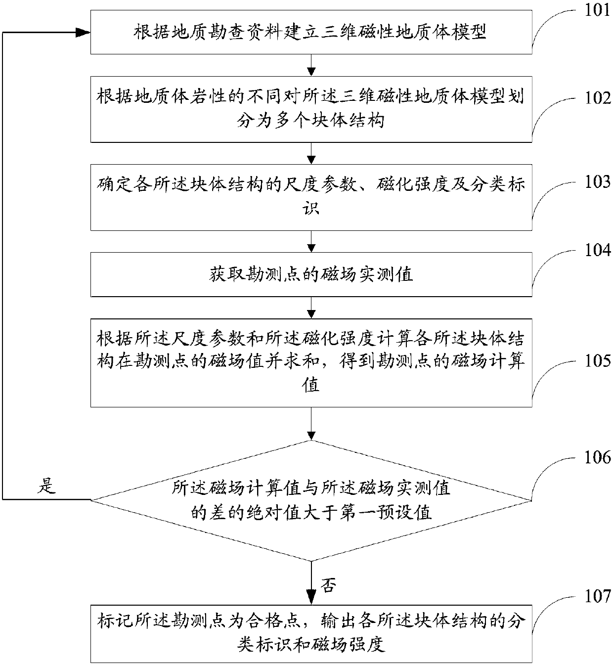
[0062] figure 1 It is a flow chart of the method for separating an aeromagnetic anomaly field in Embodiment 1 of the present invention, as figure 1 As shown, the aeromagnetic anomaly field separation method includes:

[0063] Step 101, establishing a three-dimensional magnetic geological body model according to the geological survey data;

[0064] Step 102, divide the three-dimensional magnetic geological body model into multiple block structures according to the different lithology of the geological body; optionally, the block structure is a cuboid, and the scale parameters of the block structure include length and width and high.

[0065] Step 103, determining the scale parameters, magnetization and classification marks of each of the block structures; the classification marks are assigned according to the lithology naming results of three-dimensional geological bodies, and used as the classification marks of different geological bodies; the magnetization is based on the s...

Embodiment 2

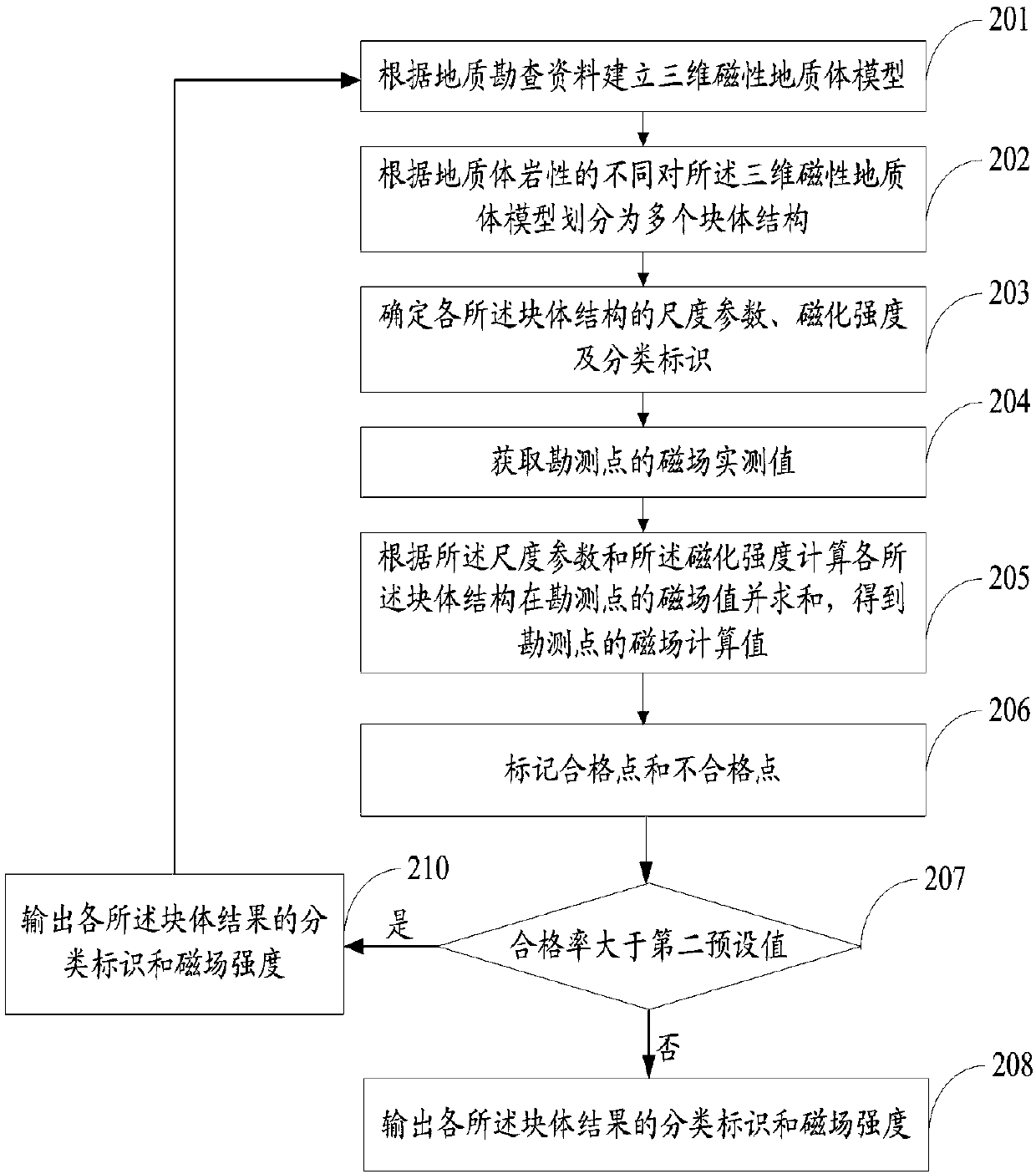
[0072] figure 1 It is a flow chart of the method for separating the aeromagnetic anomaly field in Embodiment 2 of the present invention, as figure 1 As shown, the aeromagnetic anomaly field separation method includes:

[0073] Step 201, establishing a three-dimensional magnetic geological body model according to geological survey data, specifically includes the following steps:

[0074] Step A1: Determine the initial value of the buried depth of the top and bottom of the magnetic geological body according to the exploration profile of the exploration line, the histogram of the mine borehole and the magnetic measurement results of the core.

[0075] Step A2, determining the plane distribution range of the magnetic geological body according to the remote sensing image and the geological map.

[0076] Step A3, according to the initial buried depth of the top and bottom surfaces of the magnetic geological body and the planar distribution range of the magnetic geological body, de...

Embodiment 3

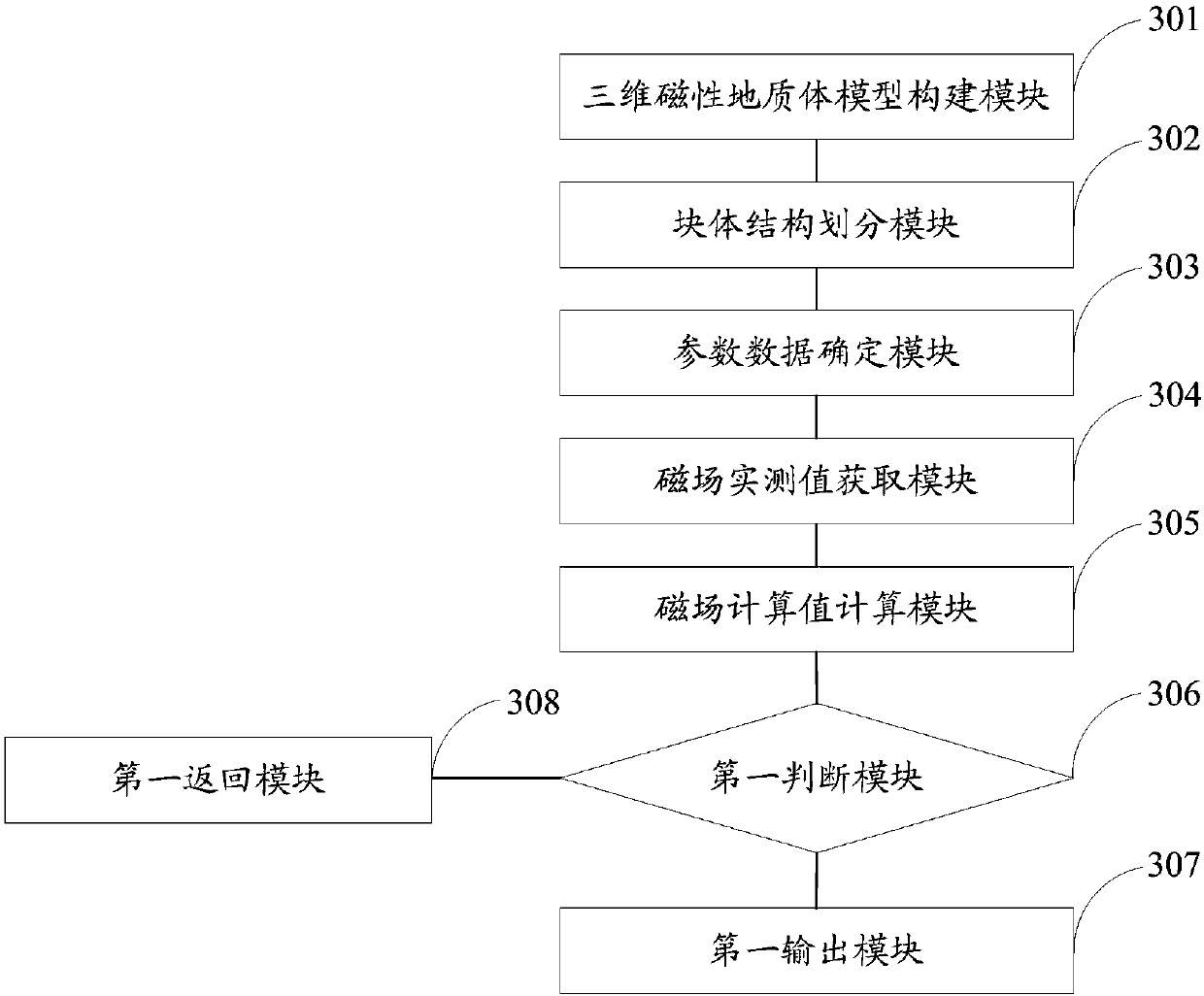
[0090] The present invention also provides an aeromagnetic anomaly field separation system based on three-dimensional geological modeling, image 3 It is the structural connection diagram of the aeromagnetic anomalous field separation system in Embodiment 3 of the present invention, as image 3 As shown, the aeromagnetic anomalous field separation system includes:

[0091] The three-dimensional magnetic geological body model construction module 301 is used to establish a three-dimensional magnetic geological body model according to geological exploration data.

[0092] Optionally, the three-dimensional magnetic geological body model construction module 301 specifically includes:

[0093]The initial value determination unit of the top and bottom surface of the magnetic geological body is used to determine the initial value of the top and bottom surface of the magnetic geological body according to the exploration profile diagram of the exploration line, the columnar diagram of ...


PUM


Abstract

The present invention discloses a three-dimensional geological modeling-based aeromagnetic anomalous field separation method and system. The aeromagnetic anomalous field separation method comprises the steps of firstly establishing a three-dimensional magnetic geologic body model, then dividing the three-dimensional magnetic geologic body model into a plurality of block body structures, calculating the magnetic field values of the block body structures at an exploration point and summing to obtain a magnetic field calculation value of the exploration point; when the absolute value of the difference of the magnetic field calculation value and a magnetic field actual measurement value is greater than a first preset value, reconstructing the three-dimensional magnetic geologic body model until the absolute value of the difference of the magnetic field calculation value and the magnetic field actual measurement value is less than or equal to the first preset value, and outputting the classification identifiers of the block body structures and the magnetic field intensity. According to the present invention, the magnetic field forward calculation is carried out according to the deductive lithologic structural maps obtained by the qualitative analysis more, and by comparing the aeromagnetic field forward calculation results and the actual measurement results, the new geological constraint conditions are added continuously during a model correction process, so that the modeling results are more reliable, and the aeromagnetic anomalous field separation precision is improved.

Description

technical field [0001] The invention relates to the field of aeromagnetic anomalous fields, in particular to a method and system for separating aeromagnetic anomalous fields based on three-dimensional geological modeling. Background technique [0002] With the rapid development of my country's economy, the demand for mineral resources is increasing, surface mines, shallow mines and easily identifiable mines are decreasing day by day. The problem of deep mine prospecting in old mines needs to be solved urgently. An important task in the current mineral forecasting work. There are huge difficulties in the exploration of potential mineral resources in mine bases. Since many old mines are located in complex mountainous areas and there are many industrial facilities on the surface, it is difficult to carry out ground geophysical prospecting work. There is an urgent need for fast and effective airborne geophysical prospecting technology to provide deep and surrounding geological p...

Claims


Application Information

Patent Timeline
IPC IPC(8): G01V3/08
CPCG01V3/081
Inventor 熊盛青于长春侯征
Owner CHINA AERO GEOPHYSICAL SURVEY & REMOTE SENSING CENT FOR LAND & RESOURCES
Why Eureka
Try Eureka