Single base station long-distance maritime real-time dynamic positioning method

A real-time dynamic positioning, long-distance technology, applied in satellite radio beacon positioning systems, instruments, measuring devices and other directions, can solve problems such as expensive and limited communication conditions

Active Publication Date: 2021-04-30
TONGJI UNIV
View PDF7 Cites 0 Cited by
  • Summary
  • Abstract
  • Description
  • Claims
  • Application Information

AI Technical Summary

Problems solved by technology

However, PPP technology is not only limited by communication conditions, but also requires expensive hardware network infrastructure support

Method used


Image

  • Single base station long-distance maritime real-time dynamic positioning method
  • Single base station long-distance maritime real-time dynamic positioning method
  • Single base station long-distance maritime real-time dynamic positioning method

Examples


Embodiment Construction

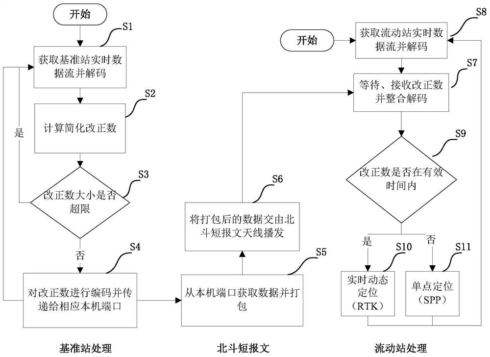
[0061] The specific implementation manner of the present invention will be described in more detail below with reference to schematic diagrams. Advantages and features of the present invention will be apparent from the following description and claims. It should be noted that all the drawings are in a very simplified form and use imprecise scales, and are only used to facilitate and clearly assist the purpose of illustrating the embodiments of the present invention.

[0062] An embodiment of the present invention provides a single base station long-distance maritime real-time dynamic positioning method, specifically, as figure 1 as shown, figure 1 It is a flow chart of a single base station long-distance marine real-time dynamic positioning method in an embodiment of the present invention. The method includes the following steps: first, receive the RTCM format data stream of the reference station in real time at the server end, and decode it to obtain the ephemeris The data ...


PUM


Abstract

The present invention provides a method for real-time dynamic positioning of a single base station at sea at long distances. The short message function of the Beidou navigation system is used to transmit the simplified differential correction number, which solves the problem of inconvenient or even no communication at sea. Based on multiple frequencies and multiple observation values ​​of a satellite navigation system, a stable, fast, and accurate real-time positioning algorithm for mobile terminals has been developed for the special environment at sea, and finally the corresponding base station correction number broadcasting software and mobile station real-time positioning software have been realized. , and built a set of long-distance marine real-time dynamic positioning system based on single base station.

Description

technical field [0001] The invention relates to the field of GNSS precise positioning, especially long-distance high-precision real-time dynamic positioning at sea. Background technique [0002] Since the advent of the GPS system, the Global Navigation Satellite System (GNSS) has been widely used in various outdoor positioning and navigation applications. Real-time high-precision positioning is an important research field of GNSS. At present, real-time kinematic (RTK) technology, precise point positioning (PPP) technology and their extended network RTK technology and PPP-RTK technology are representatives of high-precision GNSS positioning technology. However, these technologies have their own shortcomings in marine applications. [0003] PPP technology requires precise ephemeris, precise clock and other information, and these information are released on a specific website with a delay of about one week. As for some ultra-fast precise ephemeris and real-time precise ephem...

Claims


Application Information

Patent Timeline
Patent Type & Authority Patents(China)
IPC IPC(8): G01S19/42G01S19/44
CPCG01S19/425G01S19/44
Inventor 李博峰张治腾
Owner TONGJI UNIV
Why Eureka
Try Eureka