Barrier dam formation evaluation method based on water flow erosion capability

A technology of water flow and capacity, which is applied in the evaluation field of potential landslides or landslides forming dams, can solve the problems of landslide soil erosion to the downstream, soil cannot be accumulated, and the quantitative relationship of water erosion capacity has not been discussed, and the evaluation method is simple , effective forecasting, and the effect of easy calculation parameters

Active Publication Date: 2018-05-29
INST OF MOUNTAIN HAZARDS & ENVIRONMENT CHINESE ACADEMY OF SCI
View PDF6 Cites 10 Cited by
  • Summary
  • Abstract
  • Description
  • Claims
  • Application Information

AI Technical Summary

Problems solved by technology

[0003] Whether the landslide soil enters the river channel to form a barrier dam can be mainly divided into three situations: 1. The landslide soil enters the river channel, and the soil body is carried downstream by the river flow, and the soil cannot be accumulated in the river channel; 2. The landslide soil mass Entering the river, part of the soil is carried downstream by the river flow, and part of the soil is accumulated in the river, gradually forming a dam. However, it is continuously washed by the river flow. The water flow is carried downstream; 3. The landslide soil enters the river, and the river flow cannot immediately wash the landslide soil accumulated in the river to the downstream, and the landslide soil gradually forms a dam
It can be known from the situation that the landslide soil enters the river channel to form a barrier dam. If the water flow cannot immediately carry the landslide soil to the downstream, the landslide soil will not be affected by the water flow, and can be smoothly accumulated in the river channel and form a barrier dam. Therefore The erosive ability of water flow to soil is the key factor affecting whether the landslide soil will form a barrier dam after entering the river, but there is no quantitative relationship between the erosive ability of water flow to soil and the formation of dams. It is impossible to effectively assess whether the landslide soil will form a barrier dam

Method used


Image

  • Barrier dam formation evaluation method based on water flow erosion capability
  • Barrier dam formation evaluation method based on water flow erosion capability
  • Barrier dam formation evaluation method based on water flow erosion capability

Examples


Embodiment 1

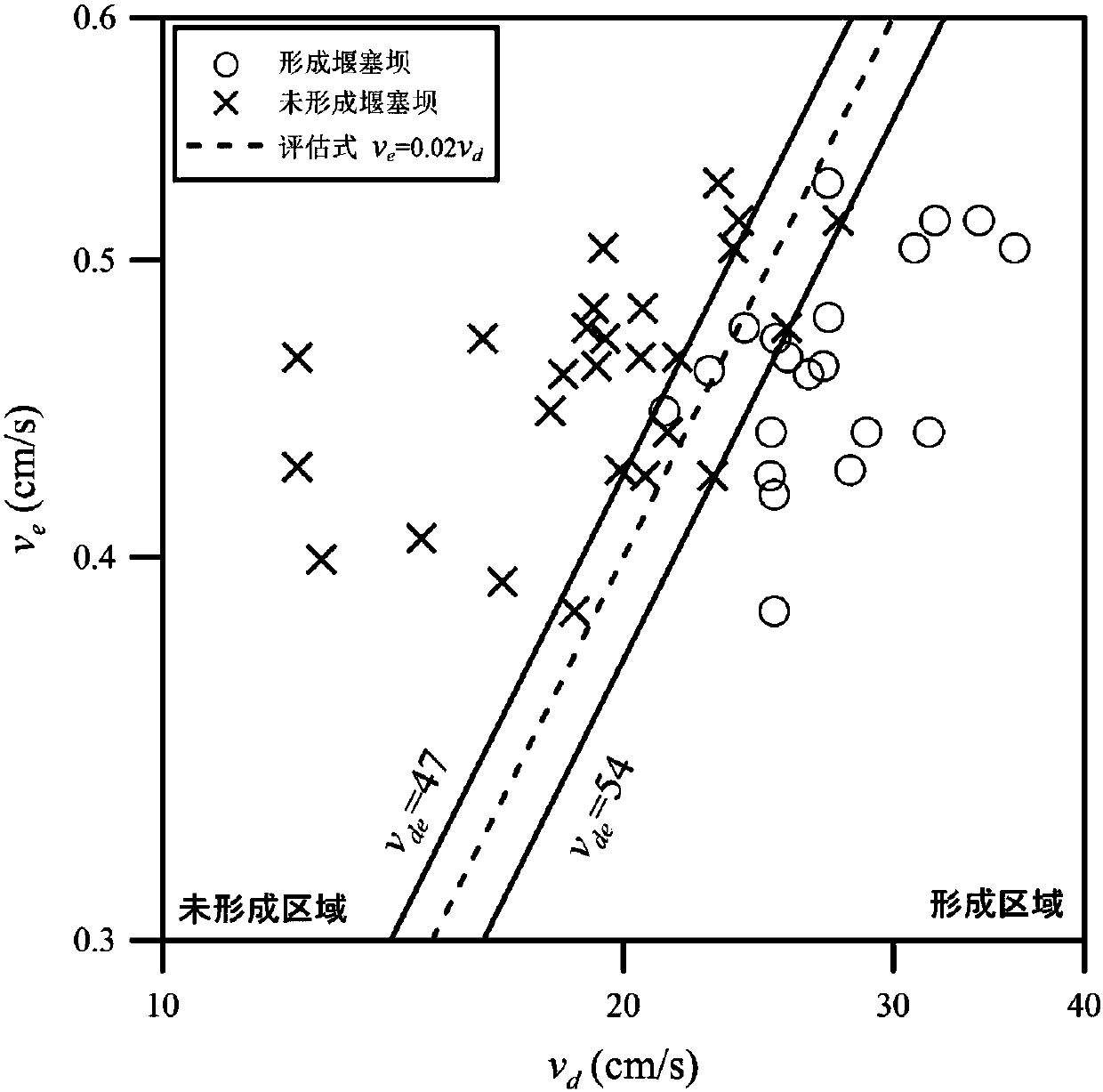
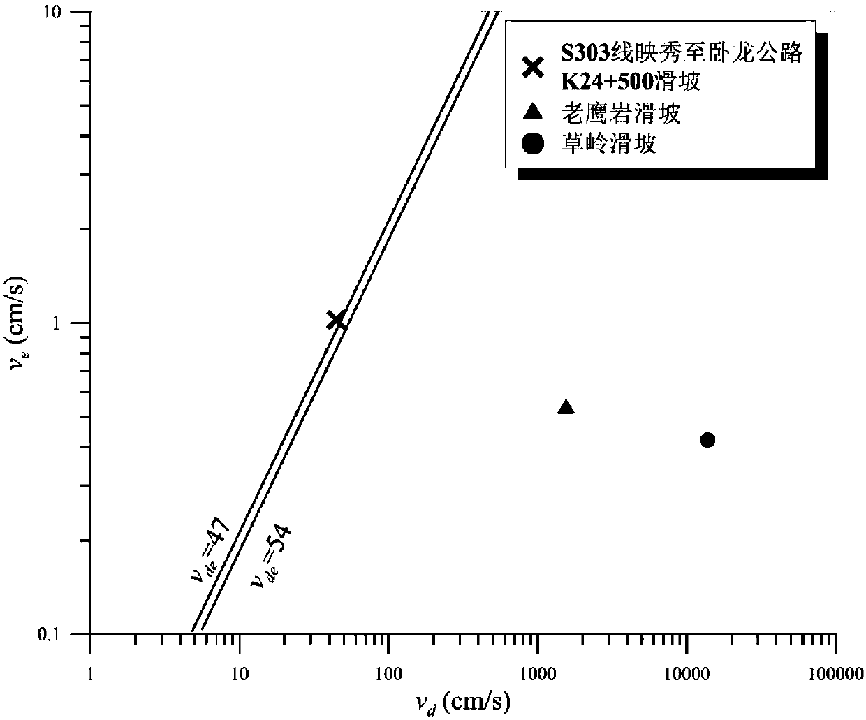
[0040] Such as figure 2 shown. The Laoyingyan landslide is one of the cases where the "5.12" Wenchuan Earthquake triggered landslides to form a barrier dam. It is located in the northwest of Quanshui Village, Gaochuan Township, An County, Mianyang City, Sichuan Province, with geographical coordinates N31°37′20.4″, E104°08′25.92″, After the Laoyingyan landslide occurred, a high-speed debris flow rushed into the Huangdongzi Valley and completely blocked it, forming a barrier dam with a height of 105m and a crest width of 150m. Ten days after the Wenchuan earthquake, the water storage capacity of the Laoyingyan barrier dam Has reached 2200000m 3 , The landslide not only formed a huge barrier dam, but also buried the Eagle Rock Power Station as a whole, resulting in the death of more than 20 people and economic losses of nearly 10 million yuan.

[0041] Adopt the method for evaluating the formation of the barrier dam based on the water erosion ability of the present invention t...

Embodiment 2

[0052] Such as figure 2 shown. The K24+500 landslide on the S303 Yingxiu-Wolong highway occurred on May 13, 2008. It is a case of a landslide that did not form a barrier dam. The S303 Yingxiu-Wolong highway K24+500 landslide is located in Gengda Town, Wenchuan County. On the left side of the road, on the right bank of Yuzixi River. After the landslide occurred, the landslide soil rushed into the Yuzixi River. Due to the turbulent flow of the Yuzixi River, most of the landslide soil was quickly eroded and transported by the river, which did not block the river to form a dam, but damaged the cable bridge across the river. And buried the Yingxiu-Wolong highway opposite the landslide location, causing the highway to be interrupted.

[0053] Adopt the formation evaluation method of the barrier dam based on the water flow erosion ability of the present invention to evaluate and verify that the landslide of the K24+500 road from Yingxiu to Wolong on the S303 line does not form a b...

Embodiment 3

[0064] Such as figure 2 shown. On September 21, 1999, a 7.3-magnitude earthquake occurred in Taiwan, China. The earthquake induced a landslide on the mountain slope near Caoling Village, Gukeng Township, Yunlin County. After the formation, the dam body height of 50-100m was formed, and the barrier lake did not cause serious secondary disasters. During the subsequent typhoon and heavy rain events, the lake area of ​​the barrier lake was gradually silted up, and it is now full of soil and sand.

[0065] Using the method for evaluating the formation of barrier dams based on water erosion capacity of the present invention, the formation of barrier dams for potential landslides in Caoling is evaluated and verified, and the specific steps are as follows:

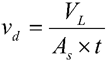
[0066] The first step is to obtain the location of the potential landslide in Caoling through the pre-earthquake remote sensing data. Determine the potential landslide area A through remote sensing and terrain data L 4000000m ...


PUM


Abstract

The invention discloses a barrier dam formation evaluation method based on the water flow erosion capability. According to the barrier dam formation evaluation method, an area, a slope, a height, a slope surface length, a slope surface width, a riverway width, and a riverway slope of a potential landslide position are determined based on remote sensing and terrain data; a soil mass stacking rate of a potential landslide and a riverway water flow erosion rate are calculated respectively; and then whether the potential landslide soil mass will block a main riverway to form a barrier dam is determined based on a dimensionless rate index. Compared with the prior art, the method considers the landslide soil mass parameter and water flow parameter comprehensively and provides a dimensionless rate index, so that whether the potential landslide soil mass will block a main riverway to form a barrier dam is evaluated reasonably and thus effective prediction of the barrier dam formation possibility is realized. Moreover, the computing parameter is easy to obtain and the evaluation method is simple; and a scientific basis is provided for evaluation of the possibility of formation of a barrierdam by the potential landslide soil mass.

Description

technical field [0001] The invention relates to a method for assessing the formation of a barrier dam based on water erosion ability, in particular to an assessment method suitable for potential landslides or barrier dams formed by landslides. Background technique [0002] Barrier dams are formed by volcanic lava flows, moraines, or landslides and landslides caused by geological disasters and seismic activities that cause mountain rocks to collapse and block mainstream rivers, forming a water retaining body similar to a dam. Among them, the barrier dam formed by the landslide is controlled by the basic characteristics of the landslide and the hydrological conditions of the river. For valleys with steep slopes and small channel widths, after a landslide occurs, the movement of the soil is sufficient to move to the channel or reach the opposite bank. When the river flow cannot immediately wash the landslide soil accumulated in the channel downstream, And when the water flow d...

Claims


Application Information

Patent Timeline
Patent Type & Authority Applications(China)
IPC IPC(8): G06Q10/06G06Q50/00
CPCG06Q10/06393G06Q50/00
Inventor 陈昆廷陈晓清游勇胡桂胜
Owner INST OF MOUNTAIN HAZARDS & ENVIRONMENT CHINESE ACADEMY OF SCI
Why Eureka
Try Eureka