Hail damage remote sensing monitoring method for agricultural insurance claims

A technology of remote sensing monitoring and crops, applied in the application of remote sensing technology in hail disaster monitoring, and the application field of remote sensing technology in agricultural insurance, which can solve the problems of information asymmetry, low efficiency of loss assessment, and many disputes in claim settlement, so as to improve business Regulatory capacity, the effect of addressing information asymmetry

Active Publication Date: 2018-08-17
阳光农业相互保险公司
View PDF6 Cites 10 Cited by
  • Summary
  • Abstract
  • Description
  • Claims
  • Application Information

AI Technical Summary

Problems solved by technology

[0003] The purpose of the present invention is to solve the problems of information asymmetry, low efficiency of loss determination and many claims disputes in the process of traditional agricultural insurance survey and loss determination, and to provide a remote sensing monitoring method for crop hail disasters for agricultural insurance claims

Method used


Image

  • Hail damage remote sensing monitoring method for agricultural insurance claims
  • Hail damage remote sensing monitoring method for agricultural insurance claims
  • Hail damage remote sensing monitoring method for agricultural insurance claims

Examples


Embodiment

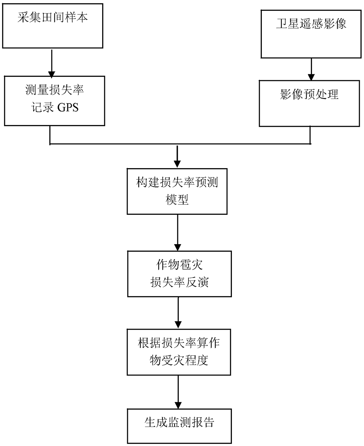
[0039] Step 1. Download the multispectral remote sensing images before and after the occurrence of the hail disaster, and perform preprocessing;

[0040] The multi-spectral image is obtained through the sensor, and the basic image processing procedures such as orthorectification, geometric correction, and atmospheric correction are performed on it.

[0041] Step 2. Sampling the loss rate of the fields within the range of the hail disaster, and recording the GPS of the sampling points;

[0042] The bid inspector shall go to the land affected by hail with GPS to take samples. The sampling point shall be at least 10 meters away from the border of the land. Record the location of the collection point on the insured land on the bid inspection form, and measure the crop loss rate at this point:

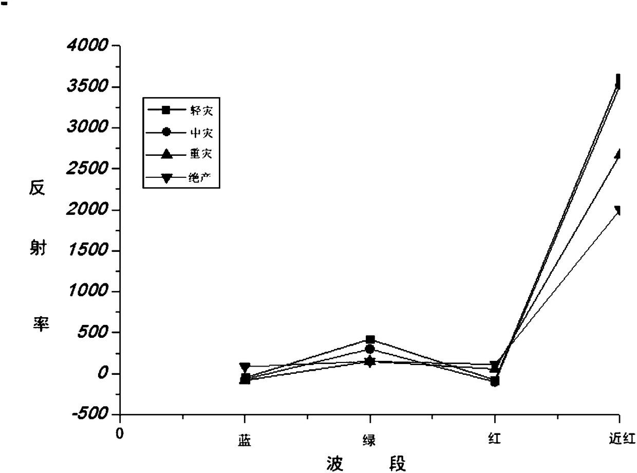
[0043] The main loss rate calculation formulas are as (1)-(3):

[0044] Loss rate = 1-measured production yield / insured yield (1)

[0045] Yield yield = number of ears per mu × number of ...


PUM


Abstract

The invention discloses a hail damage remote sensing monitoring method for agricultural insurance claims, relates to a damage remote sensing monitoring technology, and concretely relates to an application of the remote sensing technology in hail damage monitoring and an application of the remote sensing technology in agricultural insurance. The problems of information asymmetry, low loss assessment efficiency and many claims disputes in traditional agricultural insurance survey and loss assessment working processes are solved in the invention. The remote sensing monitoring method includes thefollowing steps: 1, obtaining a reflection spectrum; 2, performing spot test on the crop loss rate, and recording the GPS information of a sampling point; 3, constructing a multiple linear regressionmodel; 4, inverting the loss rate of a hail damage land; and 5, performing claim settlement on the land with loss rate in a hail damage range of 30% or more. The remote sensing technology is combinedwith a traditional agricultural insurance survey and loss assessment working mode to create a novel remote sensing technology application mode and a novel survey and loss assessment mode.

Description

technical field [0001] The invention relates to disaster remote sensing monitoring technology, in particular to the application of remote sensing technology in hail disaster monitoring and the application of remote sensing technology in agricultural insurance. Background technique [0002] With the expansion of agricultural insurance scale, agricultural insurance operation is facing the paradox of efficiency and risk management. The prominent manifestations are information asymmetry, moral hazard and low efficiency of claim settlement, which seriously restrict the performance of agricultural insurance's economic compensation, financial integration and social management functions. At present, when a claim event caused by a hail disaster occurs, the traditional agricultural insurance, during the growth period of the crops, the staff often use random fixed-point sampling in the field to investigate and determine the damage after the hail disaster occurs. The area affected by t...

Claims


Application Information

Patent Timeline
Patent Type & Authority Applications(China)
IPC IPC(8): G01N21/25G01S19/42
CPCG01N21/25G01S19/42
Inventor 康健宁东浩孙思雨
Owner 阳光农业相互保险公司
Why Eureka
Try Eureka