Crop Yield Estimation Method Based on Data Assimilation of Dual Polarization Synthetic Aperture Radar and Crop Model

An aperture radar and model data technology, applied in the field of agricultural remote sensing, can solve problems such as high-precision estimation of crop yield in difficult areas, and achieve the effect of overcoming the lack of optical remote sensing data and improving simulation accuracy.

Active Publication Date: 2021-10-08
金智农(北京)风险管理科技有限公司
View PDF7 Cites 0 Cited by
  • Summary
  • Abstract
  • Description
  • Claims
  • Application Information

AI Technical Summary

Problems solved by technology

These methods are difficult to achieve high-precision estimation of regional crop yield due to their inherent limitations.

Method used


Image

  • Crop Yield Estimation Method Based on Data Assimilation of Dual Polarization Synthetic Aperture Radar and Crop Model
  • Crop Yield Estimation Method Based on Data Assimilation of Dual Polarization Synthetic Aperture Radar and Crop Model
  • Crop Yield Estimation Method Based on Data Assimilation of Dual Polarization Synthetic Aperture Radar and Crop Model

Examples


Embodiment 1

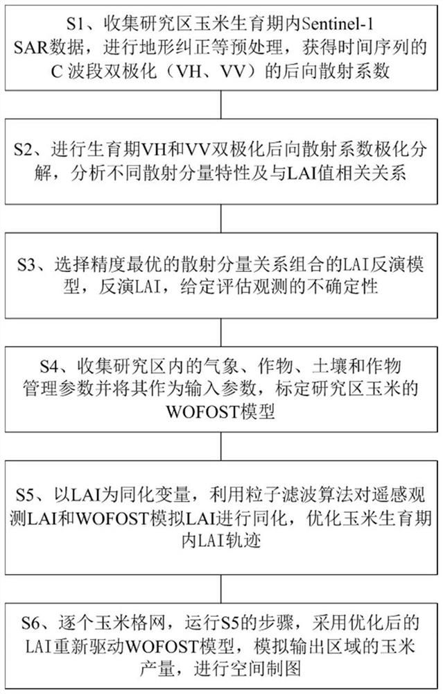
[0053] For the flow chart of the crop yield estimation method for corn yield estimation using the dual-polarization synthetic aperture radar and crop model data assimilation of the present invention, please refer to the attached figure 1 .

[0054] S1 collects Sentinel-1 data during the maize growth period in the study area, performs preprocessing such as terrain correction, and obtains the backscatter coefficients of the two polarizations (VH, VV) of the time series C band, that is, dual-polarization SAR data;

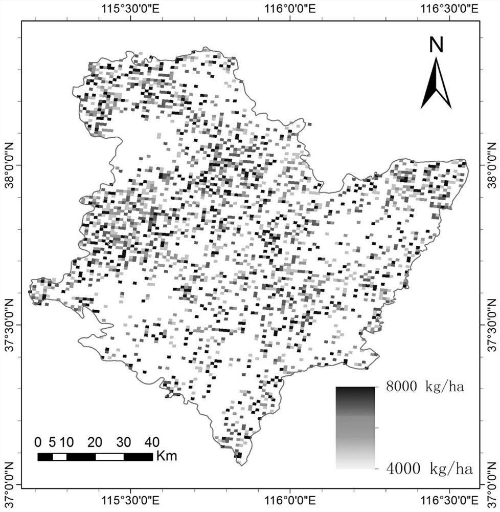
[0055] Hengshui City, Hebei Province was selected as the research area, which is located between 115°10′-116°34′ east longitude and 37°03′-38°23′ north latitude. The total area of ​​the study area is 8815km2, the terrain is mainly plains, and the cultivated land accounts for more than 60% of the total area. It belongs to the warm temperate semi-humid monsoon climate, with annual sunshine hours of 2400-3100h and annual average precipitation of 300-800mm.

[0056] The ...


PUM


Abstract

The invention belongs to the field of agricultural remote sensing, and relates to a method for estimating crop yield by assimilating dual-polarization synthetic aperture radar and crop model data. The data is polarized and decomposed, and the LAI inversion model with the highest accuracy of the combination of scattering components is selected for inversion to obtain the remote sensing observation LAI; the WOFOST model LAI of the crops in the research area is calibrated; the two LAIs are assimilated using the particle filter algorithm; The network uses the optimized LAI trajectory of the crop growth period to re-drive the WOFOST model for spatial mapping. The method of the present invention combines the advantages of SAR remote sensing data and crop models, fully utilizes the rich information provided by multi-polarization SAR data, overcomes the problem of lack of optical remote sensing data in the key growth period of corn, and improves the yield simulation and accuracy of crop models. The LAI trajectory during the crop growth period is optimized, and crop yield can be estimated on a regional scale.

Description

technical field [0001] The invention belongs to the field of agricultural remote sensing, and in particular relates to a method for estimating crop yield by assimilating dual-polarization synthetic aperture radar and crop model data. Background technique [0002] Traditional crop yield estimation methods mainly include statistical survey methods, crop model-based forecast methods, and agrometeorological forecast methods. These methods are difficult to achieve high-precision estimation of regional crop yield due to their inherent limitations. The estimation method based on satellite remote sensing technology has unique advantages in regional crop yield estimation by virtue of its spatial continuity and temporal dynamic characteristics. At the same time, the combination of remote sensing technology and crop growth models based on crop photosynthesis, respiration, transpiration, nutrition and other mechanism processes can achieve the purpose of regional high-precision yield es...

Claims


Application Information

Patent Timeline
Patent Type & Authority Patents(China)
IPC IPC(8): G06K9/00
CPCG06F2218/20G06F2218/04
Inventor 黄健熙李俐卓文朱德海张晓东苏伟刘峻明刘哲
Owner 金智农(北京)风险管理科技有限公司
Why Eureka
Try Eureka