Intelligent understanding method of land use change, based on multi-temporal remote sensing images

A remote sensing image and multi-temporal technology, which is applied in the field of computer vision and image semantic understanding, can solve the problem of expressing ground object knowledge in the form, detection accuracy is not high, and it is difficult to effectively use high-resolution remote sensing image geometry, shape, semantics, etc. Information and other issues, to achieve the effect of deep understanding and accurate change detection

Active Publication Date: 2018-11-06
CENT SOUTH UNIV
View PDF7 Cites 8 Cited by
  • Summary
  • Abstract
  • Description
  • Claims
  • Application Information

AI Technical Summary

Problems solved by technology

[0004] The purpose of the present invention is to provide an intelligent understanding method of land use change based on multi-temporal remote sensing images to solve the problem that traditional remote sensing image change detection is difficult to effectively use

Method used


Image

  • Intelligent understanding method of land use change, based on multi-temporal remote sensing images

Examples


Embodiment Construction

[0034] The embodiments of the present invention will be described in detail below with reference to the accompanying drawings, but the present invention can be implemented in various ways defined and covered by the claims.

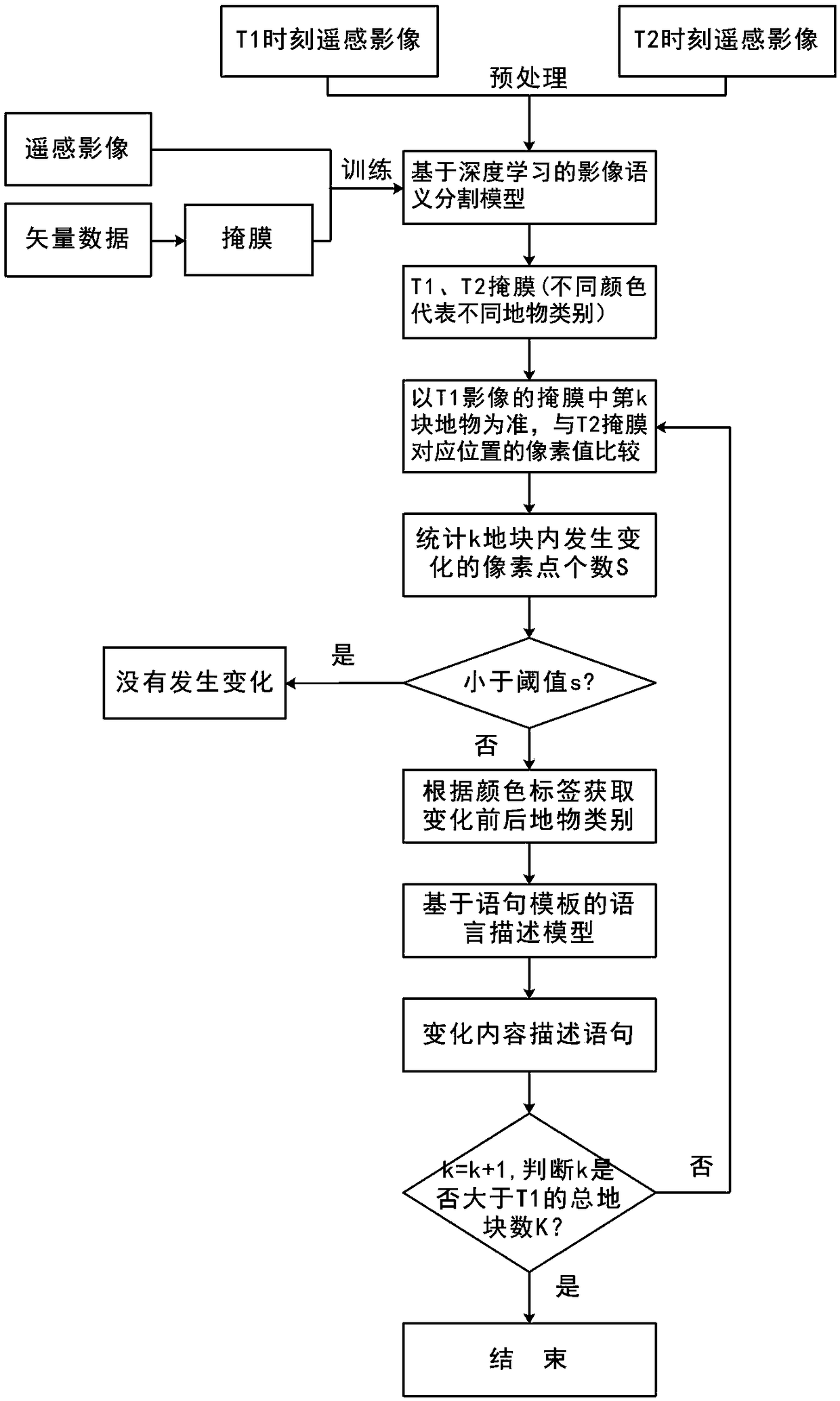
[0035] An intelligent understanding method of land use change based on multi-temporal remote sensing images, including detecting changed objects in a two-temporal target area and describing the changed content in natural language.

[0036] Detecting the changed object in the two-temporal target area specifically includes the following steps:

[0037] Step A1: Obtain remote sensing data of two temporal phases. Specifically, remote sensing images of the target area at time T1 and time T2 are obtained, as well as vector data correspondingly matched with the remote sensing images. Generally, it can be obtained by at least one of the Internet open source crowd source OSM data, the land department and the surveying and mapping department. The vector data refle...


PUM


Abstract

The invention provides an intelligent understanding method of land use change, based on multi-temporal remote sensing images. The intelligent understanding method of land use change, based on multi-temporal remote sensing images includes the steps: detecting objects which are changed in the two-temporal remote sensing image target area and the content of the changes described by natural language,wherein detection of the objects which are changed in the two-temporal remote sensing image target area includes acquisition of the data of two-temporal, preprocessing of the remote sensing images, blocked cutting of the two-temporal data, construction of a mask layer, model training, model testing, detection of the content which is changed, and highlighting of the changed blocks; and the contentof the changes described by natural language includes determination of statement templates for describing the content of changes, and generation of description statement. The intelligent understandingmethod of land use change, based on multi-temporal remote sensing images respectively segments the two-temporal remote sensing images, uses the natural object class information to determine the change of the same position natural object class, is more accurate in change detection, is deterministic in the described content, describes the content of changes by the natural language, visually displays the content of changes of the two-temporal images, and is convenient for deep understanding of remote sensing images.

Description

technical field [0001] The invention relates to the technical field of computer vision and image semantic understanding, in particular to an intelligent understanding method of land use change based on multi-temporal remote sensing images. Background technique [0002] Remote sensing images are an important data source for the management and utilization of land resources. Quickly and automatically locate data with information differences from massive data, and dig out hidden information in remote sensing images, which can save a lot of manpower and material resources, and is of great significance to the effective use of land resources and scientific decision-making of relevant departments . Traditional remote sensing image change detection is usually based on spectral and other features to detect and judge whether the ground objects at the same location have changed. It is difficult to effectively use high-level information such as geometry, shape, and semantics in high-res...

Claims


Application Information

Patent Timeline
IPC IPC(8): G01S13/89
CPCG01S13/89
Inventor 陈杰周兴韩雅荣何玢万里邓敏
Owner CENT SOUTH UNIV
Why Eureka
Try Eureka