Remote sensor radiometric calibration method based on hyperspectral data and calibration system

A hyperspectral remote sensing and radiation calibration technology, which is applied in the field of remote sensor radiation calibration methods and calibration systems, can solve problems such as different processing methods and inability to meet cross-calibration requirements for visible spectrum segments

Active Publication Date: 2018-12-07
NAT SATELLITE METEOROLOGICAL CENT
View PDF2 Cites 11 Cited by
  • Summary
  • Abstract
  • Description
  • Claims
  • Application Information

AI Technical Summary

Problems solved by technology

In addition, the ground pixel of GOME-2 is a quadrilateral, which is different from the elliptical pixel of IASI in terms of spatial matching. The existing technology of cross-calibration of infrared spectrum cannot meet the cross-calibration of visible spectrum. Require

Method used


Image

  • Remote sensor radiometric calibration method based on hyperspectral data and calibration system
  • Remote sensor radiometric calibration method based on hyperspectral data and calibration system
  • Remote sensor radiometric calibration method based on hyperspectral data and calibration system

Examples


Embodiment 1

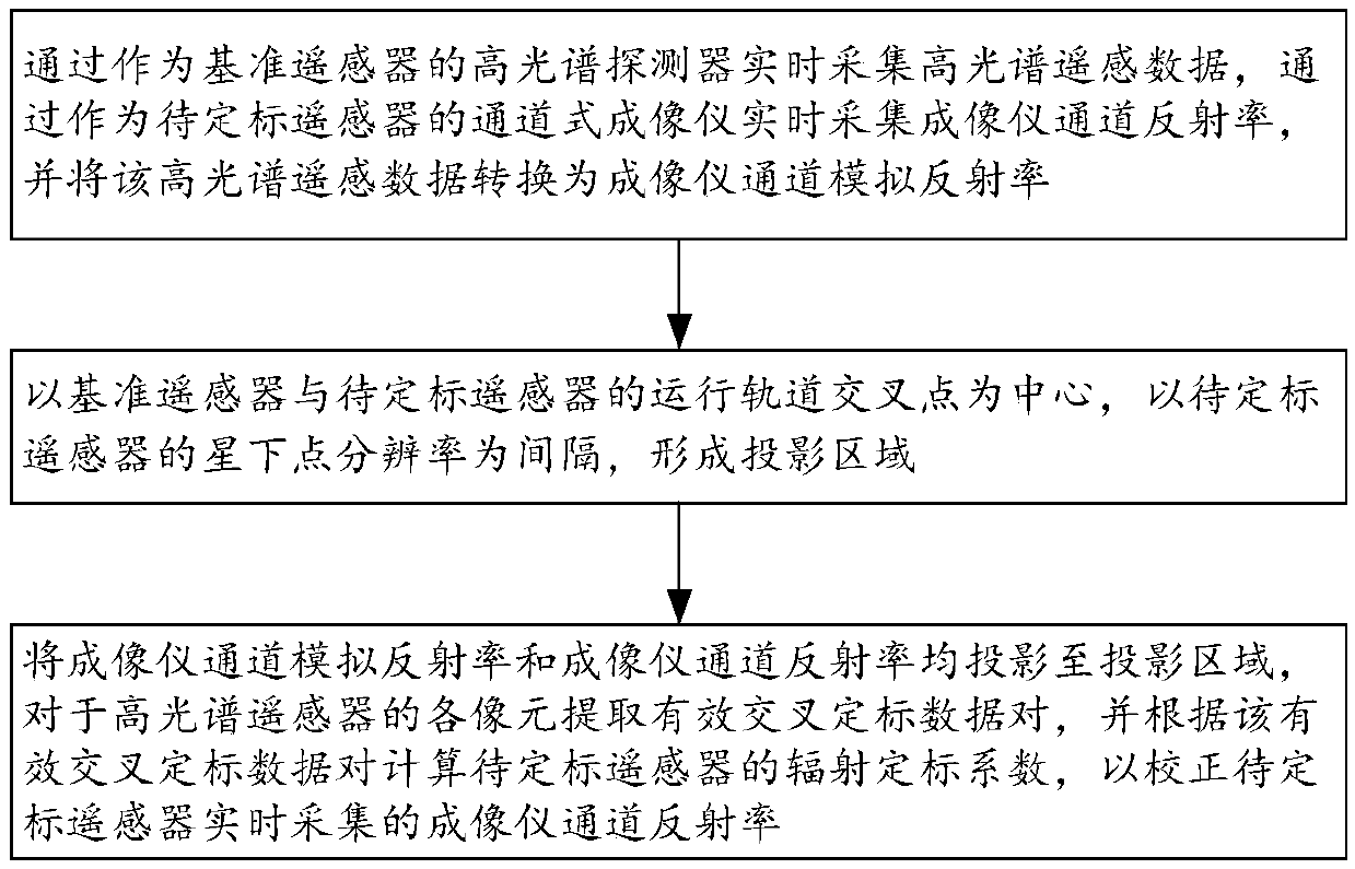
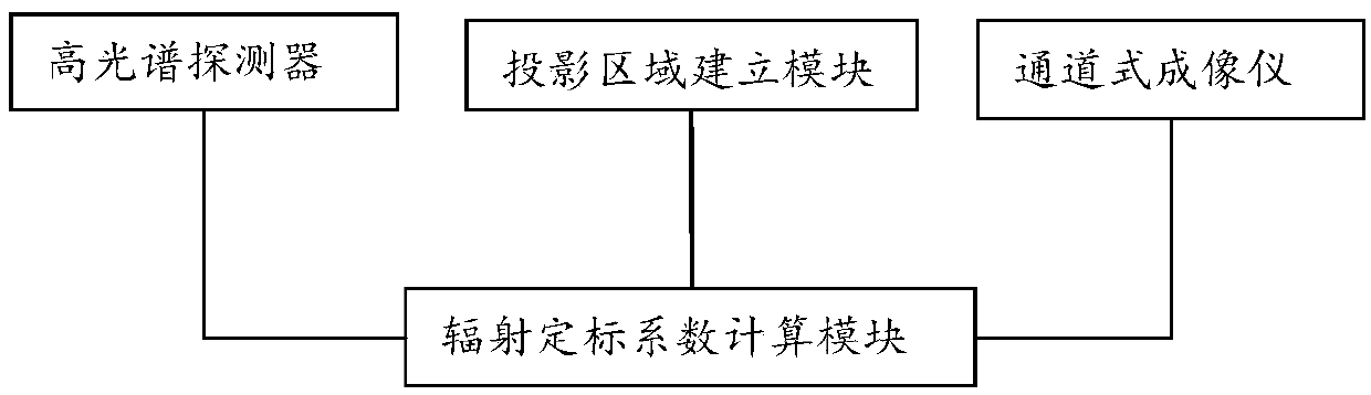
[0068] figure 1 It is a step diagram of a remote sensor radiation calibration method based on hyperspectral data according to an embodiment of the present invention, refer to figure 1 , the remote sensor radiation calibration method based on hyperspectral data in the embodiment of the present invention specifically includes the following steps: collecting hyperspectral remote sensing data in real time through a hyperspectral remote sensor as a reference remote sensor, and using channel imaging as a remote sensor to be calibrated The reflectance of the channel of the imager is collected by the instrument in real time, and the hyperspectral remote sensing data is converted into the simulated reflectance of the channel of the imager; the intersection point of the orbit of the reference remote sensor and the remote sensor to be calibrated is the center, and the sub-satellite position of the remote sensor to be calibrated is The point resolution is the interval, and the projection ...

Embodiment 2

[0144] In this embodiment, GOME-2 (The Second Global Ozone Monitoring Experiment, second-generation global ozone monitoring instrument) is used as the reference remote sensor, MERSI is used as the remote sensor to be calibrated, and the calibration coefficient of the remote sensor to be calibrated is calculated.

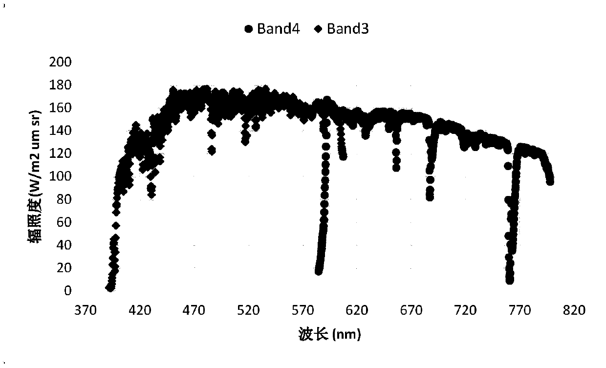
[0145]GOME-2 is mainly used to detect the total amount of global ozone column and ozone profile, and can also invert the total column amount of other atmospheric trace gases (such as NO2\BrO\OClO\CHO\SO2). GOME-2 has four main channels (channel), two polarization measurement units (Polaris Measurements Devices PMDs), and each main channel (channel) has a total of 1024 probes. The spectral detection range of the main channel is between 240nm and 790nm, and the spectral resolution is 0.26nm to 0.51nm. The L1 data of GOME-2 has the spectral radiance of each channel pixel and the spectral solar constant measured once per track. Among them, the wavelength range of the ma...


PUM


Abstract

The invention provides a remote sensor radiometric calibration method based on hyperspectral data and a calibration system. The method comprises the steps of collecting hyperspectral remote sensing data in real time through a hyperspectral remote sensor serving as a reference remote sensor, collecting the imager channel reflectivity in real time through a channel imager serving as a remote sensorto be calibrated, and converting the hyperspectral remote sensing data into imager channel simulated reflectivity; establishing a projection area by taking the interaction of running orbits of the reference remote sensor and the remote sensor to be calibrated as a center and taking the sub-satellite point resolution as an interval; and projecting the imager channel simulated reflectivity and the imager channel reflectivity to the projection area, extracting effective cross-calibration data pairs for pixels of the hyperspectral remote sensing data, and calculating the radiometric calibration coefficient of the remote sensor to be calibrated according to the effective cross-calibration data pairs so as to correct the imager channel reflectivity collected by the remote sensor to be calibratedin real time.

Description

technical field [0001] The invention relates to the technical field of on-orbit radiation calibration of remote sensors, in particular to a remote sensor radiation calibration method and calibration system based on hyperspectral data. Background technique [0002] High-precision radiometric calibration of remote sensing data is an important prerequisite for its quantitative application. The radiometric calibration of the visible-near-infrared band imager is generally preferred to be equipped with an on-board calibration device to complete the calibration. However, for remote sensors that are not equipped with an on-board absolute radiation calibration device, it is often necessary to use an alternative calibration method to complete the radiation calibration work during its working life. The cross-calibration method (Simultaneously Nadir Observe, SNO) based on the observation data of the sub-satellite point is currently a relatively common method for on-orbit radiometric ca...

Claims


Application Information

Patent Timeline
Patent Type & Authority Applications(China)
IPC IPC(8): G01J3/28
CPCG01J3/2823G01J2003/2826
Inventor 吴荣华胡秀清张鹏徐娜陈林王鹏
Owner NAT SATELLITE METEOROLOGICAL CENT
Why Eureka
Try Eureka