A Range Control Method for Spatial Data

A technology of spatial data and control method, applied in the field of spatial data, can solve the problems of inability to achieve real-time control of spatial data range, unable to cope with dynamic update of spatial data, etc., so as to improve data utilization efficiency, reduce data processing work, and realize spatial range. control effect

Active Publication Date: 2019-07-02
CHONGQING GEOMATICS & REMOTE SENSING CENT +1
View PDF7 Cites 0 Cited by
  • Summary
  • Abstract
  • Description
  • Claims
  • Application Information

AI Technical Summary

Problems solved by technology

[0008] However, the above method of controlling the range of spatial data adds additional data processing work, cannot cope with the dynamic update of spatial data, and cannot achieve real-time control of the range of spatial data

Method used


Image

  • A Range Control Method for Spatial Data
  • A Range Control Method for Spatial Data
  • A Range Control Method for Spatial Data

Examples


Embodiment Construction

[0031] In order to make the purpose, technical solutions and advantages of the embodiments of the present invention clearer, the technical solutions in the embodiments of the present invention will be clearly and completely described below in conjunction with the drawings in the embodiments of the present invention. Obviously, the described embodiments It is a part of embodiments of the present invention, but not all embodiments. Based on the embodiments of the present invention, all other embodiments obtained by persons of ordinary skill in the art without making creative efforts belong to the protection scope of the present invention.

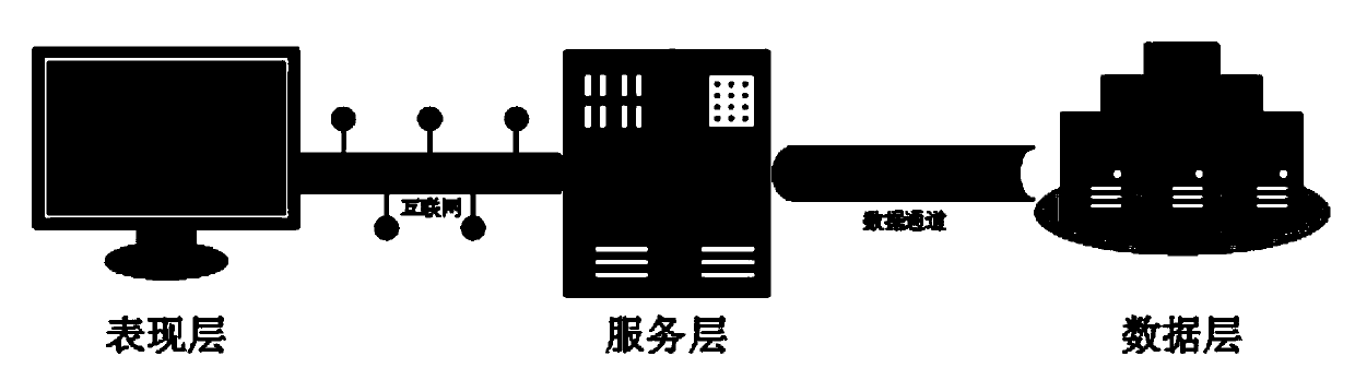
[0032] see figure 1 , is a schematic diagram of the architecture of the system adopted by the spatial data range control method provided by the embodiment of the present invention. The system adopts a three-layer architecture, which is respectively a presentation layer, a service layer and a data layer. The presentation layer adopts JavaScri...


PUM


Abstract

The invention discloses a method for range control of spatial data. The method includes the steps of generating a specific spatial range parameter according to different input query conditions, and carrying out spatial superposition operation on various spatial data by using the parameter, wherein a calculation result is the result of carrying out range restriction on the spatial data. The methodfor range control of the spatial data provided by the invention can update the control range of the spatial data in real time, reduce the data processing work and improve the data utilization efficiency.

Description

[0001] 1. Technical field [0002] The invention relates to the field of spatial data, in particular to a method for controlling the range of spatial data. [0003] 2. Background technology [0004] Spatial data refers to data with position coordinates, including vector data, remote sensing image data, etc. Vector data includes data of point, line, and area types. [0005] In the field of web map services, after the spatial data is usually configured with certain style information such as color, line type, and symbol, the map image is generated by the rendering system and displayed to the user, such as Google Map, Baidu Map, Gaode Map, etc., and the user can view all All spatial data in web services. [0006] Map spatial data has the characteristics of large data volume, high update frequency, and data confidentiality. When using spatial data to provide external services, do a good job of controlling the authority of the space and dynamically control the display range of spat...

Claims


Application Information

Patent Timeline
Patent Type & Authority Patents(China)
IPC IPC(8): G06F16/29G06F21/62
CPCG06F21/6227
Inventor 梁星李林袁超张泽烈邓仕虎王炜向其权刘洪波汤树林朱俊丰陈晓龙刘骏李仕峰梁均军曾诚
Owner CHONGQING GEOMATICS & REMOTE SENSING CENT
Why Eureka
Try Eureka