Indoor positioning and navigation method based on laser SLAM (Simultaneous Localization and Mapping)

An indoor positioning and laser technology, applied in the field of positioning and navigation, can solve problems such as indoor positioning, and achieve the effect of improving efficiency and accurate indoor positioning

Active Publication Date: 2018-12-11
GUANGDONG ELINK INFORMATION TECH
View PDF14 Cites 15 Cited by
  • Summary
  • Abstract
  • Description
  • Claims
  • Application Information

AI Technical Summary

Problems solved by technology

However, different places inside the building may be the same, for example, the distribution of the left and right functional rooms on the same floor is the same, the toilets on different floors are the same, etc.

Method used


Image

  • Indoor positioning and navigation method based on laser SLAM (Simultaneous Localization and Mapping)
  • Indoor positioning and navigation method based on laser SLAM (Simultaneous Localization and Mapping)
  • Indoor positioning and navigation method based on laser SLAM (Simultaneous Localization and Mapping)

Examples


Example Embodiment

[0054] Example

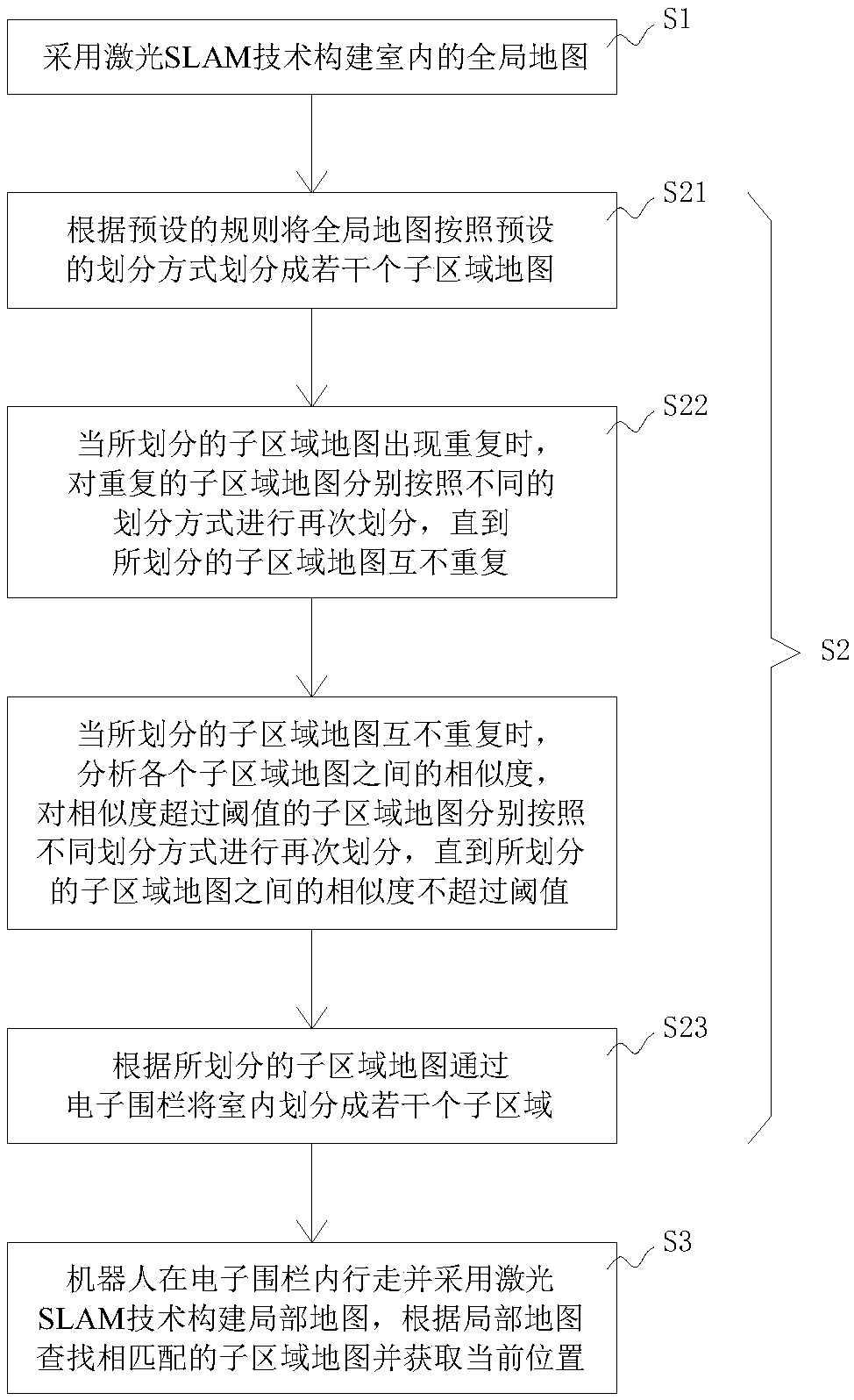
[0055] like figure 1 As shown, an indoor positioning method based on laser SLAM includes the following steps:

[0056] S1. Use laser SLAM technology to build an indoor global map;

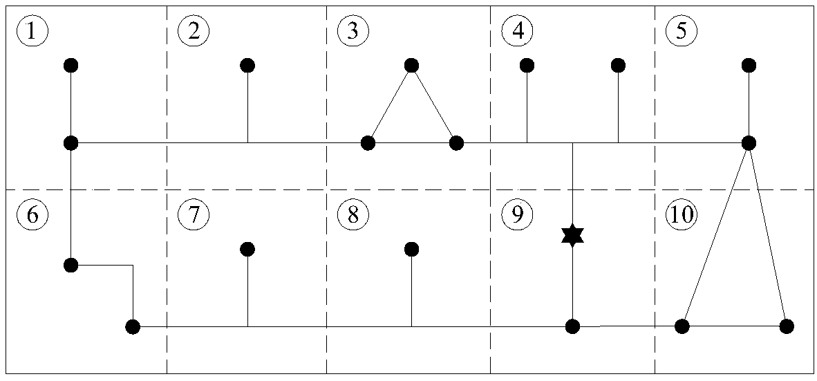
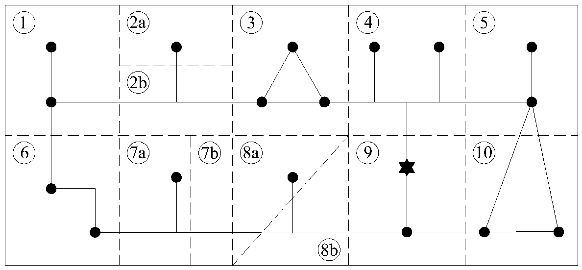
[0057] S2. Divide the global map into several non-repetitive sub-area maps, and divide the room into several sub-areas through electronic fences according to the divided sub-area maps;

[0058] S3. The robot walks in the electronic fence and uses the laser SLAM technology to construct a local map, finds the matching sub-region map according to the local map and obtains the current position.

[0059] Divide the global map into non-repetitive sub-region maps, that is, each sub-region map is unique. The electronic fence can divide the indoor into non-repetitive sub-areas according to the divided sub-area map. During the positioning process, the robot can only walk in one of the sub-areas and build a local map under the action of the electronic fence. The local map of the robot is ...


PUM


Abstract

The invention relates to an indoor positioning and navigation method based on laser SLAM (Simultaneous Localization and Mapping). The indoor positioning and navigation method comprises the following steps: S1, constructing an indoor global map by adopting a laser SLAM technology; S2, dividing the global map into a plurality of sub-region maps which are not repeated; dividing an indoor space into aplurality of sub-regions through an electronic fence according to divided sub-region maps; and S3, enabling a robot to walk in the electronic fence and constructing a local map by utilizing the laserSLAM technology, and looking up matched sub-region maps according to the local map and acquiring a current position. Even if the distribution of building structures and function sub-chambers of different indoor places is the same, accurate indoor positioning and navigation also can be realized.

Description

technical field [0001] The invention relates to the technical field of positioning and navigation, in particular to an indoor positioning and navigation method based on laser SLAM. Background technique [0002] In buildings with complex structures and many functional divisions, it is easy for people to lose their way and find the destination they want to go. At present, the commonly used positioning and navigation method is to use satellite positioning systems, such as GPS or Beidou, but because the positioning signals received by GPS or Beidou in indoor environments are weak, the positioning error is large, and sometimes even fails, so how to not Relying on the satellite positioning system to complete the accurate positioning of personnel indoors has become a difficult problem. [0003] Laser SLAM (simultaneous localization and mapping) is a technology for instant localization and map construction. It uses lidar to collect a series of scattered points with accurate angle a...

Claims


Application Information

Patent Timeline
IPC IPC(8): G01C21/20
CPCG01C21/206
Inventor 方妍何秋艳黄潇云陈晶陈锦银葛斌华
Owner GUANGDONG ELINK INFORMATION TECH
Why Eureka
Try Eureka