A method for automatic semantic segmentation of mine area in remote sensing image

A remote sensing image and semantic segmentation technology, applied in the field of automatic target detection and deep learning, can solve problems such as low efficiency, and achieve the effect of high work efficiency and high accuracy

Active Publication Date: 2019-01-04
合肥深蓝空间智能科技有限公司
View PDF4 Cites 18 Cited by
  • Summary
  • Abstract
  • Description
  • Claims
  • Application Information

AI Technical Summary

Problems solved by technology

[0004] The purpose of the present invention is to provide a method for automatic semantic segmentation of mining areas in remote sensing images, to solve the problem of low efficiency of the existing methods proposed in the above-mentioned background technology

Method used


Image

  • A method for automatic semantic segmentation of mine area in remote sensing image
  • A method for automatic semantic segmentation of mine area in remote sensing image
  • A method for automatic semantic segmentation of mine area in remote sensing image

Examples


Embodiment Construction

[0028] The following will clearly and completely describe the technical solutions in the embodiments of the present invention with reference to the accompanying drawings in the embodiments of the present invention. Obviously, the described embodiments are only some, not all, embodiments of the present invention. Based on the embodiments of the present invention, all other embodiments obtained by persons of ordinary skill in the art without creative efforts fall within the protection scope of the present invention.

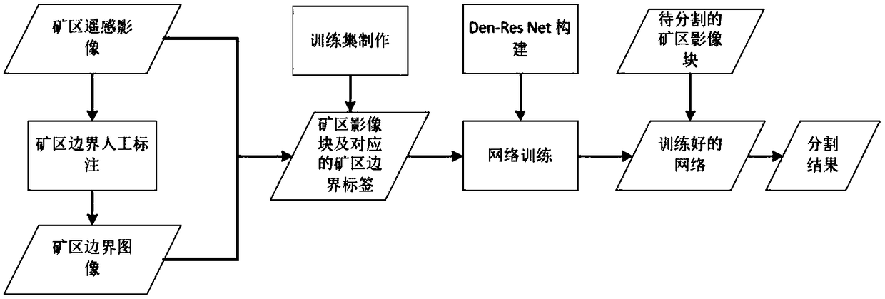
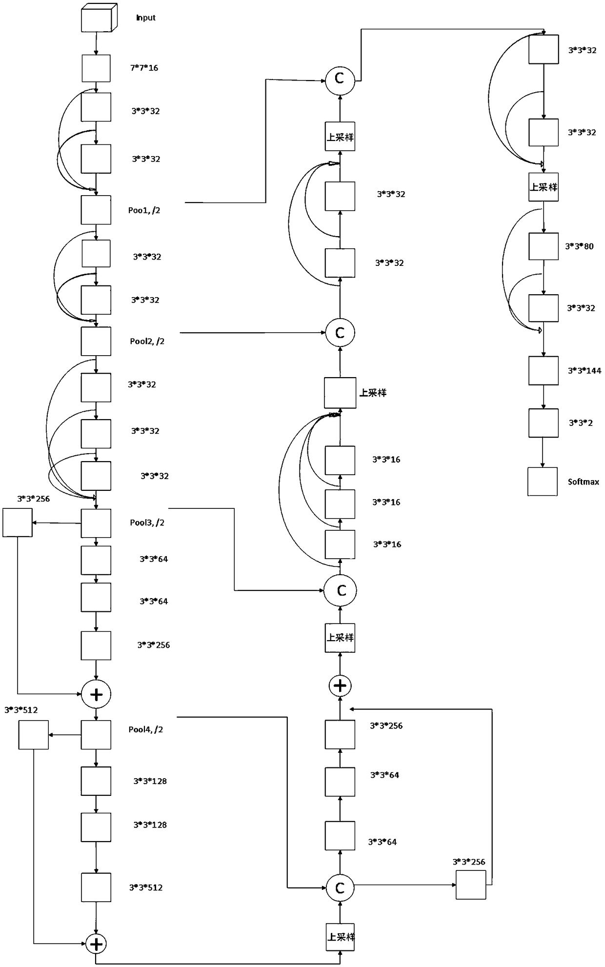
[0029] see Figure 1-3 , the present invention provides a technical solution: a method for automatic semantic segmentation of mining areas in remote sensing images, the specific steps are as follows:

[0030] Step 1. Create a training sample set

[0031] (1) Obtain the remote sensing image of the mining area, and manually draw the boundary of the mining area to form a boundary raster file;

[0032] (2) Use ArcGIS to generate fishing nets with two scales of 448*44...


PUM


Abstract

The invention discloses a mining area automatic semantic segmentation method in remote sensing image in the technical field of automatic target detection and depth learning, characterized in that: thespecific steps are as follows: 1, establishing a training sample set: acquisition of Remote Sensing Images of Mining Areas, and artificial delineating the boundaries of the mining area, forming a Boundary Grid File, 448*448 being generated by ArcGIS, 512*512 fishing nets of two scales, the remote sensing image of the mining area being cut in batches by using the two generated fishing nets to generate image blocks of different sizes as input data of the depth learning network, and the boundary files of the mining area grid in the image being cut through the fishing nets to generate boundary files corresponding to each mining area image block as label data of the network. The invention adopts a hybrid network Den-Res Net can abstract the extracted features while preserving the integrity offeatures, which can be used to solve the redundancy problem of Dense Net network, and the method has high efficiency, automatic semantic segregation and high accuracy.

Description

technical field [0001] The invention relates to the technical field of automatic target detection and deep learning, in particular to a method for automatic semantic segmentation of mining areas in remote sensing images. Background technique [0002] Semantic segmentation of mining area targets on multi-source and multi-temporal remote sensing images in a certain place can quickly and intuitively detect its temporal and spatial changes, which is conducive to analyzing the characteristics of temporal and spatial changes in mining areas, and can provide timely and objective information for the sustainable development of mineral resources. , accurate technical support and detailed scientific information, and also provide a scientific basis for the governance and transformation of mining cities and the planning and construction of "green cities". Therefore, the semantic segmentation of image mining target is of great significance. [0003] At present, there are mainly visual in...

Claims


Application Information

Patent Timeline
Patent Type & Authority Applications(China)
IPC IPC(8): G06K9/00G06K9/62
CPCG06V20/13G06F18/241G06F18/214
Inventor 吴艳兰杨辉殷志祥
Owner 合肥深蓝空间智能科技有限公司
Why Eureka
Try Eureka