
Optimal classification of land use and cover based on ELM for hyperspectral remote sensing images

A hyperspectral remote sensing and classification method technology, which is applied in the field of hyperspectral remote sensing image classification optimization, can solve problems such as ELM instability, low classification accuracy, and poor robustness, and achieve improved classification accuracy, improved classification accuracy, and improved generalization performance Effect

Inactive Publication Date: 2019-02-15
UNIV OF ELECTRONIC SCI & TECH OF CHINA
View PDF4 Cites 5 Cited by
  • Summary
  • Abstract
  • Description
  • Claims
  • Application Information

AI Technical Summary

Problems solved by technology

[0005] At present, the research results and data on the application of ELM to hyperspectral remote sensing image classification are not sufficient, so further research on it can enrich and verify the existing results, which is of great significance to the development of this field
In addition, although the hyperspectral remote sensing image classification method based on ELM has significant advantages in classification speed and efficiency, ELM itself has the disadvantages of instability and poor robustness, and due to the failure to fully exploit the richness of hyperspectral remote sensing images Problems such as the low classification accuracy brought by the information still need to be solved urgently.

Method used


Image

  • Optimal classification of land use and cover based on ELM for hyperspectral remote sensing images
  • Optimal classification of land use and cover based on ELM for hyperspectral remote sensing images
  • Optimal classification of land use and cover based on ELM for hyperspectral remote sensing images

Examples


Embodiment Construction

[0039] In order to make the purpose, technical solution and advantages of the present invention clearer, the present invention will be further described in detail below in conjunction with the implementation methods and accompanying drawings.

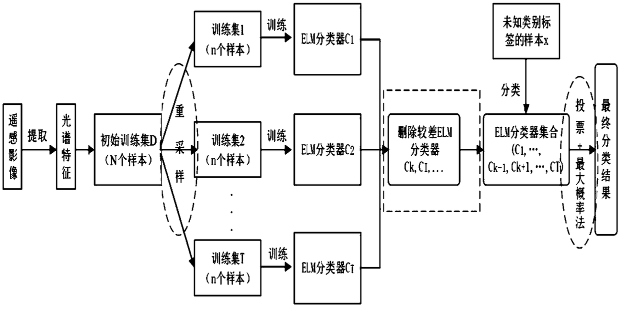
[0040] Based on the rich spectral features and spatial features of hyperspectral image data, using various cutting-edge technologies to improve and optimize the remote sensing image classification method based on the ELM algorithm to give full play to the advantages of the algorithm has become a research hotspot in the field of remote sensing. The research has very important theoretical and practical application value. Therefore, the present invention aims at the land classification method of hyperspectral remote sensing image based on ELM algorithm, makes full use of the rich spatial texture features of hyperspectral image, and optimizes it in combination with cutting-edge theories such as integrated learning and deep learning.

[0041...


PUM


Abstract

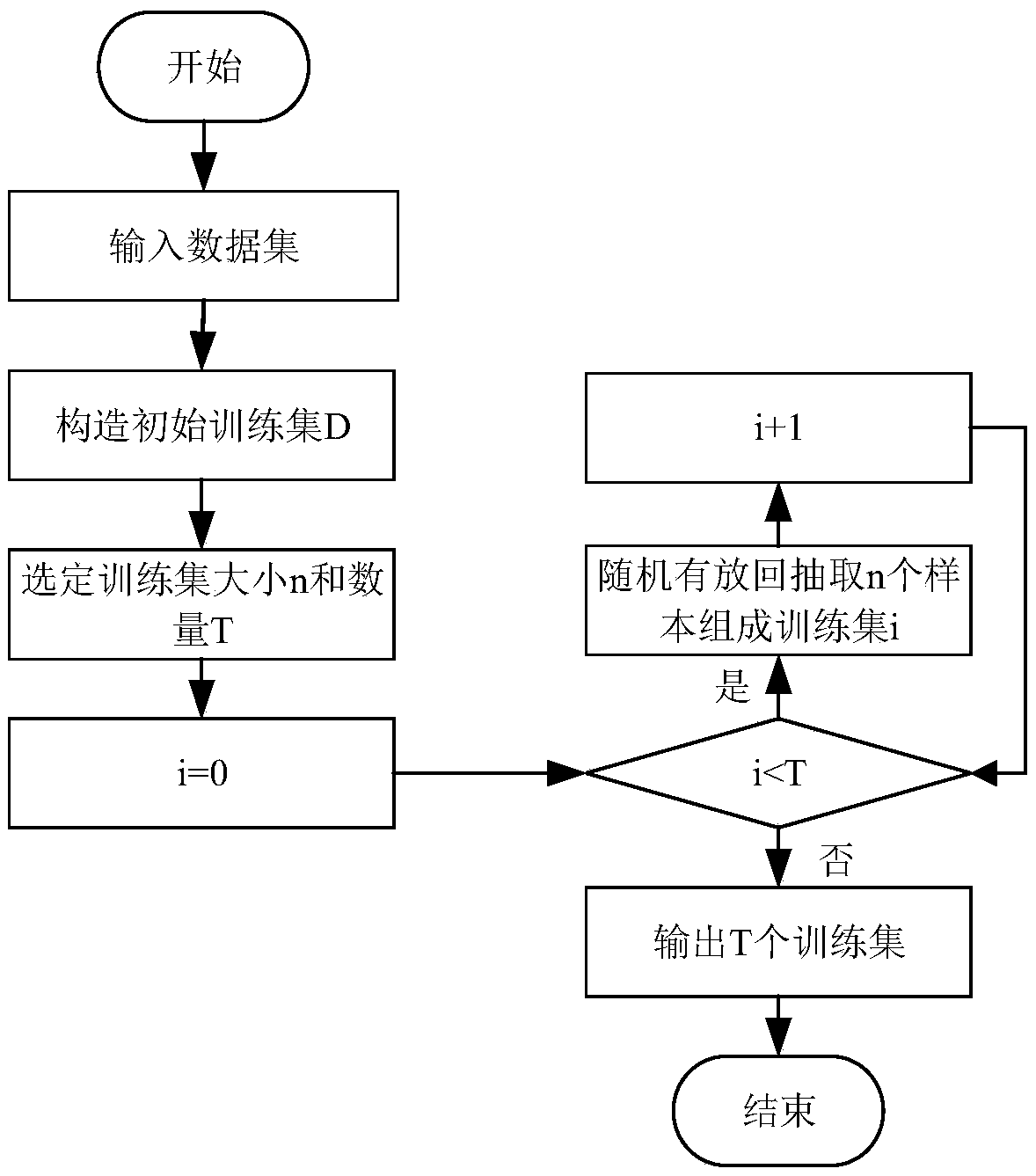
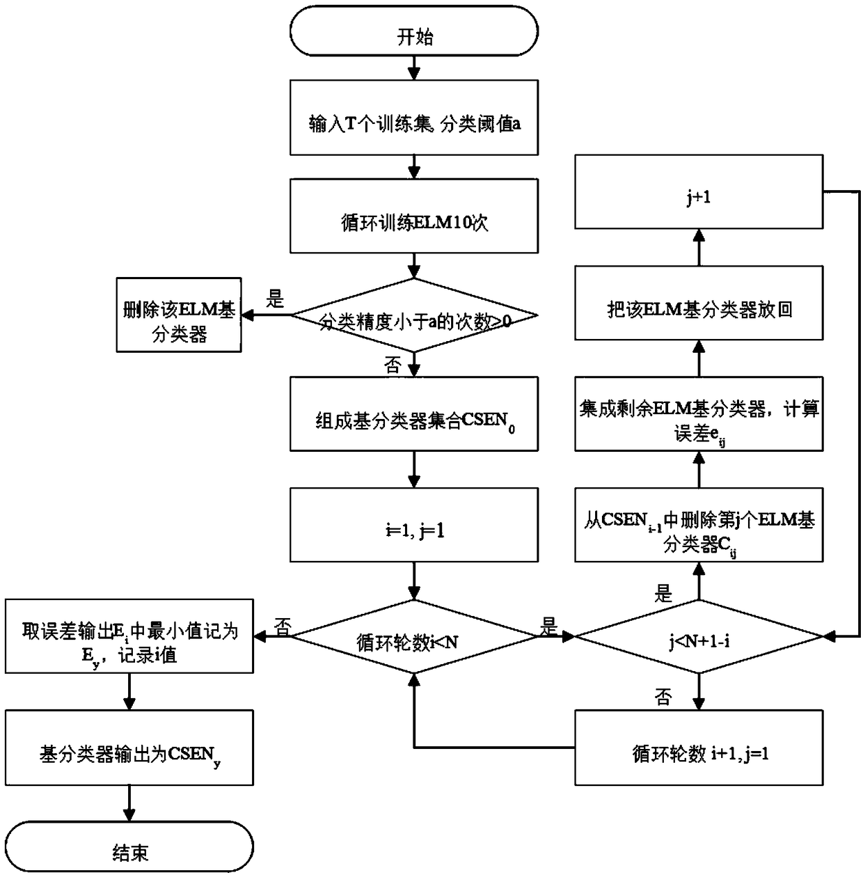
The invention discloses an ELM-based optimized classification method for land use and cover of hyperspectral remote sensing images, which comprises the following steps: firstly, a plurality of ELM-based classifiers are constructed, and a training data set is constructed for each ELM-based classifier; Then, T ELM-based classifiers are trained based on the training data sets of each ELM-based classifier, and the classification and prediction results of training samples in each training data set are obtained. Then, the ELM-based classifier set is pruned based on the classification prediction results. Finally, the hyperspectral remote sensing images to be classified, The spectral features of each pixel point are extracted, and the feature data of the object to be classified are obtained and inputted into the ELM-based classifiers in the set of classifiers retained after pruning, and the hyperspectral remote sensing images to be classified are classified and judged by ensemble, and the classification results of the hyperspectral remote sensing images to be classified are outputted. The invention realizes an optimized classification method for land use and cover of hyperspectral remote sensing images, which improves classification accuracy and classification processing efficiency.

Description

technical field [0001] The invention belongs to the technical field of spatial information, and in particular relates to a hyperspectral remote sensing image classification optimization method based on an extreme learning machine (Extreme Learning Machine, ELM). Background technique [0002] Hyperspectral image data contains rich information and has the advantages of multi-band, high resolution, adjacent broadband correlation and redundancy, so the ability to identify and finely classify ground objects is stronger than other remote sensing images. In view of the great advantages of hyperspectral imagery, land use cover classification using it has become a research hotspot in land use cover classification of remote sensing images. However, while promoting the rapid development and breakthrough of land use and cover classification, hyperspectral remote sensing images have also brought us some technical difficulties, mainly including the large amount of data brought by multi-ba...

Claims


Application Information

Patent Timeline
IPC IPC(8): G06K9/00G06K9/46G06K9/62
CPCG06V20/13G06V20/194G06V10/58G06V10/40G06F18/24G06F18/254G06F18/259G06F18/214
Inventor 黄方彭思远铁博陆俊杨浩陈胤杰
Owner UNIV OF ELECTRONIC SCI & TECH OF CHINA
Learn More