Shielding angle real-time resolving method and system based on digital map

A technology of digital map and shading angle, applied in the field of engineering application, can solve the problem of insufficient calculation accuracy, and achieve the effect of good application value

Active Publication Date: 2019-03-01
BEIJING INST OF ELECTRONICS SYST ENG
View PDF5 Cites 2 Cited by
  • Summary
  • Abstract
  • Description
  • Claims
  • Application Information

AI Technical Summary

Problems solved by technology

[0003] The purpose of the present invention is to provide a method and system for real-time calculation of shading angle based on digital maps, which can solve the problem that the calculation of the actual

Method used


Image

  • Shielding angle real-time resolving method and system based on digital map
  • Shielding angle real-time resolving method and system based on digital map
  • Shielding angle real-time resolving method and system based on digital map

Examples


Embodiment Construction

[0044] In order to illustrate the present invention more clearly, the present invention will be further described below in conjunction with preferred embodiments and accompanying drawings. Similar parts in the figures are denoted by the same reference numerals. Those skilled in the art should understand that the content specifically described below is illustrative rather than restrictive, and should not limit the protection scope of the present invention.

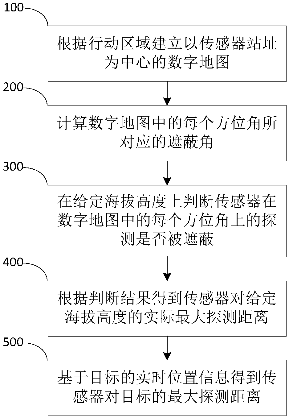
[0045] figure 1 It shows a real-time calculation method of shading angle based on a digital map proposed by an embodiment of the present invention, such as figure 1 As shown, the method includes the following steps:

[0046] S100. Establish a digital map centered on the sensor site according to the action area.

[0047] Specifically, S100 includes the following sub-steps:

[0048] S101. Transform the azimuth data of the action area into a geographic coordinate system.

[0049] S102. Convert the azimuth data converted i...


PUM


Abstract

The invention discloses a shielding angle real-time resolving method and system based on a digital map. The method comprises the following steps: establishing a digital map which takes a sensor site location as a center according to an action area; calculating shielding angles corresponding to different azimuth angles in the digital map; judging whether detection of sensors in every azimuth anglein the digital amp is shielded or not on the given height above sea level; acquiring the actual maximum detection distance of the sensors to the given height above sea level according to the judgmentresult; and acquiring the maximum detection distance of the sensor to a target on the basis of real-time position information of the target. The problems that calculation of the actual detection distance of the sensors at present is limited by the circumstance that terrain shielding data need to be measured in advance, calculation in real time by map data cannot be implemented, and the calculationprecision is not enough can be solved.

Description

technical field [0001] The invention relates to the field of engineering application technology, in particular to a method and system for real-time calculation of shading angles based on digital maps. Background technique [0002] At present, in engineering applications, the measured terrain shading data is mainly used to calculate the shading angle. This method is limited by the range of measurement data, lacks the ability to dynamically adjust, and cannot meet the needs of sensors for real-time shading calculations based on target positions. , pre-binding masked data makes the data accuracy constant, and cannot be flexibly customized according to usage requirements. Contents of the invention [0003] The purpose of the present invention is to provide a method and system for real-time calculation of shading angle based on digital maps, which can solve the problem that the calculation of the actual detection distance of the current sensor is limited by the prior measuremen...

Claims


Application Information

Patent Timeline
IPC IPC(8): G01C21/20G01C1/00
CPCG01C1/00G01C21/20
Inventor 亢京力黄骁飞王源源陈善松石磊张立栋
Owner BEIJING INST OF ELECTRONICS SYST ENG
Why Eureka
Try Eureka