Space planning conflict diagnosis method and system

A technology of spatial planning and diagnostic methods, applied in the fields of instruments, structured data retrieval, data processing applications, etc., can solve the problems of different spatial reference systems, conflicting plans, and complex data formats and formats.

Inactive Publication Date: 2019-05-31
辽宁省国土资源调查规划局
View PDF3 Cites 5 Cited by
  • Summary
  • Abstract
  • Description
  • Claims
  • Application Information

AI Technical Summary

Problems solved by technology

Due to the wide variety of data in the current planning and the wide range of data sources, there are differences in the statistical methods, data forms and management methods of various departments and units; the implementation standards of each plan are different; the data forms and formats are complicated; the spatial reference system of each department and unit Different plans lead to conflicts between multiple plans for the same land space, making it difficult to implement them uniformly

Method used


Image

  • Space planning conflict diagnosis method and system
  • Space planning conflict diagnosis method and system
  • Space planning conflict diagnosis method and system

Examples


Embodiment Construction

[0034] The following will clearly and completely describe the technical solutions in the embodiments of the present invention with reference to the accompanying drawings in the embodiments of the present invention. Obviously, the described embodiments are only some, not all, embodiments of the present invention. Based on the embodiments of the present invention, all other embodiments obtained by persons of ordinary skill in the art without making creative efforts belong to the protection scope of the present invention.

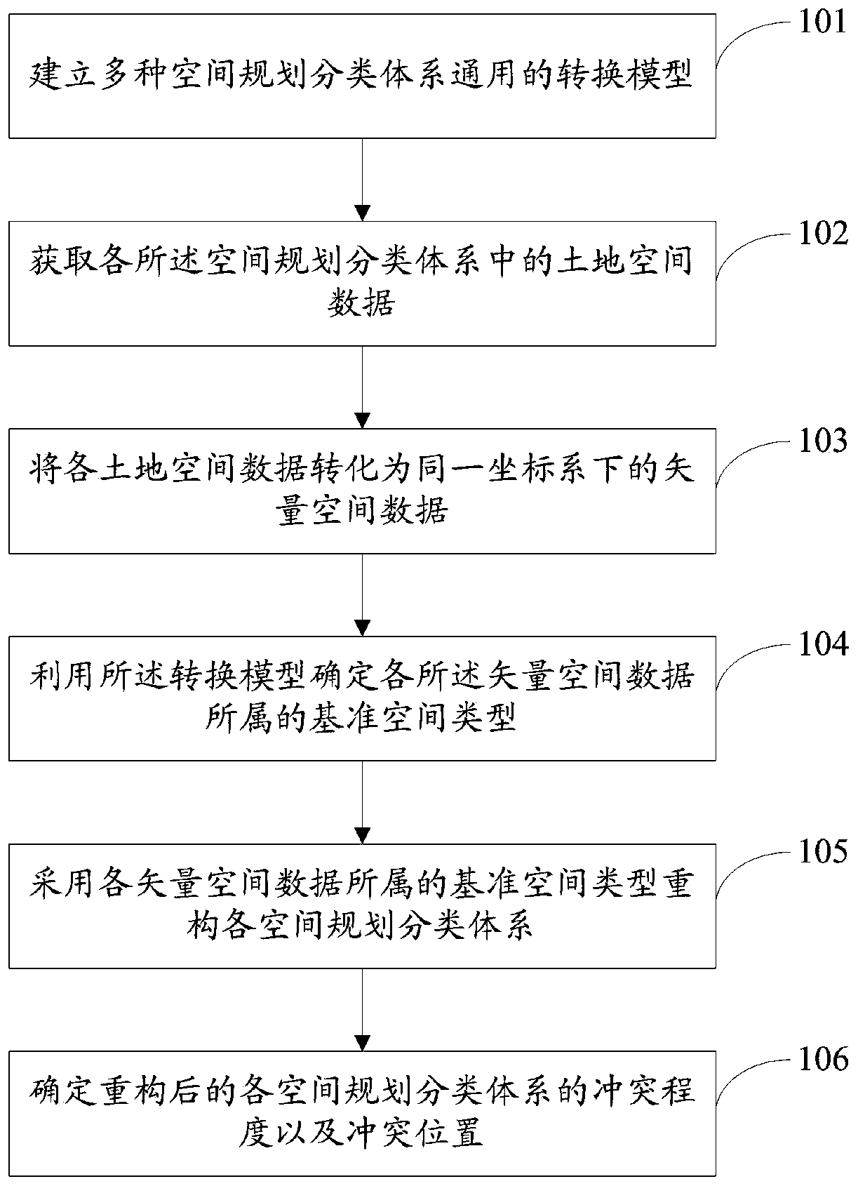
[0035] The object of the present invention is to provide a method and system for diagnosing conflicts in spatial planning, capable of diagnosing the location, degree and spatial type of conflicts, and providing a basis for the adjustment of spatial planning.

[0036] In order to make the above objects, features and advantages of the present invention more comprehensible, the present invention will be further described in detail below in conjunction with the acc...


PUM


Abstract

The invention discloses a space planning conflict diagnosis method and system. The method comprises the following steps of: establishing a universal conversion model of the multiple spatial planning classification systems, the conversion model comprising a corresponding relationship between land spatial types and reference spatial types in the spatial planning classification systems, and the reference spatial types comprising an agricultural production space, an industrial production space, a commercial production space, a living space, an ecological space and a guarantee space; obtaining landspace data in each space planning classification system; converting the land space data into vector space data under the same coordinate system; determining a reference space type to which each vector space data belongs by using a conversion model; reconstructing each space planning classification system by adopting the reference space type to which each vector space data belongs; and determininga conflict degree and a conflict position between the reconstructed spatial planning classification systems. The method can diagnose the position and degree of the conflict and the spatial type of the conflict, and provides a basis for the adjustment of the spatial planning.

Description

technical field [0001] The invention relates to the technical field of space planning, in particular to a method and system for diagnosing space planning conflicts. Background technique [0002] At present, the spatial planning system (land use planning, urban planning, ecological environment protection planning, development planning) of various cities in the country has contradictions and conflicts between various spatial planning. Including inconsistencies in levels: the four types of planning are divided into multiple levels, high-level planning guides low-level planning, coordinated and unified from top to bottom; inconsistency in deadlines: different planning deadlines are different, which is one of the main reasons for uncoordinated planning 1. Inconsistent results: Land use planning and urban planning involve many aspects, and each has its own focus. These problems lead to low allocation efficiency of space resources, such as the total amount of construction land sca...

Claims


Application Information

Patent Timeline
Patent Type & Authority Applications(China)
IPC IPC(8): G06F16/29G06Q50/26
Inventor 李洪兴边振兴崔伟王思琢石水莲闫雪松于淼王国申关鹏程雪峰陈丹杨忠臣彭兵根甄石
Owner 辽宁省国土资源调查规划局
Why Eureka
Try Eureka