Railway curve mapping method based on satellite positioning

A satellite positioning and railway technology, applied in satellite radio beacon positioning systems, measuring devices, electromagnetic measuring devices, etc., can solve the problems of inefficient and intelligent surveying and mapping, increasing the number of surveying and mapping points, and increasing errors, and achieve efficient and intelligent The effect of chemical surveying and mapping, high measurement accuracy and quantity reduction

Active Publication Date: 2019-06-14
株洲太昌电子信息技术股份有限公司
View PDF9 Cites 1 Cited by
  • Summary
  • Abstract
  • Description
  • Claims
  • Application Information

AI Technical Summary

Problems solved by technology

However, when surveying and mapping railway curves, the method of spacing dots and broken line fitting is adopted. The existing RTK measuring instruments on the market need to manually judge and select the points to be measured, and cannot automatically find the key measurement points. The conference leads to an increase in error, and the small spacing will increase the number of surveying points, and the surveying and mapping are not efficient and intelligent enough

Method used


Image

  • Railway curve mapping method based on satellite positioning
  • Railway curve mapping method based on satellite positioning
  • Railway curve mapping method based on satellite positioning

Examples


Embodiment Construction

[0035] The present invention will be described in detail below in conjunction with the accompanying drawings. The description in this part is only exemplary and explanatory, and should not have any limiting effect on the protection scope of the present invention. In addition, those skilled in the art can make corresponding combinations of features in the embodiments in this document and in different embodiments according to the descriptions in this document.

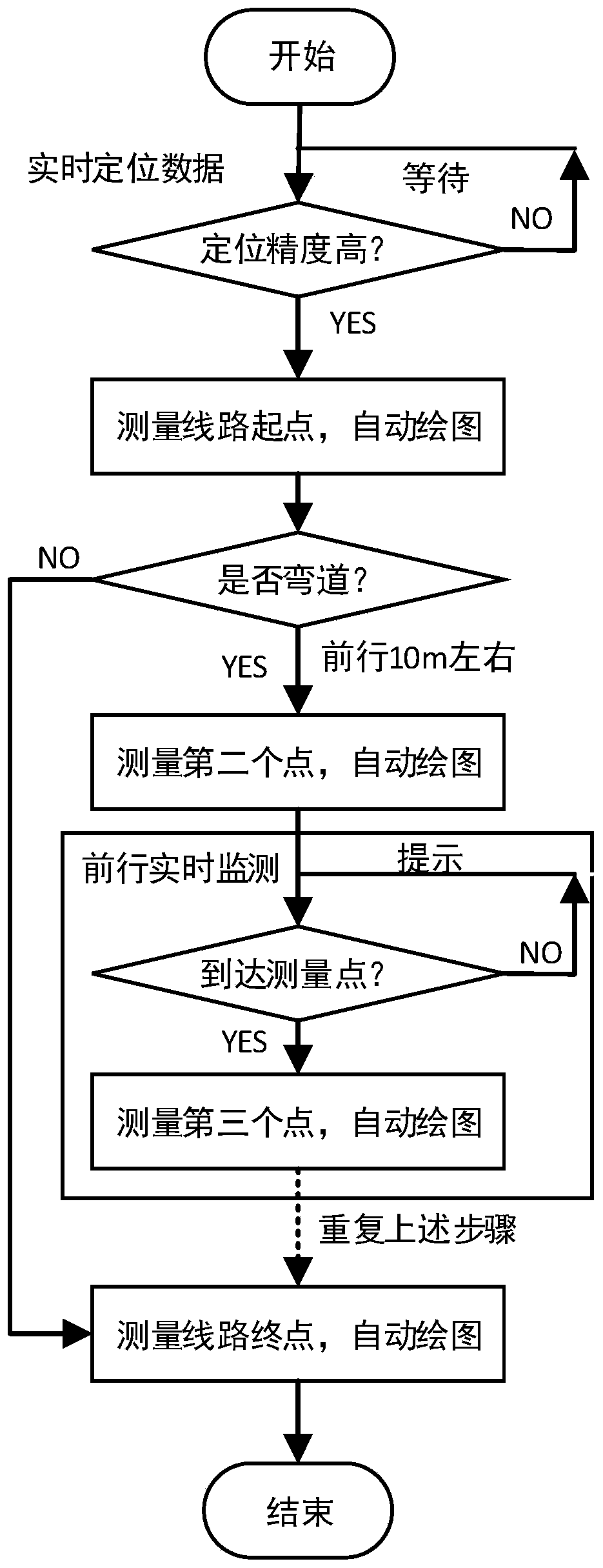
[0036] A method for surveying and mapping railway curves based on satellite positioning, such as figure 1 , including the following steps:

[0037] (1) Determination of the reference line: real-time positioning, determine the measurement starting point, start automatic drawing, select a reference point on the railway with a predetermined distance from the measurement starting point, and use the connection line between the measurement starting point and the reference point as the reference line;

[0038] (2) Determine th...


PUM


Abstract

The invention relates to a railway curve mapping method based on satellite positioning. The railway curve mapping method based on the satellite positioning comprises the following steps that (1) a reference line is determined, specifically, a measuring starting point is determined, a datum point in a pre-set distance away from the measuring starting point on a railway is determined, and the connecting line of the measuring starting point and the datum point is taken as a reference line; (2) a first key mapping point is determined, specifically, the included angle of the connecting line of thecurrent position and the datum point and the reference line and the distance of the connecting line are calculated in real time, when the included angle and the distance of the connecting line of thecurrent position and the datum point reach the pre-set condition, the first key mapping point is reached according to prompts, mapping of the first key mapping point is completed, the mapping circuitdiagram is automatically refreshed, and the connecting line of the first key mapping point and the datum point is set to be a first reference connecting line; (3) a second key mapping point is found out to map; (4) the step (3) is repeated until a mapping destination is reached; and (5) the overall length of the railway curve is calculated. According to the railway curve mapping method based on satellite positioning, key mapping points can be automatically found out, the quantity of the measuring points in a controllable error is reduced, and the measuring precision is high.

Description

technical field [0001] The invention belongs to the technical field of railway surveying and mapping, and in particular relates to a method for surveying and mapping railway curves based on satellite positioning. Background technique [0002] In order to ensure the safe operation of the train, it is necessary to use satellite positioning technology to accurately survey and map the key positions and key sections of the railway. At present, RTK surveying instrument is a kind of more commonly used surveying and mapping equipment. However, when surveying and mapping railway curves, the method of spacing dots and broken line fitting is adopted. The existing RTK measuring instruments on the market need to manually judge and select the points to be measured, and cannot automatically find the key measurement points. The conference leads to an increase in error, and the small spacing will increase the number of surveying points, and the surveying and mapping are not efficient and in...

Claims


Application Information

Patent Timeline
Patent Type & Authority Applications(China)
IPC IPC(8): G01B7/28G01S19/50
Inventor 刘汉岭李挺何志国
Owner 株洲太昌电子信息技术股份有限公司
Why Eureka
Try Eureka