Overseas power line selection method based on multi-source satellite remote sensing image joint adjustment
A satellite remote sensing image and joint adjustment technology, which is applied in graphic image conversion, image data processing, data processing applications, etc., can solve the problems that multi-source satellite remote sensing images cannot meet the accuracy and the regional network adjustment error is large
- Summary
- Abstract
- Description
- Claims
- Application Information
AI Technical Summary
Problems solved by technology
Method used
Image


Examples
Embodiment 1
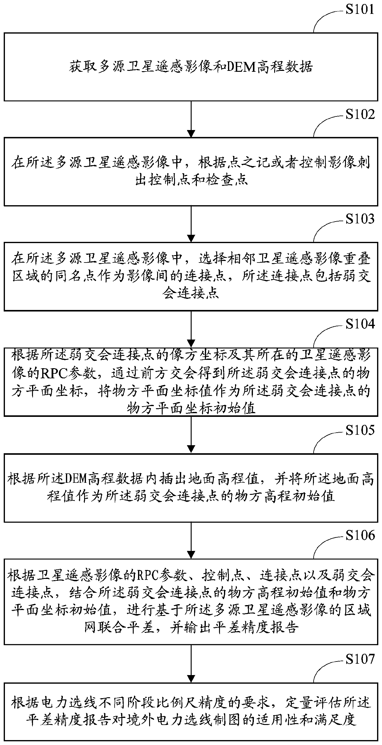
[0056] like figure 1 As shown, the embodiment of the present invention provides a method for overseas power line selection, which is used to reduce the error of multi-source satellite remote sensing images, so that the multi-source remote sensing images meet the accuracy conditions for overseas power line selection. The steps of the overseas power line selection method include:
[0057] S1. Obtain multi-source satellite remote sensing images and DEM elevation data.
[0058] In one embodiment, the multi-source satellite remote sensing images include stereoscopic mapping satellite remote sensing images and high-resolution satellite remote sensing images.
[0059] In one embodiment, the DEM elevation data includes GDEM data and SRTM data; both the GDEM data and SRTM data have preset projection modes and banding modes.
[0060] In specific applications, multi-source satellite remote sensing images are based on stereoscopic mapping satellite remote sensing images or high-resolutio...
Embodiment 2
[0085] In one embodiment, in the above step S6, according to the RPC parameters, control points, connection points and weak intersection connection points of the satellite remote sensing image, combined with the initial value of the object-space elevation and the initial value of the object-space plane coordinates of the weak intersection connection point, The implementation process of performing the regional network joint adjustment based on the multi-source satellite remote sensing image and outputting the adjustment accuracy report may include:
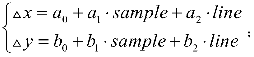
[0086] 1. According to the rational function model RFM and the image square affine transformation model, list the error equation of the planar block adjustment and construct the normal equation, use the least square method to solve the normal equation, and obtain the least square solution of the correction value of the imaging model correction parameters, residuals for each error equation, and then update the corrected parameters fo...
Embodiment 3
[0116] The embodiment of the present invention illustrates the application of the block network adjustment algorithm with actual cases. The basic process is:
[0117] Firstly, obtain the scale accuracy requirements at different stages of power line selection, and then use the overseas power line selection method based on the joint adjustment of multi-source satellite remote sensing images in Embodiment 1 to combine the multi-source satellite remote sensing image area network in the power line selection drawing. Quantitative evaluation of the applicability and satisfaction of adjustment accuracy.
[0118] In a specific application, the above evaluation process can specifically be as follows: After obtaining the plane accuracy and elevation accuracy of the joint adjustment of the multi-source satellite remote sensing image area network, according to the national standard of the People's Republic of China "Specifications for Aerial Triangulation of Digital Aerial Photogrammetry" ...
PUM
 Abstract
Description
Claims
Application Information
 - R&D Engineer
- R&D Manager
- IP Professional
- Industry Leading Data Capabilities
- Powerful AI technology
- Patent DNA Extraction
Browse by: Latest US Patents, China's latest patents, Technical Efficacy Thesaurus, Application Domain, Technology Topic.
© 2024 PatSnap. All rights reserved.Legal|Privacy policy|Modern Slavery Act Transparency Statement|Sitemap