Map service method with time and resolution dimensions

A service method and map server technology, applied in geographic information databases, special data processing applications, structured data retrieval, etc., can solve the problem that a single image tile map service cannot directly express multi-resolution temporal image information, tiles The pyramid structure does not consider issues such as multi-resolution and temporal information at the same time

Inactive Publication Date: 2019-07-23
中科遥感(深圳)卫星应用创新研究院有限公司 +2
View PDF0 Cites 0 Cited by
  • Summary
  • Abstract
  • Description
  • Claims
  • Application Information

AI Technical Summary

Problems solved by technology

[0003] The purpose of the present invention is to overcome the single tile pyramid structure of the image tile map service in the prior art without considering the information of multi-resolution and time dimension at the same time, so the single image tile map service cannot directly express the multi-resolution temporal image The shortcoming of information is proposed, and its purpose is to provide a map service method with time and resolution dimensions

Method used


Image

  • Map service method with time and resolution dimensions
  • Map service method with time and resolution dimensions
  • Map service method with time and resolution dimensions

Examples


Embodiment Construction

[0023] A map service method with time and resolution dimensions of the present invention will be described in detail below in conjunction with the drawings and embodiments of the description:

[0024] A map service method with time and resolution dimensions, the steps of which include:

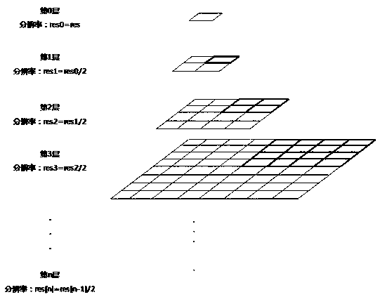
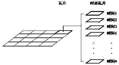
[0025] (i) On the server side, generate tiles from data sources (such as images) according to the temporal tile pyramid structure corresponding to the resolution dimension;

[0026] (ii) Store tile resolution dimensions and temporal information in the database while producing tiles;

[0027] (iii) Publish tile resources as tile map services (such as standard tile services such as WMS-C, WMTS, TMS, and XYZ) through map servers that support resolution dimensions and temporal information;

[0028] (iv) The client can obtain specific resolution dimensions or time information by querying the database or select a resolution dimension according to business freedom requirements, and a time point or a...


PUM


Abstract

The invention discloses a map service method with time and resolution dimensions. The map service method comprises the following steps: (i) producing a tile from a data source at a server side according to a temporal tile pyramid structure corresponding to the resolution dimensions; ii) storing the tile resolution dimension and the temporal information in a database; iii) enabling the map server to issue the tile resource as a tile map service; (iv) selecting a resolution dimension, and determining a temporal information parameter; (v) enabling the client to obtain a tile resource access temporal tile map service; and (vi) enabling the map server to query the temporal tile pyramid resource to obtain a tile and return the tile to the client. According to the method, different temporal tiledata is accessed in a single tile map service, and temporal information is directly expressed; data with different resolution dimensions can exist in the same tense; tile data matched with a time period under a certain resolution dimension and the tile data closest to a time point are acquired, and the tile data of the time point are accurately matched.

Description

technical field [0001] The invention belongs to the field of map services, in particular to a map service method with time and resolution dimensions. Background technique [0002] The image tile map service uses a tile pyramid structure to organize tile data, and the single tile pyramid structure does not consider the information of multi-resolution and time dimensions at the same time, so a single image tile map service cannot directly express multi-resolution temporal Image information. Contents of the invention [0003] The purpose of the present invention is to overcome the single tile pyramid structure of the image tile map service in the prior art without considering the information of multi-resolution and time dimension at the same time, so the single image tile map service cannot directly express the multi-resolution temporal image The purpose of this paper is to provide a map service method with time and resolution dimensions. [0004] Technical scheme of the pr...

Claims


Application Information

Patent Timeline
Patent Type & Authority Applications(China)
IPC IPC(8): G06F16/29
CPCG06F16/29
Inventor 李文东李涛檀飞腾
Owner 中科遥感(深圳)卫星应用创新研究院有限公司
Why Eureka
Try Eureka