Road network subarea division and evaluation method based on Canopy + Kmeans clustering

A kmeans clustering and road network technology, applied in the field of neural networks, can solve problems such as the result is not the optimal solution, different clustering results, and the K value is difficult to estimate.

Pending Publication Date: 2019-09-13
GUANGDONG COMM POLYTECHNIC
View PDF6 Cites 18 Cited by
  • Summary
  • Abstract
  • Description
  • Claims
  • Application Information

AI Technical Summary

Problems solved by technology

Among them, Wang Xiaoxuan (2017) proposed a road network partition method based on Kmeans clustering, but the K value of this method is preset, and the K value is generally difficult to estimate and does not h

Method used


Image

  • Road network subarea division and evaluation method based on Canopy + Kmeans clustering
  • Road network subarea division and evaluation method based on Canopy + Kmeans clustering
  • Road network subarea division and evaluation method based on Canopy + Kmeans clustering

Examples


Embodiment

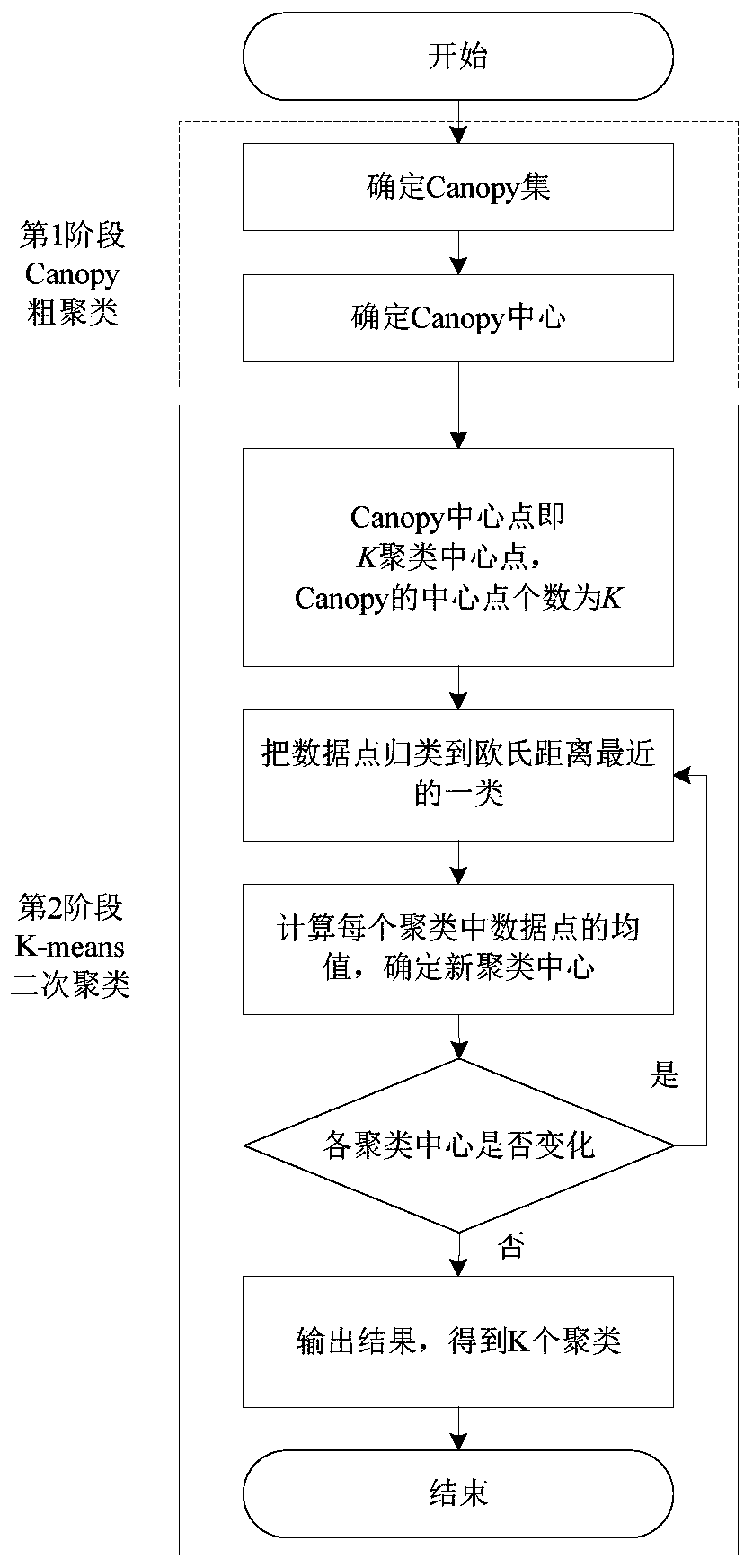
[0081] Such as Figures 1 to 20 Shown is an embodiment of the road network sub-area division and its evaluation method based on Canopy+Kmeans clustering in the present invention. The road network sub-area division method uses real-time collection of road section center latitude and longitude, road section average speed, road section average density, etc. as samples data, the specific steps are as follows:

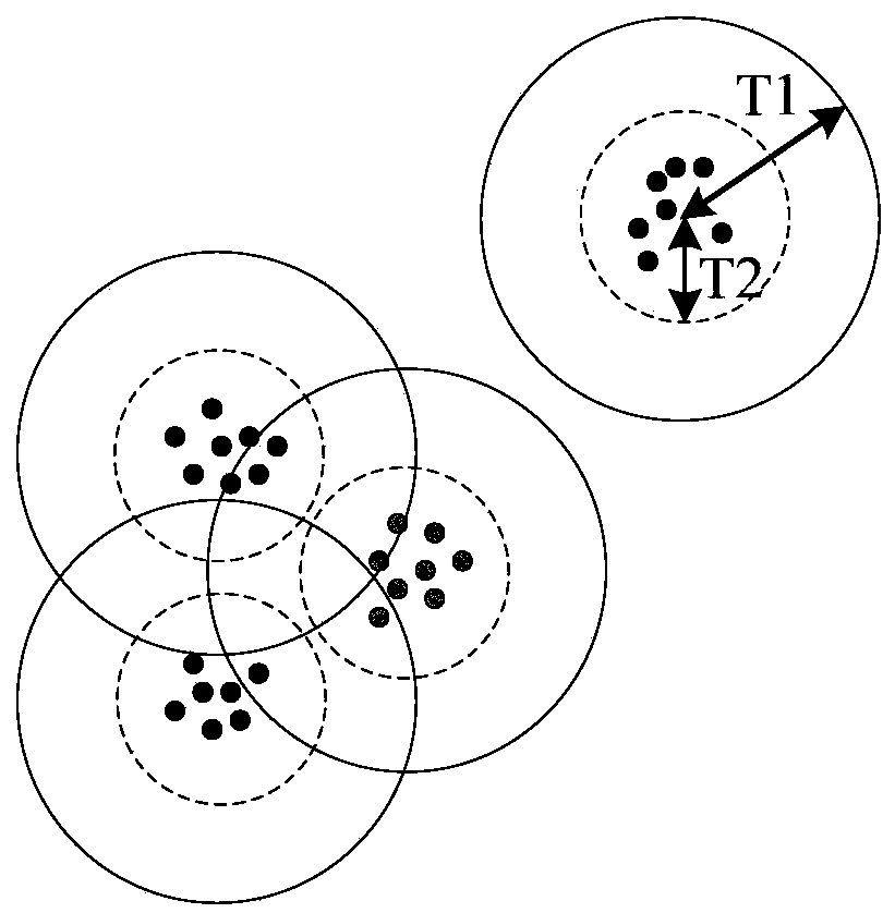
[0082] (1) Perform data preprocessing; use the Canopy algorithm based on the "minimum-maximum principle" to determine several Canopy and Canopy center points;

[0083] (2) After step (1), carry out the secondary clustering of Kmeans; Canopy central point in the collection step (1), the central point number of Canopy is the K value of Kmeans algorithm;

[0084] (3) After step (2), calculate the Euclidean distances from each data point to K cluster center points respectively, and divide it into the cluster with the smallest distance to form a new cluster;

[0085] (4) After...


PUM


Abstract

The invention relates to the field of neural network technical methods, in particular to a road network sub-region division and evaluation method based on Canopy + Kmeans clustering, which takes real-time acquisition of road section center latitude and longitude, road section average speed and road section average density as sample data, and comprises the following specific steps: (1) carrying outdata preprocessing; determining a plurality of Canopy and Canopy center points by adopting a Canopy algorithm based on the minimum and maximum principle; (2) after the step (1), carrying out Kmeans secondary clustering; collecting Canopy center points in the step (1), wherein the number of the Canopy center points is the K value of the Kmeans algorithm; and (3) after the step (2), respectively calculating Euclidean distances from each data point to K clustering center points, and dividing the Euclidean distances into a cluster with the minimum distance to form a new cluster. The road networksubarea division method based on a Canopy-Kmeans clustering algorithm is provided by taking road section center longitude and latitude, road section average speed and road section average density which are acquired in real time as sample data, so that the defects of the Kmeans algorithm are overcome.

Description

technical field [0001] The present invention relates to the field of neural network technology and methods, and more specifically, to a road network subdivision and evaluation method based on Canopy+Kmeans clustering. Background technique [0002] With the increasing size of cities, factors such as uneven distribution of road network congestion, and various types of roads, the urban road network is heterogeneous, which is not conducive to urban traffic management and control. Therefore, it is necessary to subdivide the urban road network Division. The division of road network sub-regions can be regarded as the process of dividing and clustering road segments with similar attributes, so a clustering algorithm can be used to divide road network sub-regions. Clustering is to divide the data set into several clusters (classes) with similar attributes and characteristics. The attributes or characteristics of objects in the same cluster are similar to each other, and are quite di...

Claims


Application Information

Patent Timeline
IPC IPC(8): G06K9/62G08G1/01
CPCG08G1/01G06F18/2321G06F18/23213
Inventor 林晓辉曹成涛廖建尚李少伟
Owner GUANGDONG COMM POLYTECHNIC
Why Eureka
Try Eureka