
Map construction method, and navigation method and device

A technology for map construction and navigation points, which is applied in the fields of artificial intelligence and computer vision, and can solve problems such as difficulty in building high-precision maps.

Active Publication Date: 2019-10-25
BEIJING JINGDONG SHANGKE INFORMATION TECH CO LTD +1
View PDF6 Cites 6 Cited by
  • Summary
  • Abstract
  • Description
  • Claims
  • Application Information

AI Technical Summary

Problems solved by technology

However, under the conditions of few features and large scene scale, it is difficult to construct high-precision maps using existing SLAM algorithms

Method used


Image

  • Map construction method, and navigation method and device
  • Map construction method, and navigation method and device
  • Map construction method, and navigation method and device

Examples


Embodiment Construction

[0039] The application will be further described in detail below in conjunction with the accompanying drawings and embodiments. It should be understood that the specific embodiments described here are only used to explain related inventions, rather than to limit the invention. It should also be noted that, for the convenience of description, only the parts related to the related invention are shown in the drawings.

[0040] It should be noted that, in the case of no conflict, the embodiments in the present application and the features in the embodiments can be combined with each other. The present application will be described in detail below with reference to the accompanying drawings and embodiments.

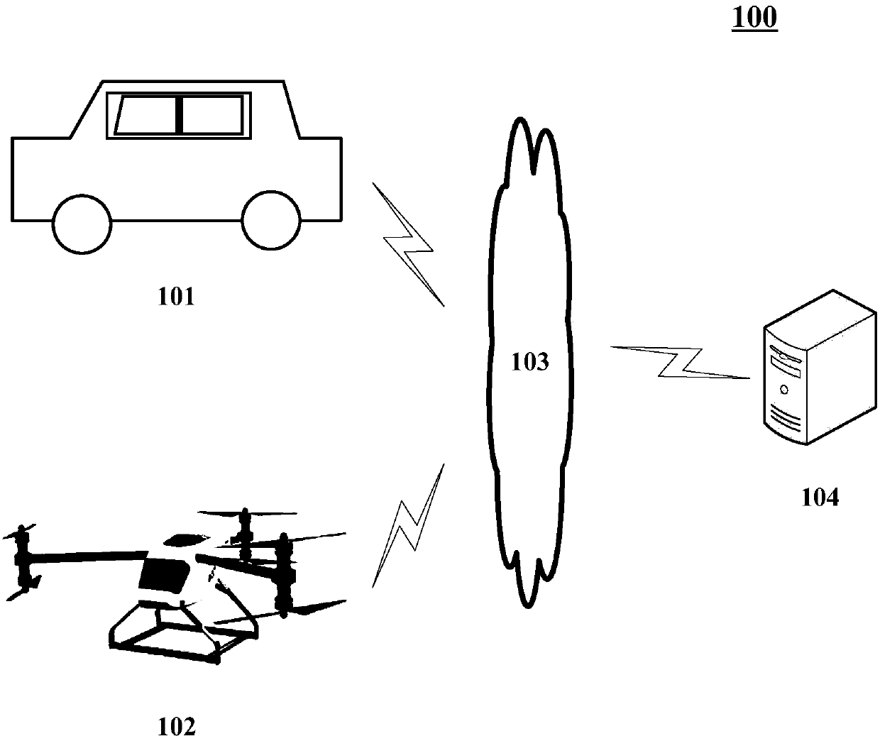
[0041] figure 1 An exemplary system architecture 100 to which embodiments of the map construction method, navigation method, map construction device or navigation device of the present application can be applied is shown.

[0042] Such as figure 1 As shown, the system arch...


PUM


Abstract

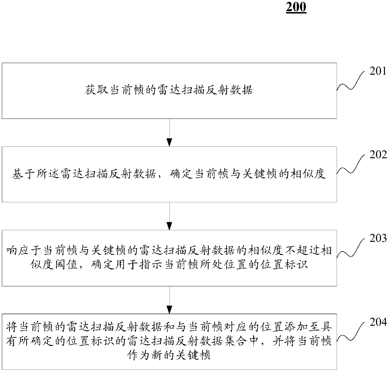
The embodiment of the application discloses a map construction method, and a navigation method and device. An embodiment of the map construction method comprises the following steps: acquiring radar scanning reflection data of a current frame; determining similarity of the current frame and a key frame based on the radar scanning reflection data; in response to a condition that the similarity of the radar scanning reflection data of the current frame and the key frame does not exceed a similarity threshold, determining a location identifier for indicating the location of the current frame; andadding the radar scanning reflection data of the current frame and the location corresponding to the current frame to a radar scanning reflection data set with the determined location identifier, andregarding the current frame as the new key frame. By continuously collecting the radar scanning reflection data, the amount of the radar scanning reflection data under various location identifiers can be updated and enriched, so that the environment representative element can be continuously updated and enriched.

Description

technical field [0001] The embodiments of the present application relate to the field of artificial intelligence, specifically to the field of computer vision, and in particular to a map construction method, a navigation method and a device. Background technique [0002] In order to realize the delivery service in remote areas, in the prior art, logistics drones can usually be used to deliver items. [0003] The flight environment of logistics drones has the characteristics of few features and large scene scale. Fewer features means that the scene in the working environment is relatively single, and there are fewer features in the environmental image; and the large scale of the scene makes the sensing range of the sensors on the logistics drone relatively limited compared to its working environment. [0004] In the existing logistics UAV positioning and navigation scheme, in addition to using GPS inertial integrated navigation, SLAM (Simultaneous Localization and Mapping, r...

Claims


Application Information

Patent Timeline
Patent Type & Authority Applications(China)
IPC IPC(8): G01S17/89G01S17/93G01C21/32G01C21/34
CPCG01S17/89G01S17/933G01C21/32G01C21/343G01C21/3446G01S17/931
Inventor 门春雷刘艳光张文凯陈明轩郝尚荣郑行徐进韩微
Owner BEIJING JINGDONG SHANGKE INFORMATION TECH CO LTD
Learn More