

Landsat remote sensing data-based multi-cloud rain and fog region rice identification method
A technology of remote sensing data and identification method, applied in the field of agricultural remote sensing, can solve the problems of low extraction accuracy of planting area and failure to reflect the planting situation, and achieve the effect of accurate rice planting area
Active Publication Date: 2019-11-19
UNIV OF ELECTRONICS SCI & TECH OF CHINA
View PDF7 Cites 30 Cited by
- Summary
- Abstract
- Description
- Claims
- Application Information
AI Technical Summary
Problems solved by technology
[0005] Aiming at the problem that the extraction accuracy of the existing rice planting area is low and cannot reflect the actual planting situation, the present invention provides a rice identification method based on long-term sequence Landsat remote sensing data in cloudy, rainy and foggy areas, using Zhe Zhu's CCDC algorithm and time series model to Simulate and predict the Landsat albedo data without clouds and strips at any time, and use the rice cultivation system and agricultural calendar as an aid to gradually extract the rice planting area in the remote sensing image, achieving the purpose of improving the extraction accuracy
Method used
View moreImage
Smart ImageViewing Examples

Examples
Embodiment
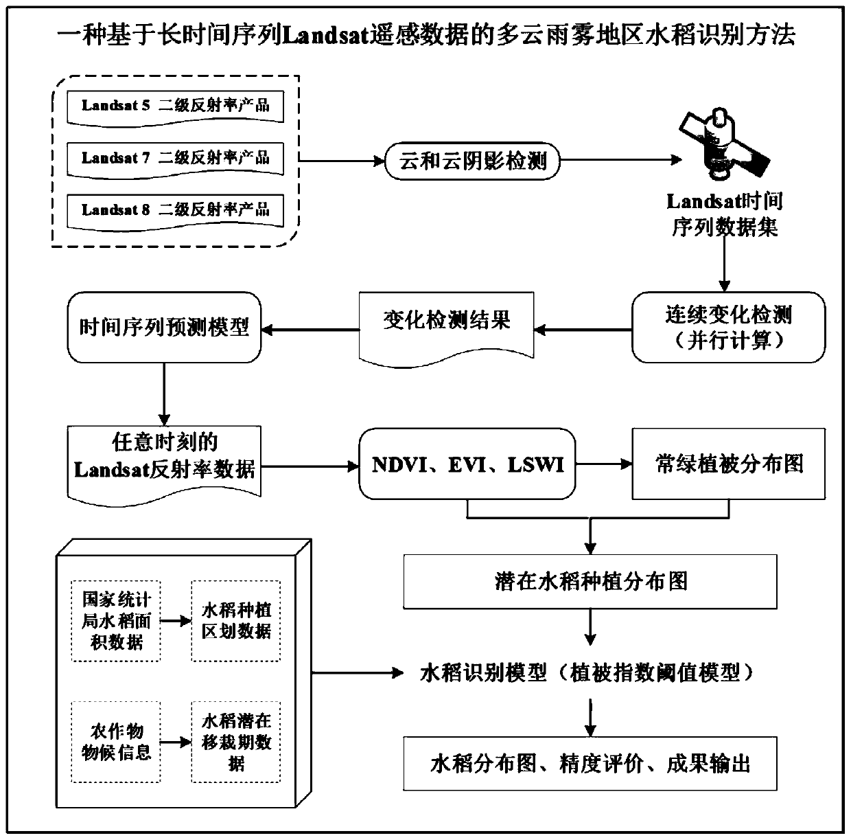
[0049] A method for identifying rice in cloudy, rainy and foggy areas based on long-term Landsat remote sensing data, comprising the following steps:
[0050] Step 1: Data Acquisition:
[0051] According to the remote sensing satellite albedo products provided by the United States Geological Survey (USGS), obtain Landsat 5 / 7 / 8 secondary albedo products; For the crop phenology information in each region, the rice planting regionalization data and the rice potential transplanting period data are obtained; based on the ground measurement data, the LSWI and EVI (NDVI) data of the rice irrigation and transplanting period are obtained.
Login to View More PUM
 Abstract
The invention belongs to the technical field of agricultural remote sensing, and particularly relates to a Landsat remote sensing data-based multi-cloud rain and fog region rice identification method.The method includes: distinguishing rice from other obvious ground objects, and obtaining a potential rice planting area in a remote sensing image; based on ground measured data, extracting the relationship between the spectral indexes of the rice sample pixel data in the transplanting stage; establishing a vegetation index threshold value model for rice identification by combining rice plantingregion division data and rice potential transplanting period data, extracting rice planting areas in remote sensing images step by step in a segmented mode, combining the planting areas of different rice types, and obtaining a final rice planting region distribution diagram rapidly and accurately. Compared with an existing method for extracting the rice planting area through a remote sensing technology, the method is mainly suitable for southwest China regions with cloudy rain and fog. According to the invention, the actual planting condition can be truly reflected, and the planting area extraction precision is improved.
Description
technical field [0001] The invention belongs to the technical field of agricultural remote sensing, and in particular relates to a method for identifying rice in cloudy, rainy and foggy areas based on Landsat remote sensing data. Background technique [0002] As one of the three major food crops in the world, rice is the most important source of food for human beings, and occupies a very important position in the food production structure of our country and the world. Rice is the staple food of more than half of the world's population, especially for developing countries in Asia, Africa and Latin America, where safe production of food is particularly important. The production status of rice is closely related to the food security and social stability of the whole world. Mastering the information on rice planting area, growth and yield can provide important information for monitoring China's rice production status, guiding agricultural production and macro-regulation of rice...
Claims
Login to View More Application Information
Patent Timeline
 Patent Type & AuthorityApplications(China)
IPC IPC(8): G06F17/10G06T7/62G01N21/17G01N21/55
CPCG06F17/10G01N21/17G01N21/55G01N2021/1793Y02A90/10
Inventor何彬彬冯实磊张宏国
OwnerUNIV OF ELECTRONICS SCI & TECH OF CHINA