Grid system and method based on address geographic position

A geographic location and grid system technology, applied in the field of geographic information, can solve the problems of low security, traceability and authenticity

Pending Publication Date: 2020-03-17
BEIJING HONGDA KEMEI TECH
View PDF0 Cites 0 Cited by
  • Summary
  • Abstract
  • Description
  • Claims
  • Application Information

AI Technical Summary

Problems solved by technology

[0005] The purpose of the present invention is to provide a grid system and method based on address and geograph

Method used


Image

  • Grid system and method based on address geographic position
  • Grid system and method based on address geographic position
  • Grid system and method based on address geographic position

Examples


Embodiment 1

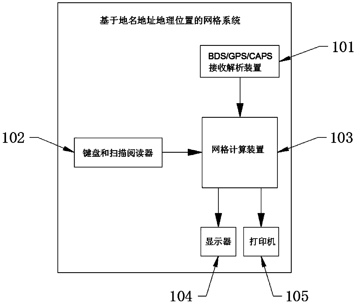
[0040] This embodiment 1 provides a grid system and method based on address geographic location, the structural diagram of the system can be found in figure 1 , figure 1 Among them, the system includes a BDS / GPS / CAPS (BeiDou / GPS / CAPS Cape) receiving analysis device 101, a keyboard and a scanning reader 102, a grid computing device 103, a display screen 104 and a printer 105, wherein:

[0041] The BDS / GPS / CAPS receiving and analyzing device 101 is arranged in an open space outside the grid computing device 103; the keyboard and scanning reader 102, the display screen 104 and the printer 105 are all arranged in the grid The grid computing device 103 is external.

[0042] The BDS / GPS / CAPS receiving and analyzing device 101 , the keyboard and scanning reader 102 , the display screen 104 and the printer 105 are connected to the grid computing device 103 .

[0043] The BDS / GPS / CAPS receiving and analyzing device 101 is used to receive the satellite navigation signal of the designa...


PUM


Abstract

The invention discloses a grid system and method based on an address geographic position. The grid system comprises a BDS/GPS/CAPS receiving and analyzing device, a keyboard, a scanning reader, a gridcomputing device, a display screen and a printer; the BDS/GPS/CAPS receiving and analyzing device is used for receiving and analyzing geographic position longitude and latitude information, which isaccurate to meter level, of a certain appointed point; the keyboard is used for inputting accurate geographic position longitude and latitude information of a certain designated point, or inputting ageographic position name and analyzing the geographic position name into accurate geographic position longitude and latitude information; the grid computing device is used for converting an accurate geographic position of a specified point into a unique grid code of the specified point, the grid codes are 25-bit codes formed by mixing English letters and numbers, the first 20 bits of the grid codes uniquely map a geographic grid of 1 m < 2 > at a longitude and latitude position of a certain specified point, the last nine bits of the grid codes represent 999, 999 and 999 sequential code addresses possessed by the grid of the table, the display screen displays the grid codes, and the printer prints a grid certificate.

Description

technical field [0001] The invention relates to the technical field of geographic information, in particular to a grid system and method based on address and geographic location. Background technique [0002] Existing network technology adopts virtual space. [0003] However, the network virtual space brings problems such as false information, untraceable information, and disconnection with the actual geographical space, resulting in low security, traceability, and authenticity of the virtual network space. [0004] Based on this, the present invention designs a grid system and method based on address and geographic location to solve the above-mentioned problems. Contents of the invention [0005] The purpose of the present invention is to provide a grid system and method based on address and geographic location to solve the problems of low security, traceability and authenticity in the existing network technology. [0006] In order to achieve the above object, the prese...

Claims


Application Information

Patent Timeline
IPC IPC(8): G06F16/29
CPCG06F16/29
Inventor 方宏一
Owner BEIJING HONGDA KEMEI TECH
Why Eureka
Try Eureka