Urban information model modeling method based on space-time grid data

A city information and model modeling technology, applied in the information field, can solve problems such as the internal logical relationship of the multi-level CIM model is not really unified, it is difficult to integrate different BIM models, and it is difficult to solve the problem of data organization and convergence, so as to achieve flexible data services on demand Effect

Pending Publication Date: 2021-07-23
北斗伏羲信息技术有限公司
View PDF4 Cites 4 Cited by
  • Summary
  • Abstract
  • Description
  • Claims
  • Application Information

AI Technical Summary

Problems solved by technology

[0002] There is an obvious limitation in the traditional GIS (Geographic Information System, Geographic Information System) combined with BIM (Building Information Modeling, Building Information Modeling) CIM (City Information Modeling, Urban Information Modeling) modeling method, that is, the data bearing based on the GIS layer The method fails to solve the data dynamic problem of the space-time model in essence, and the two-dimensional form of GIS layered data cannot meet the three-dimensional expression requirements, nor can it realize the expression of temporal changes
However, the singleness of BIM modeling is too strong, it is difficult to achieve integration between different BIM models, and it also cannot realize the expression of temporal changes
In essence, the object-oriented data organization method will be difficult to solve the problem of data organization and aggregation due to the complexity of the object itself and the private definition of the object ID, and the resulting model is difficult to realize the openness and dynamics of the model data
[0003] Most of the existing CIM models are constructed from the perspective of object data and try to solve the problem of data unification by setting metadata tables (libraries) and other forms. The technology solves the conversion problem of relative coordinates and absolute coordinates through latitude and longitude, but there are problems such as large efficiency limitations in the use of latitude and longitude point coordinate system

Method used


Image

  • Urban information model modeling method based on space-time grid data
  • Urban information model modeling method based on space-time grid data
  • Urban information model modeling method based on space-time grid data

Examples


Embodiment Construction

[0032] Various exemplary embodiments, features, and aspects of the present disclosure will be described in detail below with reference to the accompanying drawings. The same reference numbers in the figures indicate functionally identical or similar elements. While various aspects of the embodiments are shown in drawings, the drawings are not necessarily drawn to scale unless specifically indicated.

[0033] The word "exemplary" is used exclusively herein to mean "serving as an example, embodiment, or illustration." Any embodiment described herein as "exemplary" is not necessarily to be construed as superior or better than other embodiments.

[0034] In addition, in order to better illustrate the present disclosure, numerous specific details are given in the following specific implementation manners. It will be understood by those skilled in the art that the present disclosure may be practiced without some of the specific details. In some instances, methods, means, componen...


PUM


Abstract

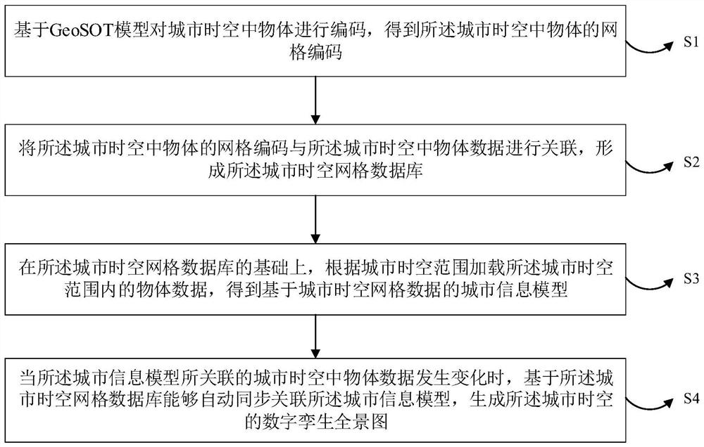
According to a city information model modeling method based on the space-time grid data, the method comprises the steps of coding city space-time space objects based on a GeoSOT model, and obtaining grid codes of the city space-time space objects; associating the grid codes of the urban space-time space objects with the urban space-time space object data to form an urban space-time grid database; on the basis of the city space-time grid database, loading object data in the city space-time range according to the city space-time range to obtain a city information model based on the city space-time grid data; when the city space-time space object data associated with the city information model changes, the city information model can be automatically and synchronously associated based on the city space-time grid database, and a city space-time digital twin panorama is generated. The method can solve the data fusion problem of combining GIS with BIM, converts object-oriented data organization into space-oriented data organization, and has the advantages of data service on-demand flexibility, city information model openness, data inheritance and the like.

Description

technical field [0001] The disclosure belongs to the field of information technology, and in particular relates to a modeling method of urban information model based on spatio-temporal grid data. Background technique [0002] There is an obvious limitation in the traditional GIS (Geographic Information System, Geographic Information System) combined with BIM (Building Information Modeling, Building Information Modeling) CIM (City Information Modeling, Urban Information Modeling) modeling method, that is, the data bearing based on the GIS layer The method fails to solve the data dynamic problem of the spatio-temporal model in essence, and the two-dimensional form of GIS layered data cannot meet the three-dimensional expression requirements, nor can it realize the expression of temporal changes. However, the singleness of BIM modeling is too strong, it is difficult to achieve integration between different BIM models, and it also cannot realize the expression of temporal change...

Claims


Application Information

Patent Timeline
Patent Type & Authority Applications(China)
IPC IPC(8): G06F16/29G06T17/00
CPCG06F16/29G06T17/00
Inventor 黄朔李林任伏虎刘彬彬王敏刘杰
Owner 北斗伏羲信息技术有限公司
Why Eureka
Try Eureka