Unmanned aerial vehicle path planning method with endpoint direction and time constraints

A time-constrained, track-planning technology, applied to navigation calculation tools and other directions, to achieve the effect of improving the problem of circumnavigation

Inactive Publication Date: 2020-04-17
SICHUAN UNIV
View PDF15 Cites 5 Cited by
  • Summary
  • Abstract
  • Description
  • Claims
  • Application Information

AI Technical Summary

Problems solved by technology

[0006] The purpose of the present invention is to solve the UAV track planning problem with endpoint direction and time constraints, so that the planned track is more in line with the actual situation and better

Method used


Image

  • Unmanned aerial vehicle path planning method with endpoint direction and time constraints
  • Unmanned aerial vehicle path planning method with endpoint direction and time constraints
  • Unmanned aerial vehicle path planning method with endpoint direction and time constraints

Examples


Embodiment Construction

[0033] In order to make the objectives, technical solutions, and advantages of the embodiments of the present invention clearer and more specific, the present invention will be further described in detail below in conjunction with the accompanying drawings and examples of implementation.

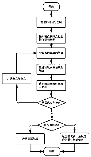
[0034] The present invention proposes a UAV track planning method with endpoint direction and time constraints, the flow chart of which is as follows figure 1 As shown, the specific steps are as follows:

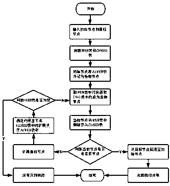
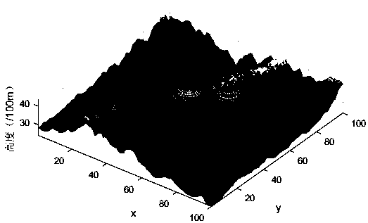
[0035] (1) Build the environment and divide the space: load the .mat terrain file, which stores the three-dimensional coordinate points of the terrain, and the maximum coordinate values ​​in the directions of X, Y, and Z axes , , , and the number, coordinates, and minimum radius of the radar and the maximum radius , and generate the required terrain surface map, and then divide the space into regular grid units according to the minimum step size of the UAV flight, each vertex of t...


PUM


Abstract

The invention provides an unmanned aerial vehicle path planning method with endpoint direction and time constraints. The method comprises the following steps: constructing an environment and dividinga space; inputting coordinate positions and corresponding orientation angles of a starting point and a terminal point, and calculating a new starting point and a new terminal point; improving a sparseA * algorithm, increasing acceleration cost in a cost function, adjusting node acceleration cost values with the goal of reaching the end point in the specified time as the criterion, and using the algorithm for path planning; adding the original starting point and terminal point into a path; and carrying out bidirectional search, and selecting an optimal flight path to output for finishing flight path planning. The method is based on the improved sparse A * algorithm, the problem of flight path planning of an unmanned aerial vehicle under complex constraints can be solved, and complex constraints include endpoint direction constraints of departure and arrival at a preset angle, time constraints, unmanned aerial vehicle kinematics constraints and obstacle threat avoidance constraints.

Description

technical field [0001] The invention relates to a UAV trajectory planning method with endpoint direction and time constraints, belonging to the field of trajectory planning. Background technique [0002] UAV trajectory planning refers to the UAV finding a feasible trajectory from the starting point to the target point under the conditions of performance, terrain environment and mission constraints. Due to the complexity of the hostile environment on the battlefield and the constraints on the performance of the drone itself, planning the trajectory for the drone can better adapt to the environment, avoid threats, improve the safety of the drone, reduce the range, reduce fuel consumption, and reduce maneuvering Operations to ensure the completion of scheduled tasks. [0003] The current heuristic algorithms used in path planning include A* algorithm, genetic algorithm, particle swarm algorithm, ant colony algorithm, etc., among which A* algorithm is simpler and more efficient...

Claims


Application Information

Patent Timeline
Patent Type & Authority Applications(China)
IPC IPC(8): G01C21/20
CPCG01C21/20
Inventor 李辉俞瑞黄操陈希亮王壮
Owner SICHUAN UNIV
Why Eureka
Try Eureka