Method and device for correcting cloud scattering error of laser altimeter

An error correction and laser technology, which is applied in the field of satellite laser altimetry, can solve problems such as the inability to correct the altimetry results, and achieve the effect of accurate altimetry deviation correction value and simple calculation process

Active Publication Date: 2022-03-18
自然资源部国土卫星遥感应用中心
View PDF10 Cites 0 Cited by
  • Summary
  • Abstract
  • Description
  • Claims
  • Application Information

AI Technical Summary

Problems solved by technology

[0003] Therefore, the technical problem to be solved by the present invention is to overcome the defect in the prior art that the correction of the altimetry result cannot be completed quickly, thereby providing a method and device for correcting the cloud scattering error of the laser altimeter

Method used


Image

  • Method and device for correcting cloud scattering error of laser altimeter
  • Method and device for correcting cloud scattering error of laser altimeter
  • Method and device for correcting cloud scattering error of laser altimeter

Examples


Embodiment 1

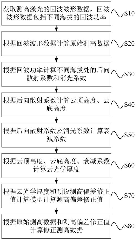
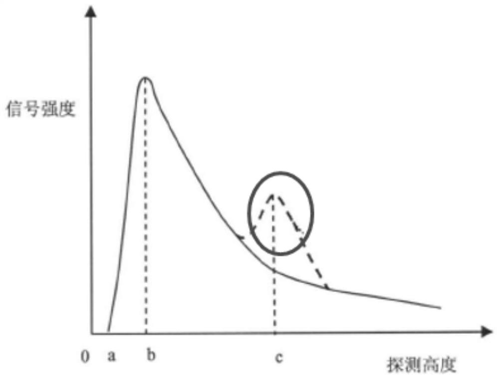
[0030] Satellite laser altimetry is a technology that can obtain sub-meter or even centimeter-level elevation information at high frequency and in a wide range, and has become one of the important means of earth observation. When using satellite laser altimetry, in order to ensure the elevation accuracy of the acquired data, cloud is a factor that cannot be ignored. And the researchers found that the influence of clouds on satellite laser altimetry mainly comes from the multiple scattering effect. Based on this finding, the researchers simulated the impact of cloud multiple scattering on the accuracy of laser altimetry data under specific conditions based on the semi-analytic Monte Carlo method. The results show that the altimetry deviation is related to various factors such as cloud layer height, cloud effective particle radius, cloud optical thickness, concentration, etc. Therefore, the altimetry deviation must be corrected based on real-time atmospheric observation parameter...

Embodiment 2

[0093] The embodiment of this case provides a kind of laser altimeter cloud scattering error correction device, such as Figure 5 shown, including:

[0094] The echo waveform data acquisition module 10 is used to acquire the echo waveform data of the altimetry laser, and the echo waveform data includes echo power at different altitudes. For a detailed description, see the description of step S10 in the above-mentioned embodiment 1.

[0095] The original altimetry data calculation module 20 is used to calculate the original altimetry data according to the echo waveform data. For a detailed description, refer to the description of step S20 in the first embodiment above.

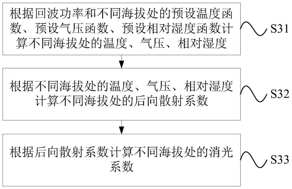
[0096] The backscatter coefficient calculation module 30 is configured to calculate the backscatter coefficient and extinction coefficient at different altitudes according to the echo power. For detailed description, refer to the description of step S30 in the above-mentioned embodiment 1.

[0097] The cloud d...

Embodiment 3

[0104] The present invention also provides a computer device, such as Figure 6 As shown, the computer device mainly includes one or more processors 91 and memory 92, Figure 6 A processor 91 is taken as an example.

[0105] The computer device may also include: an input device 99 and an output device 94 .

[0106] Processor 91, memory 92, input device 99 and output device 94 can be connected by bus or other ways, Figure 6 Take connection via bus as an example.

[0107] The processor 91 may be a central processing unit (Central Processing Unit, CPU). Processor 91 can also be other general processors, digital signal processor (Digital Signal Processor, DSP), application specific integrated circuit (Application Specific Integrated Circuit, ASIC), field programmable gate array (Field-Programmable Gate Array, FPGA) or Other chips such as programmable logic devices, discrete gate or transistor logic devices, discrete hardware components, or combinations of the above-mentioned ty...


PUM


Abstract

The present invention provides a cloud scattering error correction method and device for a laser altimeter, wherein the method includes: acquiring echo waveform data of the altimetry laser, the echo waveform data including echo power at different altitudes; calculating Raw altimetry data; calculate backscatter coefficient and extinction coefficient at different altitudes according to echo power; calculate cloud top height and cloud base height according to backscatter coefficient; calculate attenuation coefficient according to backscatter coefficient and extinction coefficient; calculate cloud top height according to cloud top height , cloud base height, and attenuation coefficient to calculate the cloud optical thickness; calculate the altimetry deviation correction value based on the cloud optical thickness and the altimetry deviation model caused by atmospheric scattering; calculate the corrected altimetry data based on the original altimetry data and the altimetry deviation correction value. This method not only can quickly calculate the height measurement deviation correction value, but also the calculated height measurement deviation correction value is relatively accurate.

Description

technical field [0001] The invention relates to the technical field of satellite laser altimetry, in particular to a method and device for correcting cloud scattering errors of a laser altimeter. Background technique [0002] Satellite laser altimetry is a technology that can obtain sub-meter or even centimeter-level elevation information at high frequency and in a wide range, and has become one of the important means of earth observation. However, when there are clouds in the atmosphere, the laser pulse is stretched due to the influence of multiple scattering and absorption by the cloud, which will cause deviation measurement and delay in the receiving time of the pulse center of mass when it is received. To obtain the elevation accuracy of the data, the cloud is a factor that cannot be ignored. And the researchers found that the influence of clouds on satellite laser altimetry mainly comes from the multiple scattering effect. Based on this finding, the researchers simulat...

Claims


Application Information

Patent Timeline
Patent Type & Authority Patents(China)
IPC IPC(8): G01S7/487G01S7/497G01S17/10
CPCG01S17/10G01S7/4873G01S7/497
Inventor 唐新明李国元幺嘉棋高小明陈继溢窦显辉李鸿洲金建文胡柳茹
Owner 自然资源部国土卫星遥感应用中心
Why Eureka
Try Eureka